GIS manager Courtney Granite seeks to instill a collaborative approach to data management and sharing at the City of Las Cruces, New Mexico. The city is the state’s second-largest city and home to New Mexico State University. Partnering with Esri to deploy an adoption strategy helped her build consensus for change and a growing enterprise mindset across the city.
A self-described “data person,” Granite is passionate about using location intelligence to inform decision-making. Las Cruces has a decentralized GIS model that is coordinated through Granite’s team and housed in the Community Development department.
Her team supports GIS staff and users in other departments, including utilities, economic development, public works, quality of life, public safety, parks and recreation, and the city manager’s office. The GIS team also provides reporting that supports departmental metrics and performance management initiatives and helps leaders measure progress on the city’s strategic comprehensive plan, Elevate Las Cruces.
Granite stepped into her current role in October 2019. From the beginning, she wanted to encourage an enterprise approach to information and GIS.
“I came from IT and very much a data-focused background,” said Granite. “I wanted to grow [the GIS program] with an emphasis on data governance rather than the old-school way of doing things.”
The “old-school way” included fielding myriad requests for GIS maps and data. Each department worked with its data in a silo, which made it a challenge to access and report all relevant data to support decision-making.
In conversation with Esri senior training consultant Tosca Hoffmann, Granite described her vision for broader use of GIS and collaboration across teams and city programs. Hoffmann told Granite that other GIS managers she worked with had similar goals. GIS awareness and data silos are common challenges, and Esri has created an adoption strategy practice to help organizations overcome these barriers.
Building a Playbook to Grow GIS Adoption
With her interest piqued, Granite met with Esri consultant Lyndal Brookhart. The two agreed that an adoption management playbook engagement would help advance Granite’s vision for Las Cruces.
Granite approached the city’s GIS steering committee. After explaining the current state of GIS practice and the need for change, she asked the committee to assign staff to participate in playbook meetings. The committee could see the value of making changes that would help report on data in a way that made sense, increased standardization, and built trust in enterprise information.
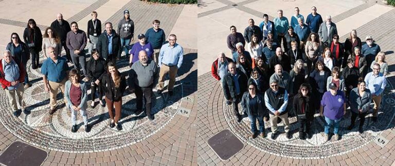
With the steering committee’s approval, the adoption management playbook moved forward. Granite felt it was important to bring as many departments into it as possible. Representatives from 10 city departments participated in seven working sessions facilitated by Brookhart. After talking through what they were trying to achieve and why it was critical to the city’s future, they brainstormed specific approaches and the steps that would be needed to accomplish their goals.
“We had close to 20 people involved from across all the key functional areas of the city—and they showed up and were present and contributed. This initiative was owned by everybody,” said Granite.
To reinforce the importance of the effort and its collaborative spirit, the group named their initiative Connect Las Cruces: Empowering GIS Modernization Across the Enterprise. They also crafted a big opportunity statement in the Las Cruces adoption management playbook that encapsulates the initiative’s benefits: “We can positively support our livability, prosperity, and environment by leveraging location intelligence technology that supports critical decisions. By increased cross-functional department and community data-sharing practices, we can better understand where we are, who we are, and how we grow together.”
The group tasked a smaller adoption management team to implement the playbook. Five participants, including Granite, were assigned to this team. Brookhart facilitated discussions that resulted in the development of a solid plan. “We agreed the action items were very doable,” said Granite.
Communicating the Vision
When the playbook engagement began in spring 2022, Las Cruces had 230 active ArcGIS users, which included GIS professionals, light users, and staff who viewed web maps and apps. By the end of 2022, there were 380 active users—an impressive growth of 39 percent.
To achieve that growth, Granite deployed the playbook’s communications strategy and set out to convince department leaders—key influencers for change—that location intelligence could improve decision-making and enhance their operations. Department by department, she met with managers and program staff to gain their interest and build a desire to do more with GIS.
She framed her presentation every time using a key theme: “the power of visualizing your data.” Every time, she explained how GIS could improve the workflows and programs supported by the department and each user role within the department. Her goal was to inspire everyone with a clear picture of what could be—a future in which location intelligence infused decision-making would drive efficiencies and smart resource allocation. This would help make Las Cruces an even better place to live, work, and do business.
“I wanted the change network to understand the importance and outcome of making a commitment to the plan—how it would take us to the next level and the benefits we would gain,” stated Granite.
Engaging End Users
Because Las Cruces has an Esri Small Government Enterprise Agreement, many city employees have access to ArcGIS software. Encouraging a self-service model for GIS is a key goal of Connect Las Cruces.
During the playbook sessions, the team identified workforce development as an important strategy to grow GIS skills and build excitement among the staff to use GIS. To execute this strategy, the team deployed an in-house training initiative named Connect Onsite, which authorized city staff to attend GIS-related training courses four hours a month over a period of four months.
Connect Onsite launched in October 2022 with four one-hour, hands-on workshops designed to grow foundational skills in GIS-based enterprise best practices that aligned with departmental workflows. GIS technician Alejandro Samaniego helped create and deliver the workshops.
“My personal goal was to inspire more interest in GIS,” said Samaniego. “I felt like if it was your coworker showing you what they do with this program, how they use it, and giving examples of how useful it could be, it would inspire participants to apply GIS to what they do.”
Introducing a fun activity helped set Connect Onsite up for success. The adoption management team decided a virtual, story-based scavenger hunt would attract interest and increase workshop participation. The team devised a series of questions for scavenger hunt participants to answer using a web map. The activity introduced GIS terms and taught participants how to identify features, add points, create simple data, and follow routes and lines. Those who accurately completed the monthly scavenger hunts were entered into a drawing for a prize.
“It’s all about training and getting them inspired to use GIS,” said Samaniego.
Connect Onsite Delivers Success
Workshop participants were asked to bring project data so they could immediately apply the training to their own work.
“What we saw was pretty remarkable,” said Granite. “The people who really put the time in to be engaged got a lot out of it.”
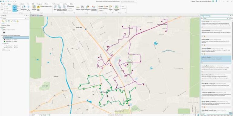
One participant from the Quality of Life Department brought data for the meal delivery program she supported. Her goal was to reduce food waste resulting from delays in delivering the meals. In the workshop, she learned how to create a map of city streets and overlay the meal delivery locations. Then she worked with a GIS staff member to optimize delivery routes. Delivery drivers with deep knowledge of city streets and traffic patterns helped further optimize the routes. By including the drivers, everyone involved with the program was empowered to improve it—a tangible example of the benefits of GIS, collaboration, and “the power of visualizing your data.”
“The meal delivery program was able to transition from using a third-party solution to an internally supported tool,” said Granite. That success sparked interest from another department.
“Risk Management staff noticed [the Quality of Life employee] working on her map and her enthusiasm for the data,” Granite said. “Now they’re interested in attending a future session because they can see how it would be applied to some of their scenarios and the data they’re utilizing.”
Another success occurred after three police department employees attended a workshop. They brought data for projects they needed to complete and a week later, Granite received a phone call from a deputy chief requesting a customized training session.
“Maybe they used GIS in the past, but they weren’t using it to its full potential,” she said. The deputy chief now mandates that his team use GIS to help solve crime in specific areas of the city.
After completing the in-house training, some participants wanted to continue growing their GIS skills. Hoffmann works with Granite to provide Esri course recommendations for those employees. Overall, Granite and Samaniego are very pleased with the impact of the training.
Painting Their Own Canvas
Building on the Connect Onsite success, Granite and Samaniego are on a mission to enable more employees to confidently apply GIS tools themselves.
“I want GIS to be a change agent for the city, a catalyst for creative thinking and innovative workflows that utilize GIS to report on and share data and information,” said Granite. “Historically, people came to the GIS department and asked, ‘Hey, GIS, can you do [this task] for us?’ Of course, we can, but we want subject matter experts to be empowered through training and access to software tools to paint their own canvas and make informed decisions using the data that matters to them.”
Samaniego concurred. “When someone requests a task, for me it’s just a task,” he said. “But if they know how to use the program and it’s their own work, they’re going to have a higher investment in the outcome and be more creative. By giving everyone the tools, the products we put out as a city will improve because we’re all working on what we care about rather than simply completing tasks.”
Building Communities of Practice
While the number of GIS users has grown significantly since Connect Las Cruces started, Granite hasn’t set a target.
“I’m a data person so I like numbers, but this is about providing a service to others and helping them see the value of using the technology.”
Asked about her next step, Granite answered, “I think what I’m really looking for is to continue making connections. This year, we plan to offer a communities-of-practice program. One will focus on GIS, and another will be around data science. If we can develop these internally and in the community, then I will have met what I think is a good goal.”
She is well on the way to achieving her goal. Her team is helping forge a regional GIS community of practice. Several agencies, including Doña Ana County, Mesilla Valley Metropolitan Planning Organization, New Mexico Land Conservancy, and the Mesilla Valley Regional Dispatch Authority, have expressed interest. She wants to see how they can better share and make use of data. “Connecting with GIS and data professionals from different agencies is going to really help us,” said Granite.
For more information on Connect Las Cruces, contact cgranite@lascruces.gov.