In recent years, the State of Oregon has faced a significant increase in the frequency and intensity of wildfires, making efficient and timely disaster management a top priority. The Oregon Department of Emergency Management (OEM) coordinates and maintains a statewide system for emergency and disaster communications.
Maintaining an accurate and accessible system of maps is a necessary part of responding to emergency situations across the state. However, according to Curtis Peetz, a response planner at OEM, the agency has faced multiple challenges in maintaining and updating its maps. These maps are crucial for providing clear and effective situational awareness about the status of various incidents and state agencies’ responses to them.
The department needed to find a way to improve information-sharing and
decision-making processes, particularly during emergency events. By leveraging ArcGIS Instant Apps, OEM has not only improved its partners’ access to critical information but also enhanced the reliability of the data being reported.
Information Delay
In the past, OEM staff built a common operating picture by manually compiling information from various sources to create situation reports. These reports included photographs of maps, which were then inserted into a Microsoft Word document and published in the afternoon, showing data that was 8–12 hours old. The delay meant emergency response teams did not have the up-to-date information they needed.
The OEM information and planning team used an app template designed for presenting a related set of maps to show incident areas such as wildfire locations. With this system, any data required for daily situation reports had to be manually collected, a task that included processing requests for assistance and compiling statistics. This had to be repeated every 12 hours. Despite the maintenance and update challenges, maps served as a foundational element in OEM operations.
“It was extremely . . . time-consuming, and not always very accurate,” explains Kelly Jo Craigmiles, OEM operations and emergency program coordinator.
When specific information was required, the team would put in a request for the GIS specialist to gather data. However, the team frequently found that the requested data wasn’t what was needed, leading to additional requests for different information.
An Instant Solution
To address these challenges, OEM turned to ArcGIS Instant Apps. The small team had limited time to develop custom solutions, so the ArcGIS Instant Apps gallery—including preconfigured app templates as well as an express mode, which allows users to quickly configure and create an app—proved incredibly useful.
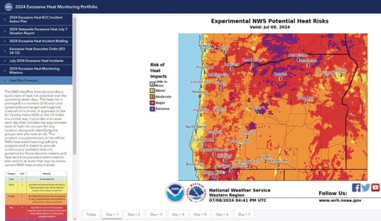
Daniel Stoelb, GIS program coordinator for OEM, used the Instant Apps Portfolio template, which is designed to present a series of maps, scenes, and apps as well as other content such as images, PDF files, and embedded web pages. This template allows maps and apps to be assembled in one place. The maps can also be shared on a new, publicly available website, giving the community better situational awareness after natural disasters.
According to Peetz, the flexibility and user-friendly nature of the apps has allowed nontechnical team members to contribute and update information, and enabled Stoelb to set up a replicable template for future events. In fact, OEM’s entire setup and training on the solution took only 30 minutes, during a meeting of the Emergency Support Function Information and Planning (ESF 5) workgroup. ESF 5 aims to coordinate and support emergency management activities.
“It’s about getting a baseline template set up and writing procedures. The steps to success were very easy because it’s a repeatable process and people are familiar enough with the product,” Stoelb said.
Everyone in the ESF 5 workgroup can help maintain the portfolio template. They are trained to create new sections in the template, attach and save PDF files, and share updates with the group and response partners, and all have ArcGIS Online accounts.
The training is straightforward and supported by visual aids like screenshots to simplify navigation and make it easy for team members to upload and update information as needed. The flexibility of the system allows them to adjust what can be displayed and provide a situation report. When the National Weather Service or other partners send updates in the form of PDFs, these updates are easy to incorporate into the Portfolio template as new tabs within the incident portfolio.
The new site delivers a comprehensive report on any given emergency by providing links to real-time data on weather conditions, air quality, heat risks, and potential hazards. “The goal of our portfolio really is to be that comprehensive, common operating picture to point people to and say, ‘Go here, and here’s where you get the information about what’s happening in this incident,’” said Peetz.
A Framework in Place
OEM’s integration of ArcGIS Instant Apps has enhanced the department’s situational awareness and information-sharing capabilities. The app compiled all relevant information in one place and improved situational awareness about potential and ongoing hazards. This helps partners like the Oregon State Fire Marshal and the Oregon Department of Forestry make informed decisions, fostering a more informed response community. The app also facilitates real-time updates and comprehensive documentation during an incident.
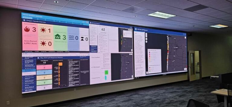
“It’s a lot easier to initiate our response at the beginning of an incident when we already have expectations set,” explains Stoelb. “Using templates, we prearrange all necessary tabs, streamlining the transfer of information to the Planning section with data from other authoritative sources.”
According to Stoelb, setting up a portfolio based on a preexisting template took around 15 minutes, while creating a new application from scratch could take multiple hours. The template allowed the team to shift focus from the standard data they typically provided so that they could research what they were missing instead.
Stoelb keeps existing hazard templates in a folder in ArcGIS Online, which makes them easier to replicate for new events and allows for the preservation of standard formats like icons and color codes. This ensures consistency of information and saves OEM time when setting up a new app for emergency events.
“We all know what we’re going to get. There are no surprises. It’s wonderful. It saves so much time and it’s a known quantity, something we can expect every single time,” Craigmiles said.
Dynamic Results
ArcGIS Instant Apps facilitates information sharing through links, ensures that the information OEM provides is current with source updates, and enables access to real-time information from partners. Now, OEM staff can guide individuals directly to primary sources, which are also documented on each tab of the incident portfolio.
The app also allows users to clearly see areas where a wildfire may be encroaching on a population, as well as shelter locations. This offers a much clearer method of viewing information compared to traditional static paper documents.
Information is now accessible to local counties, tribal jurisdictions, and response partners, which often operate with minimal staff and resources. Providing these groups with the same information in near real time allows data to guide their decision-making.
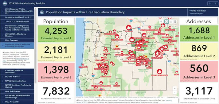
“[Elements] can change so very quickly during wildfires that we’re giving them that real-time data so that their elected officials can make determinations and decisions on what [they] need to do…to help protect [their] populace the best by being able to visualize that,” said Stoelb.
Combining static and dynamic information offers a clear and impactful visual representation of situations. The Federal Emergency Management Agency (FEMA) Regional Response Coordination Center (RRCC), which collaborates with OEM, has frequently said the app’s near real-time information and visuals are helpful for disaster declaration requests. This visual approach significantly enhances the agency’s understanding of an incident’s severity. FEMA now has data in one place, which streamlines the approval process and gets Oregon the funding needed to help residents recover.
With this app, “folks have consistent and timely information provided at the local level as well as up to our executive leadership to help us save lives,” said Peetz.

