To support a booming population that is growing at a rate of 2.32 percent annually, the City of Grimes, Iowa, is broadening its essential services such as utilities, law enforcement, and building infrastructure. To keep up with its residents’ needs, Grimes realized it was necessary to expand the city’s enterprise system and ensure dependable IT infrastructure that would enhance operations and boost productivity.

The city, which deployed ArcGIS Enterprise in 2022, has a robust multimachine GIS implementation. Greg Jameson, GIS technician for the City of Grimes, is responsible for managing the city’s enterprise GIS, including deploying servers, managing licenses, and gathering metrics. He wanted more data and details than were available from the previous monitoring solution to ensure the system was running optimally.
More Performance Information Needed
The self-hosted monitoring tool the city used previously delivered limited information on system health. Although it was helpful in validating that GIS server administration web pages were up and had responded within the last 20 minutes to a web service, it didn’t provide details on how the enterprise
portal was working. Essentially, it just showed whether a service could receive web traffic. Jameson wanted more insight and capabilities.
“At the end of the day, our city council wants to make sure we’re being the best fiscal stewards that we can. And so [it’s helpful] having some metrics to highlight what is our uptime, how much is being used, how is it cutting down on staff time to find data to do things. And [our previous tool] just doesn’t give us any of that,” said Jameson.
The additional insight would also help Jameson know if he was properly publishing services. As the ArcGIS Enterprise deployment was new to the city, he wanted to get data on specific items such as the accuracy of load balancing numbers, maximum instances being used, performance of services, or identification of the core services that might have more end-user demand. With limited time, Jameson wanted more informed metrics delivered to him.
“Because I’m new to ArcGIS Enterprise, I want to [see] if I should select a shared or a dedicated instance? That is so specific, and I don’t have that time to go and hunt that [data] down,” he explained. “I only have so much time in the day to validate services or things that are up. So, it was more of a reactive situation for me.”
The City of Grimes has evolving needs, and its fast-growing multimachine GIS deployment must be flexible. The current system includes an enterprise portal, a web server, a GIS server, ArcGIS Data Store, an image server, a single machine test/development ArcGIS Enterprise deployment, a shared Microsoft SQL Server instance, and an ArcGIS Monitor server.
One-third of the city staff—some 20 to 25 people—use internal services daily. Jameson noted that since it’s impossible to know what city staff use cases may be in the future, he wanted a tool that would grow with the city’s needs.
“Initially monitoring and making sure that things were OK, I was trying to check at least once a week to make sure all the services were there. Well, each week I’m adding another service or two,” said Jameson. “So, each week it only extends more and more.”
Affordable and Seamless Integration
Through the city’s enterprise agreement with Esri, Jameson had access to the entire ArcGIS technology stack. He was looking for an Esri tool that would provide seamless integration and be affordable. Jameson connected with Esri staff and learned about ArcGIS Monitor, a solution designed to help analyze and optimize the health of an ArcGIS implementation throughout the life cycle of an enterprise GIS.
He chose ArcGIS Monitor, an enterprise-grade monitoring solution, to provide the information about the health and performance of the GIS he required. Jameson liked that ArcGIS Monitor provided a user experience similar to that of the enterprise portal and could provide more meaningful insight into the GIS. During deployment, he found Monitor documentation was very helpful. Jameson worked with a colleague who was also testing and setting up Monitor in his organization. Jameson says they frequently talked to exchange ideas and tips.
Jameson began setting up Monitor by asking the IT department to provide a server for Monitor with Esri’s recommended specifications. He installed the software, built the PostgreSQL database, and began registering components with Monitor. He began receiving data metrics about the GIS system within minutes.
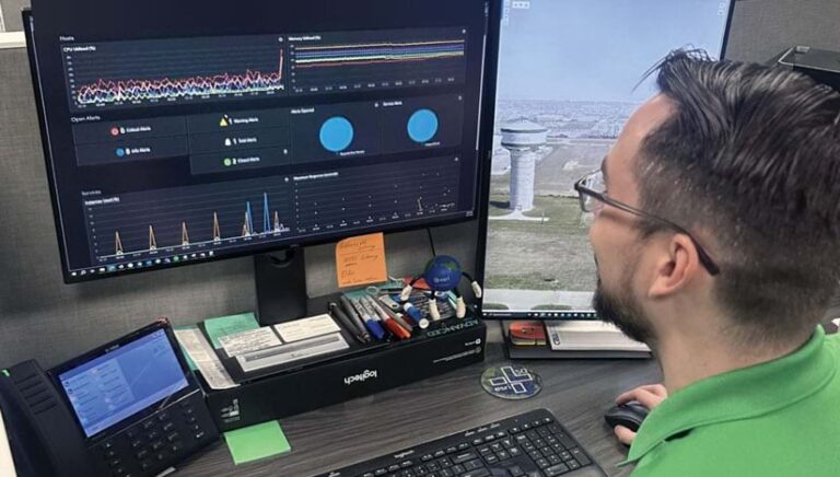
Now, Jameson checks Monitor every morning to see if any errors occurred overnight that need his attention. These alerts are also sent directly to his email inbox via notifications. The IT department has login information as well to view and help address potential system issues.
Ensuring Enterprise Reliability
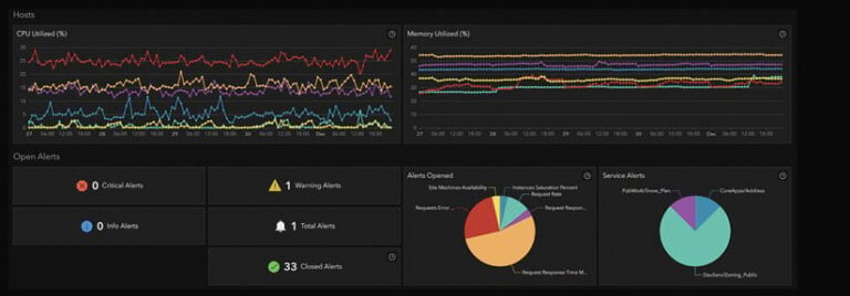
Since its deployment in February 2023, Monitor has helped deliver reliability to the City of Grimes staff. It gives Jameson a snapshot of the entire GIS system and its performance. He primarily looks at CPU, memory allocations, alerts, and status changes for the enterprise GIS and he can easily see how all the components are working together.
“Because it is just me as a staff member between managing the training of the staff and launching Esri solutions, Monitor has helped me to free up that time to focus on other things. Monitor is my go-to thing to put up, to engage [with]…because it tells me if there’s an issue or a latency,” said Jameson.
Jameson ensures that the organization’s 90-plus services are properly running and response times for users are adequate. Monitor has given Jameson deeper insight into the system, which has helped him be more proactive when addressing GIS issues.
Jameson can also determine the layers that staff use most often, which helps confirm proper delivery. For example, Jameson’s golden rule for delivering aerial image cache is under one second. He can better monitor this internal benchmark and current system demand. When new services are published, they are immediately available to view in Monitor. This has been especially helpful for Jameson since he adds new services weekly, and metrics are gathered automatically. According to Jameson, the metrics give him the core information he needs to make a quick decision.
“That level of automation and connectivity within Monitor is fantastic. I don’t have to do any more maintenance [because] it takes care of itself for me. It’s one less thing for me to update when I build the next thing,” said Jameson.
The metrics also help Jameson understand the new ArcGIS Enterprise system and gain better insight into how the software functions. For example, he can better understand the demand on the system when there is an upgrade by checking the upgrade or patching loads.

The alert notifications sent by Monitor and the custom reports (e.g., Analysis views) that are producible have been a significant advantage for monitoring system health. For example, Jameson created a custom report to check ArcSOC usage. [When a client app makes a request to any service running on your ArcGIS Server site, such as to draw a map, geocode a dataset, or run a geoprocessing job, that request is passed to an ArcSOC process on one of the machines in the site.] The custom report provides details on the load when a new service is deployed. This helps Jameson know when the new services are being used without having to review them layer by layer within the database. ArcSOCs are the process on the server handling dedicated and hosted services. A serial chart produced by Monitor allows insight into the demands of service on the hardware itself.
Jameson finds the default alerts in Monitor very helpful, particularly those that check storage space. Monitor allows him to tailor the alerts, such as changing the data retention policy to keep at least six months of information so he can view growth trends in the long term. Leadership at the City of Grimes has been very supportive of Jameson’s work and sees the value of GIS.
ArcGIS Monitor has given Jameson the metrics he needs to get a complete view of the system and deliver reliable services to city staff. He looks forward to expanding the city’s GIS capabilities and continue monitoring system health so that he can deliver a better experience to staff. “ArcGIS Monitor has given me back [time every week for] monitoring our deployment as a whole, whether that’s log files or making sure services are up. It allows me to be proactive rather than reactive, and then allows our platform to continue to accelerate faster and faster,” Jameson said.
“What is our vision? We want to empower location-based data to anybody. We just want to have every employee have access to GIS at their fingertips as a tool to perform their job more efficiently,” said Jameson. “And additional efficiency will be gained over time as we continue to mature our GIS environment and our city.”


