Do you know what kind of future you are planning?
Is it a future that preserves the quality of air, water, and land systems for our descendants? Because a sustainable future does not happen by default or by accident, Esri launched the Green Infrastructure initiative to help you and decision-makers—both within and outside of government—plan a better future for the United States using GIS.
There is a pressing need to ensure that the nation’s valuable landscapes are not sacrificed as a result of development that is haphazard or poorly conceived. Unlike the gray infrastructure of bridges, roads, dams, and other structures, this green infrastructure is precious and cannot be rebuilt once it is lost.
Green infrastructure is actually an old idea that has new vitality, thanks to GIS technology. Frederick Law Olmsted, the acknowledged founder of American landscape architecture, recognized the value of setting aside tracts of land and preserving natural scenery for the enjoyment of everyone, not just the wealthy. Olmsted was a board member of the commission appointed to oversee the first national park, Yosemite. In his 1865 report, Olmsted noted that the preservation of the area’s scenic beauty would generate not only economic returns from tourism but also tremendous benefit to the physical and spiritual well-being of the nation’s inhabitants.
The objective of the Green Infrastructure initiative is a systematic, information-based method for transforming communities in the United States into sustainable centers by identifying and preserving an interconnected system of landscapes at regional, local, and urban scales. This means addressing green infrastructure proactively at the beginning of the planning process, rather than reactively at the end.

A green infrastructure approach to development identifies critical landscapes of ecological, scenic, and cultural value and preserves them. Ecologically valuable landscapes contain features that benefit all living organisms in an area, not just people. Scenic and culturally valuable landscapes are characterized by recreational areas, viewsheds, and similar features that increase property values and promote tourism.
To be effectively safeguarded, these areas must be considered on multiple scales—regional, local, and urban. At each scale, maintaining the connectivity of open spaces, habitats, and parks is important because connectivity provides a resilience to the components of these landscapes that helps them survive challenges, such as climate change, better than isolated areas.
Previously, environmental concerns were set aside in favor of what was perceived as economic necessity based on the belief that these were competing rather than complementary aspects of a truly sustainable future. Green infrastructure makes solid economic contributions. Preserving watersheds protects the water supply and safeguards the health of human populations that use that water as well as the vegetation and wildlife that depend on it. Keeping coastal areas intact mitigates the effects of storm events and limits damage to buildings and other structures. Unmarred scenic views are valued and enhance property values.
Currently the majority of local government entities that regulate the use of the land base in the United States do so in isolation from each other and often without tools to effectively assess existing conditions or model the effects of proposed policy changes.
The time for implementing green infrastructure is now because GIS provides the tools needed to integrate, analyze, visualize, collaborate, and communicate this new vision for the nation.
GIS is essential to a green infrastructure approach to planning because it reverses the prevailing paradigm of developing first and relegating any leftover areas to green space afterward. Green infrastructure planning is fundamentally a spatial problem. With GIS, data about the natural world and built environment—from many sources, in a variety of formats and range of scales—can be combined and modeled to uncover patterns and perceive relationships.
Although GIS makes planning with accountability and metrics possible, a national dataset identifying intact, natural areas was needed. To enable a GIS-enabled approach to green infrastructure planning, Esri created a dataset using National Land Cover Database 2011 for the initiation definition of these “cores,” or intact areas. The result was the National Intact Habitat Cores Database.

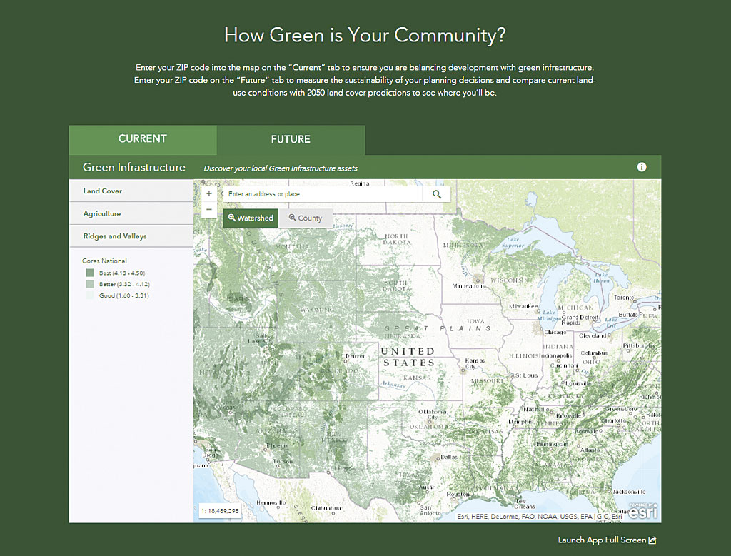
Using this dataset, Esri compiled the first national green infrastructure map depicting every intact natural area larger than 100 acres in the United States regardless of ownership or preservation status. This map shows areas of ecological, cultural, and scenic importance. Local and regional data can be combined with this national map to evaluate the current state and probable future of an area given planning policies. This lets decision makers determine what action will be required to preserve these valuable landscapes.
A suite of green infrastructure planning tools is available across the ArcGIS platform as online tools and desktop toolsets for use with the National Intact Habitat Cores Database. A simple online tool that lets anyone assess the current state of green infrastructure in their area is available at esri.com/greeninfrastructure on the Current tab. At the same site, on the Future tab, tools for modeling scenarios based on filtering and weighting the core data to reflect community values can be used to generate layers that can be viewed or used with GeoPlanner for ArcGIS.
GeoPlanner for ArcGIS is a web application for planning professionals that is integrated with ArcGIS Online and runs in desktop and tablet web browsers. A premium app offered in the ArcGIS Marketplace, it provides tools that support every step in an end-to-end, geoenabled planning and design workflow. Esri also provides toolsets for ArcGIS for Desktop and ArcGIS Pro that are available at no charge from ArcGIS Online.
Planners, elected officials, researchers, businesses, and the public can find out the status of the green infrastructure in a community now and extrapolate the effects of current planning on the landscape. Local and regional data can be combined with the national map to evaluate the current state and probable future given current planning to see what action is required to preserve these valuable landscapes.
Communities can preserve natural habitats, protect biodiversity, promote healthier lifestyles, and improve quality of life by supporting intelligent and balanced growth. This approach to planning evaluates likely results against values.
Applying a green infrastructure approach to a community encompasses these four steps:
- Critically evaluate the community’s land development policies.
- Compare benchmarks for the community to other communities.
- Include a green infrastructure element in the community’s comprehensive land-use plan.
- Use GIS analysis and tools to ensure that the community stays on track to preserve its green infrastructure.
You can take the first step toward a more sustainable future by finding out the green infrastructure score of your community and entering your location.

