As organizations evolve and embrace digital transformation, digital and data strategies have become indispensable components of their success. And in this strategic planning landscape, the integration of geospatial elements has become critical. The central advantage of folding GIS into your business strategy is its ability to provide spatial context. This adds a new dimension to strategic initiatives, enabling businesses to gain deeper insights, delve into advanced analytics, optimize resources, and unlock opportunities for growth.
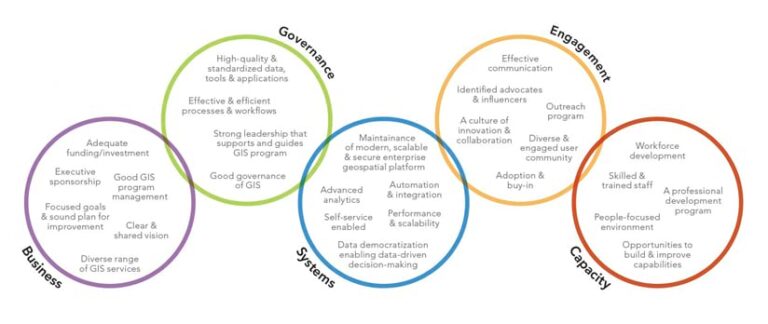
Building your organization’s GIS program on a strong foundation is essential to the success of your geospatial operations. Enter the Path to Geospatial Excellence web page, an online resource designed to help organizations implement and maintain a successful enterprise-class GIS environment. This programmatic approach involves five key components on which organizations can build their geospatial technology capabilities and leverage location intelligence to drive innovation and informed decision-making. These components are business, governance, systems, engagement, and capacity.
1. Business
Business is the first and most critical component to building a strong foundation for an organization’s GIS program. Aligning GIS with the organization’s mission, vision, and priorities is essential. The core of geospatial operations success involves thorough understanding of how location intelligence impacts business operations and outcomes. Organizations must align their GIS initiatives with their overarching business objectives, vision, and priorities while identifying specific use cases and applications where geospatial insights can deliver tangible value.
By integrating geospatial considerations into strategic planning and decision-making, businesses can harness the power of location intelligence to optimize processes, mitigate risks, and gain a competitive edge. A core element of this component is developing a geospatial strategy with executive backing and support. That means building a strong team with all the right people involved, who represent key aspects of the organization.

2. Governance
Effective governance is crucial for managing a geospatial operations program and ensuring alignment, impact, capacity, quality, and security. This component involves establishing clear policies, standards, and procedures that govern an organization’s geospatial operations program. This includes organization structure, GIS environment, data, applications, and tools. By implementing robust governance frameworks, organizations can maintain a comprehensive system, preserve data integrity, enforce compliance, and facilitate transparency and collaboration among stakeholders. Governance provides a decision-making structure, clear ownership, and organizational accountability needed to manage and allocate limited geospatial resources such as people, processes, and technology.
Organizations can struggle with various challenges when it comes to governing a geospatial operations program. Many of these problems stem from not having a clear understanding of policies and procedures or the capacity to address governance challenges. Knowing what challenges are most critical to your organization helps you optimize your resources and
organizational structure.
The national Geospatial Data Act (GDA) of 2018 and the FAIR Principles, introduced in 2016, spurred many organizations to begin their governance journey of geospatial data and technology. Several federal, state, and local government agencies established effective geospatial governance frameworks, policies, procedures, standards, best practices, and tools to ensure that their geospatial systems and data adhered to their strategic plans. This allowed the organizations to:
- Lead the development and management of geospatial data infrastructure with executive committees that oversaw geospatial assets.
- Establish and maintain best practices and standards for their critical organization geospatial assets and data.
- Establish and operate their geospatial platform in accordance with best practices and guidelines.
- Foster communication and collaboration with their key stakeholders.
- Identify and meet the needs of the users of geospatial data assets.
3. Systems
The systems component focuses on the infrastructure, data, innovation, and analytics that are needed to underpin geospatial operations. This includes identifying and implementing appropriate GIS software, databases, and hardware systems to effectively capture, manage, analyze, and visualize geospatial data. By investing in scalable and interoperable systems, organizations can enhance their analytical capabilities, streamline workflows, and facilitate seamless integration with other enterprise systems. At the core of this approach lies the recognition that ArcGIS serves as a system of systems, composed of a robust framework that encompasses systems of record, engagement, and insight. Additionally, a well-architected framework forms the bedrock for fostering innovation and ensuring the sustainability of long-term enterprise geospatial operations.
4. Engagement
The engagement component is critical to the success of geospatial operations program for several reasons. For one thing, it ensures consistent communication and collaboration with stakeholders, which is essential for gaining buy-in for the successful adoption of a geographic approach and actively engaging end users, decision-makers, and external partners throughout the geospatial operations program. This kind of active communication is also necessary when soliciting feedback and providing support to ensure user proficiency and ownership among stakeholders. By fostering a culture of engagement, organizations can maximize the value derived from geospatial technology investments, prepare the workforce for change, and drive broader organizational transformation.
One organization took a customer-centric approach by designating its customer success managers to serve as geospatial technology ambassadors. These ambassadors proactively engaged users across the organization to make sure that user needs were met, and provided active continued support. The customer success managers were responsible for:
- Managing a portfolio of geospatial technology stakeholders.
- Understanding the business and technical requisites for bringing added value.
- Managing geospatial project/product enhancements, delivery, and operations.
- Engaging a community of practice with staff enablement workshops.
- Providing skills development and capabilities enhancement plans for teams.
In essence, these ambassadors were pivotal in bridging the gap between technological capabilities and user needs, ensuring that the organization was successful in achieving its desired outcomes. By fostering a culture of engagement in this way, organizations can create sustainable and long-term success of geospatial technology adoption and operations.
5. Capacity
The capacity component focuses on building and nurturing the skills, new capabilities, and expertise necessary to leverage geospatial technologies effectively. This includes providing training, professional development, and career advancement opportunities for GIS professionals, analysts, and end users. By investing in capacity building, organizations can be certain that their workforce possesses the requisite knowledge and competencies to drive innovation and harness the full potential of geospatial tools. Capacity building also gives individuals capabilities that can impact the entire organization and deliver a geographic advantage that will support the organization’s mission. The continuous building of new capabilities and efficiencies throughout an organization is crucial to expanding capacity.
One success story involves an architecture, engineering, and construction (AEC) company that started with limited GIS capability. Staff built a workforce development plan that defined training for specific roles, then followed it up with certification attainment. This initiative generated new revenue for the AEC firm and got the attention of the CEO. Recognizing the value of new location capabilities, the CEO recommended that everyone attain Esri technical certification. Staff accomplished this within a year and saw their business grow. The company achieved that growth through persona-based training plans; validated knowledge via certification; and applied these concepts to employees’ work, thereby building robust capacity for additional business.

Characteristics of Success
Together, the five components provide a core framework and foundation to build a successful GIS program. When it embraces and aligns with these components, the benefits can be transformative.
Success in geospatial operations hinges on a comprehensive approach that addresses each of these key components. Success also requires thinking holistically about your GIS investment, not as a point solution technology but as an organizational enterprise capability. By prioritizing and reinforcing the interplay between business alignment, governance, systems integration, stakeholder engagement, and capacity building, organizations can unlock the transformative power of geospatial technology and drive sustainable growth and innovation. The Path to Geospatial Excellence web page is geared toward developing a mindset shift that can produce actionable strategies and build resilience.
The path to geospatial excellence is a continuous journey. Much like embracing a healthy lifestyle, building a successful geospatial operations program is a lifelong journey that provides numerous benefits along the way. Although there is no ultimate destination, you can continuously improve and strive to reach greater heights. As you and your organization navigate your own unique GIS journey, you can apply the path to geospatial excellence as a road map to assist you along the way.


