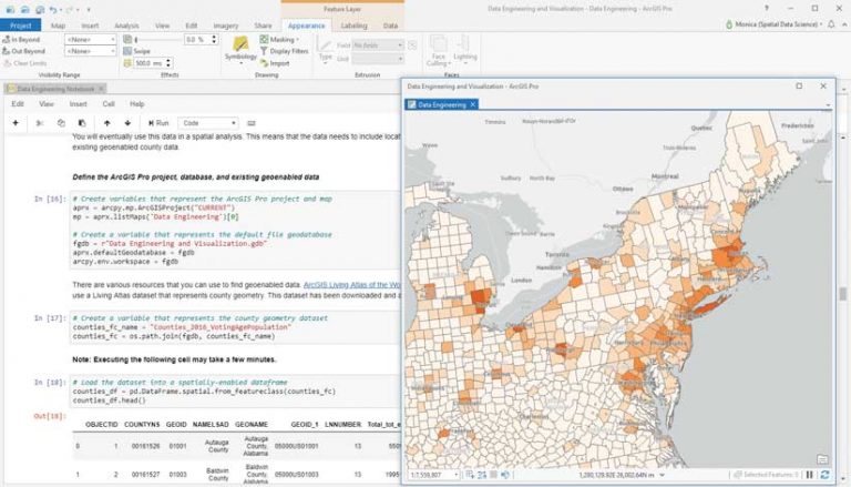
ArcGIS Notebooks lets you easily switch between the intuitive GUI of ArcGIS Pro and the scripting and annotated interface of Jupyter Notebook, providing a complete data science workstation.
In ArcGIS Pro 2.5, you can create, edit, and save a Jupyter Notebook as part of your ArcGIS Pro project with ArcGIS Notebooks, Esri’s Jupyter Notebook environment. You can create a notebook as part of an ArcGIS Pro project and edit the notebook using the Jupyter interface that now comes included in all editions of ArcGIS Pro 2.5. Access ArcGIS Notebooks in ArcGIS Pro simply by installing or upgrading to ArcGIS Pro 2.5 (Basic, Standard or Advanced license levels). No additional cost, installer, license, or app is required.
The notebooks you create in ArcGIS Pro will leverage the ArcGIS Pro Python environment, which can be customized through the Python Package Manager, the Python Command Prompt, or through Anaconda.

Why Use ArcGIS Notebooks?
ArcGIS Notebooks provides many benefits. It streamlines processes; makes collaboration easier; give you more convenient access to open-source Python; and lets you work seamlessly between ArcGIS Notebooks and the ArcGIS Pro UI, automate work; and build reproducible research.
Rather than having part of your analysis in ArcGIS Pro and another part in a separate Jupyter environment, ArcGIS Notebooks keeps a connection between ArcGIS Pro and Jupyter Notebook. Because you can store related notebooks within ArcGIS Pro projects, you always have access to any notebook you need.
ArcGIS Notebooks in ArcGIS Pro gives GIS professionals a place to run Python notebooks without leaving the familiar ArcGIS Pro environment. You can easily import notebooks (.ipynb files) across your organization, while also having a built-in environment to create your own notebooks. Any notebook created within ArcGIS Pro can be run in an open-source Jupyter environment or in ArcGIS Notebooks hosted on ArcGIS Enterprise or ArcGIS Online. You just need to make sure that the libraries used in the notebook are available in these other environments.
Python open-source integration has long been a feature of ArcGIS Pro, but with built-in Python notebooks, you can more readily explore all that open-source integration has to offer. Create pandas dataframes, data visualizations with libraries like Matplotlib, or read in large datasets using Dask. The interactive notebook interface gives you instant feedback on code execution without requiring debugging of the entire script, making it ideal for iterative analysis and data discovery.
Switch seamlessly between ArcGIS Notebooks and the ArcGIS Pro UI. You can use ArcPy to call layers from an ArcGIS Pro project from within its notebook. Results from the notebook can be added to the ArcGIS Pro map view. In addition to moving data and results back and forth, the notebook pane can be docked within the ArcGIS Pro interface, so it can be displayed at full screen or viewed alongside maps, charts, and data. This centralizes the analytics pipeline in one place.
Use ArcGIS Notebooks to automate repetitive tasks and document the workflow of those tasks. Notebooks can be used to automate analysis and data engineering activities. When connected to ArcGIS Online or ArcGIS Enterprise, it can be used to automate content management and administration for Web GIS.
Using the markdown cells in Jupyter Notebook, contextualize analyses by combining code with interactive visuals, apps, and text to create workflows that help communicate the intent and outcome analysis in a way that can make work more reproducible and transparent than just sharing the code.
Getting Started with ArcGIS Notebooks in ArcGIS Pro
In ArcGIS Pro 2.5, you can create or add a notebook to your project simply by choosing Insert > New Notebook to create a new notebook or add an existing .ipynb file to an ArcGIS Pro project. Open an ArcGIS Notebook file using the Catalog pane.
To learn more about ArcGIS Notebooks, watch the webinar “Python Libraries for Spatial Data Science,” which is free with maintenance; see this Developer Summit presentation; look at the online documentation, and follow @ArcGISPro on Twitter.


