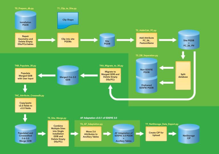
Migration Process
These Python tools were developed to automate the migration process and ensure no data was lost.

T0_Preparve_db.py
This tool checks the integrity of the geometry and repairs it if necessary. It also converts any multipart features to single-part features and deletes any empty datasets, feature classes, or tables.
T1_Clip_to_Site.py
Using a polygon chosen by the user, this tool clips an installation geodatabase into a site-only geodatabase. At this point, the user needs to considerw how to define the geographic extent of the site geodatabase. This is important, because in some cases a site is within another site. Also, it may be necessary to include non-AF features to provide situational awareness.
T2_AddnCalc_FC.py
This tool adds new fields to each v2.6 feature class for use later in the migration process. The new fields provide information in the v2.6–3.0 merged geodatabase to determine where the features in a v3.0 feature class were previously stored in the v2.6 geodatabase. This is necessary because, in some cases, multiple v2.6 feature classes are merged into one v3.0 feature class.
T3_DB_Separation.py
To retain those v2.6 feature classes that are not migrated to v3.0, this tool saves any such feature classes to the Orphaned geodatabase. To ensure a lossless migration, any data not v2.6 compliant is stored in the non-SDSFIE geodatabase.
T4A_Migrate_to_30.py
This tool appends the geodatabase output from T2_AddnCalc_FC.py to the merged v2.6–3.0 geodatabase.
T4B_Populate_30.py
From user-specified input, this tool populates required fields in the merged geodatabase with site-specific information.
T4C_Attribute_Crosswalk.py
This tool operates on the merged v2.6–3.0 geodatabase to ensure that relevant data is not lost. For each feature class to retain important v2.6 data, some information is copied/pasted from the old v2.6 field into the corresponding new v3.0 field.
T5_Site_Merge.py
This tool merges all the site-specific geodatabases into an installation master v2.6–3.0 geodatabase.
T6_AF_Adaptation.py
Still working with the merged v2.6–3.0 geodatabase, this tool copies the v3.0 attributes to a v3.0-only geodatabase and the remaining v2.6 attributes are then saved as ancillary tables.
T7_NetStorage_Data_Export.py
Working with the v3.0 geodatabase, this last tool exports only common installation picture (CIP) feature classes to a geodatabase destined for the AF’s Novell NetStorage web server.

