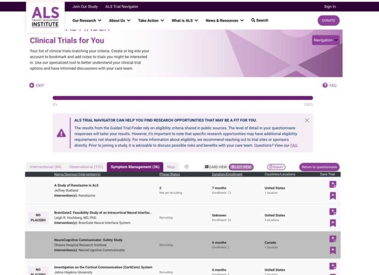
A nonprofit biotech organization, ALS Therapy Development Institute (ALS TDI), has partnered with Esri to help persons living with amyotrophic lateral sclerosis (ALS) more easily identify and potentially participate in ALS clinical trials.
ALS Trial Navigator launched in February 2024, brings an important dimension—geography—to the research that is being conducted on this devastating disease. ALS is one of a collection of motor neuron diseases that are characterized by the deterioration of motor nerve cells in the brain and spinal cord. Motor nerve cells control muscles. As these cells deteriorate, they no longer stimulate muscles, causing the loss of muscular strength and muscle control.

In the United States, ALS is often referred to as Lou Gehrig’s disease. Henry Louis Gehrig, a professional baseball player with the New York Yankees, was legendary for his durability and skill. His 17-year baseball career ended in 1939 when he developed symptoms and was subsequently diagnosed with ALS. He died in 1941.
Although ALS is more common in men than in women and its incidence increases with age, the majority of cases are considered sporadic with no clearly associated risk factors or links to family history. Approximately 10 percent of cases are genetic.
The probable life expectancy of persons diagnosed with ALS after the onset of symptoms is typically between two and five years. The rapid progression of the disease has made it problematic to conduct research not only to conquer the disease but also advance treatments that prolong and improve the lives of those living with ALS.
Location strongly affects participation in clinical trials because mobility and access are significant challenges for persons with ALS. Eligibility for participation in trials is often based on the time since onset of symptoms, so it is vital that trial information is current and readily available. The trial must be near enough to allow travel to the trial site.
“Location is everything for the chronically ill, and—amazingly enough—this information wasn’t mapped,” said Pat Dolan, an ALS advocate, GIS professional, former solutions team lead at Esri, and a person living with the disease.
The challenges Dolan personally experienced in obtaining treatment inspired him to apply his GIS expertise to the problem by building a web app that helps locate and rate nearby clinics. The app can be navigated using an eye-gaze device so it can be used by people with ALS as well as their caregivers.
“By having this information, it helps patients like me have a sense of hope and gives us the opportunity to put an action plan together,” Dolan said.
Dolan expanded his advocacy activities to urge members of Congress to support an updated version of the Accelerating Access to Critical Therapies for ALS Act (ACT for ALS). Collaborating with Amanda Stanko, senior solution engineer at Esri, he built a dashboard that monitored which lawmakers supported the bill and provided information on the number of veterans who lived in each congressional district. Some studies have suggested that military veterans are more than twice as likely to be diagnosed with ALS, according to the National Institute of Neurological Disorders and Stroke.
The team built a similar dashboard and app to enlist support from US senators. Their efforts were successful, and ACT for ALS was signed into law in 2021. This act requires the creation of a public-private partnership for rare neurodegenerative diseases that fosters research into drugs that improve or extend the lives of those living with ALS. That research is often conducted through clinical trials.
With legislation passed, Dolan turned to GIS-based efforts that would enhance its impact. He introduced developers at ALS TDI to Esri’s developer tools. ALS TDI, a 501(c)(3) nonprofit, is the world’s leading ALS drug discovery lab focused solely on ALS. Using Esri developer tools, ALS TDI built the ALS Trial Navigator to empower persons living with ALS and improve research results. It provides detailed information about trials that are located across the world, including each trial’s goal and duration, eligibility and exclusion criteria, and locations.
The ALS Trial Navigator can be used in two modes: map-centric or guided. The Trial Map shows the location of trials and information about them. The Guided Trial Finder uses a questionnaire to identify treatment priorities, explain research terms, and locate ALS clinical trials that meet the needs of a potential participant and the requirements of a trial.
Dolan sees this approach to trials as a game changer. Trials are designed to test the safety and efficacy of specific drugs or therapies, so participants in those trials need to match the conditions the trial was designed to evaluate. The ALS Trial Navigator tool helps people living with ALS understand the available clinical trial options and make informed decisions about their participation.
“Finding the nearest trials doesn’t do any good unless the trial is designed for your specific condition, genetic profile, and progression,” said Dolan. “This is why many trials fail.”
In addition to the ALS Trial Navigator tool, GIS continues to play a role in advocacy and research for people living with ALS. The ALS Geospatial Hub built using ArcGIS Hub, brings together data, stories, maps, organizations, and volunteers. Organized by geography, the site brings together data from federal agencies, research institutions, and nonprofit organizations.
The ALS Geospatial Hub is supported by a team of volunteers, known as The Mappers, who collect, analyze, map, and incorporate data into maps, apps, and ArcGIS StoryMaps. The Mappers are GIS professionals, ALS researchers, and ALS advocates.
There are numerous resources at the site. Apps for finding a clinic, adding clinic information, taking a survey, and viewing survey results are available. ArcGIS StoryMaps stories show patterns in access to care and the quality of care in the United States and around the world. A link to the National Amyotrophic Lateral Sclerosis (ALS) Registry lets persons with ALS provide information about their experience with the disease to aid research.
The ALS Geospatial Hub, like the ALS Trial Navigator, demonstrates how GIS is a powerful tool for improving treatment and research for the cure of ALS.

“The locations of clinics and trials are the first barrier to accessing care because patients are required to travel to the clinical trial site several times during it. What took us months to do, the Navigator can do in minutes.”


