For more than 50 years, the Arbor Day Foundation has developed relationships with organizations around the world to maximize the impact of planting trees. Focused on global reforestation efforts, urban forest management, and education about the importance of trees, the Arbor Day Foundation boasts over 1 million members, donors, and partners.
To effectively run the business of planting the right trees in the right places, the Arbor Day Foundation now relies on a robust ArcGIS Enterprise implementation to provide near real-time, accurate data for enhanced decision-making. Over the course of about a year, Esri partner Innovate! Inc. worked with the Arbor Day Foundation—exploring staff needs and organizational priorities—to develop a strategic plan for how to better deploy GIS. With its new, more robust GIS implementation, the foundation continually keeps staff and donors up to date on projects and priorities while showing concrete returns on investment for tree-planting endeavors.
Needs Assessments Inform Strategy
When the team at Innovate began collaborating with the Arbor Day Foundation, the organization was using ArcGIS technology on a limited basis, but it didn’t have an enterprise-wide GIS setup. Staff at the foundation were unsure where to begin or how to implement a fully developed geospatial solution to maximize their return on investment in Esri technology. The team from Innovate began by developing a strategic plan for how to deploy GIS within the organization, complete with short- and long-term goals.
Leaning on their deep experience in supporting nonprofits, Innovate staff designed transformative, cost-effective GIS solutions that enabled the Arbor Day Foundation to maximize donor engagement, streamline operations, and measure impact in near real time. These tailored solutions addressed the foundation’s unique needs, optimizing decision-making and project management.

By conducting a thorough needs assessment and engaging stakeholders from key departments such as business intelligence, corporate partnerships, IT, marketing, reforestation, and web development, Innovate ensured that every aspect of the Arbor Day Foundation’s diverse requirements was captured. The team translated this insight into actionable user stories and use cases; performed a data gap analysis; and developed a tailored product road map centered on geospatial data stored in the foundation’s ArcGIS Enterprise implementation, which is hosted in Microsoft Azure.
In close collaboration with foundation staff, the Innovate team integrated data from more than 20 systems across the organization, creating the basis for simplifying workflows and optimizing strategic decision-making. Innovate implemented ArcGIS technology and custom tools, delivered a robust system architecture, configured enterprise geodatabases, and modernized the organization’s reforestation processes. The Innovate team created dynamic dashboards and interactive widgets, enabling staff and donors to engage with impactful data visualizations.
With deep client engagement, expertise in ArcGIS products, and a commitment to fully understanding the Arbor Day Foundation’s vision, the Innovate team unveiled a wide range of previously untapped opportunities to integrate ArcGIS technology into workflows and processes.
A Dashboard Shows Impact
Corporate stakeholders increasingly prioritize environmental, social, and governance (ESG) goals. Yet aligning these objectives with impactful initiatives remains a challenge. For the Arbor Day Foundation, this means ensuring that reforestation projects meet ecological and social priorities while delivering tangible returns on investment for corporate donors.
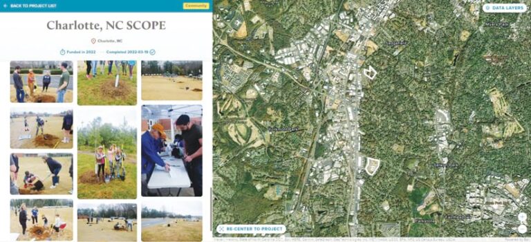
To this end, the Innovate team used ArcGIS API for JavaScript to create the Impact Dashboard, which displays accessible, visually compelling, and vetted scientific data on tree planting. Users can easily view transparent, near real-time data on the number of trees planted and any relevant environmental offsets—including the amount of carbon that gets sequestered and the number of pollutants removed from the air—and view the information on maps and in photos and stories.
For nonprofits, maximizing resource efficiency is a constant priority, and adopting digital tools is a crucial step toward achieving that goal. The Arbor Day Foundation recognized the need to modernize its manual processes, particularly those tied to donor reporting. These processes were labor-intensive and required significant staff time to gather, compile, and present data to corporate partners.
Previously, the Arbor Day Foundation took as many as 80 hours per donor to produce end-of-year reports, especially for large corporate donors such as Fortune 500 companies. Transitioning to a system that allows corporate partners to see up-to-date impact data through the Impact Dashboard reduced the Arbor Day Foundation’s administrative burden, enabling staff to focus on mission-critical tasks. These advancements also improved transparency and engagement, providing corporate partners with immediate access to visually compelling, data-driven insight without foundation staff having to manually generate reports. At any time, donors can see exactly what they’ve spent their money on, resulting in a feeling of tangible effect.
The Impact Dashboard proved impactful indeed. In addition to saving time and resources, the dashboard enabled the Arbor Day Foundation to put more money into its tree-planting initiatives. Conservative estimates indicate that the GIS integration and Impact Dashboard save the Arbor Day Foundation hundreds of hours of work and hundreds of thousands of dollars per year. With one tree costing $1 to plant, these savings directly affect and further the foundation’s mission.
The Initial Investment Pays Off
Innovate’s advanced integration of IT and GIS services provided the Arbor Day Foundation with powerful tools to elevate its mission to the next level. The organization’s initial $500,000 investment in updating its GIS has yielded savings that far exceed this expenditure, underscoring the transformative effects of engaging in strategic geospatial planning.
The data-driven donor reporting presented via the Impact Dashboard gives donors—including some of the most well-known telecommunications, beverage, car rental, and retail companies in the world—instant access to customized reports. Near real-time dashboards and storytelling tools such as ArcGIS StoryMaps have helped the foundation build more trust with its corporate donors and increase participation. This has enhanced transparency and reduced administrative overhead, saving the Arbor Day Foundation close to $500,000 annually on this process alone.
Moreover, by fully integrating GIS, the Arbor Day Foundation strategically expanded its efforts, leveraging data to identify and prioritize regions with the highest ecological and social return on investment across more than 60 countries.
Continued Collaboration as Technology Evolves
In support of the Arbor Day Foundation’s ongoing mission, Innovate continues to provide the organization with comprehensive services built on a foundation of high-level strategic planning, client engagement, and collaboration. This approach allows the Innovate team to deliver a full spectrum of enterprise GIS services, including traditional IT infrastructure support; the development of database systems; extract, transform, and load (ETL) processing; app modernization; the creation of custom widgets; and support for data analytics, data science, reporting, and training.
As Esri technology evolves, Innovate plans to leverage the ArcGIS ecosystem—including AI, machine learning, and 3D visualization—to develop even more customized solutions. Implementing software and apps such as ArcGIS Pro and ArcGIS Survey123 will help the Arbor Day Foundation engage in predictive modeling and mapping to prioritize reforestation efforts in areas of greatest need.
By integrating Esri’s technology with Innovate’s holistic approach to IT and GIS, the Arbor Day Foundation has enhanced its mission by delivering impactful environmental solutions while strengthening corporate partnerships. This collaboration underscores the power of GIS to drive meaningful, measurable change for nonprofits worldwide.


