Perhaps you’ve heard Esri president Jack Dangermond mention The Geographic Approach. It’s a phrase he often uses to describe his high-level vision for using geospatial technology as a key method in finding answers to problems.
“Geography, the science of our world, coupled with GIS is helping us [better] understand the earth and apply geographic knowledge to a host of human activities,” Dangermond says. “The outcome is the emergence of The Geographic Approach—a new way of thinking and problem solving that integrates geographic information into how we understand and manage our planet. This approach allows us to create geographic knowledge by measuring the earth, organizing this data, and analyzing and modeling various processes and their relationships. The Geographic Approach also allows us to apply this knowledge to the way we design, plan, and change our world.”
Solving problems using a geographic approach is not new. It is fundamental to the way geographers study and analyze our world. The concept is perhaps best articulated by Ian L. McHarg in the 1969 book Design with Nature, in which he details the philosophical context for managing human activities within natural and cultural landscapes.
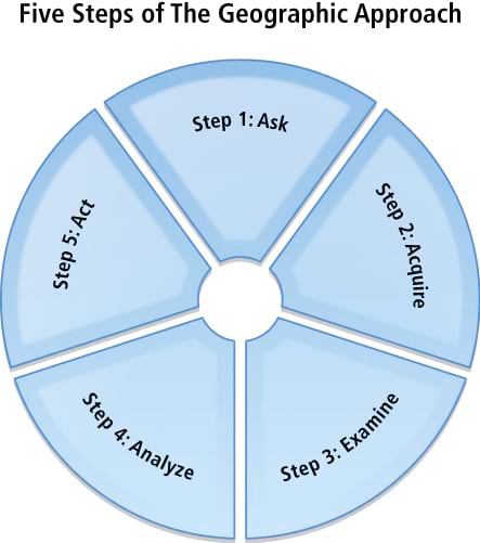
As a methodology, The Geographic Approach is used for location-based analysis and decision making. GIS professionals typically employ it to examine selected geographic datasets in detail, which are combined for the comprehensive study and analysis of spatial problems. This methodology parallels the well-known scientific method and includes a research-focused, iterative process for examining diverse datasets and uncovering potential solutions. GIS augments the analytic process, helping give people a clearer understanding of complex problems that often include geographic components. This in turn allows better decision making and more opportunities to conserve limited resources, as well as improves the way we work. Many experienced GIS professionals intuitively begin their projects with a structured methodology of this nature. But for those new to GIS technology, these five steps will provide a defined and proven approach.

Step 1: Ask
Approaching a problem geographically involves framing the question from a location-based perspective. What is the problem you are trying to solve or analyze, and where is it located? Being as specific as possible about the question you’re trying to answer will help you with the later stages of The Geographic Approach, when you’re faced with deciding how to structure the analysis, which analytic methods to use, and how to present the results to the target audience.
Step 2: Acquire
After clearly defining the problem, it is necessary to determine the data needed to complete your analysis and ascertain where that data can be found or generated. The type of data and the geographic scope of your project will help direct your methods of collecting data and conducting the analysis. If the method of analysis requires detailed and/or high-level information, it may be necessary to create or calculate the new data. Creating new data may simply mean calculating new values in the data table or obtaining new map layers or attributes but may also require geoprocessing. Sometimes you might have to consider using surrogate measures, which allows data creation through indirect means. For example, an economic indicator can be used as a surrogate for income. However, because of the limits in collecting accurate data in this way, it is necessary to indicate in your results the manner in which the data was collected.

Step 3: Examine
You will not know for certain whether the data you have acquired is appropriate for your study until you thoroughly examine it. This includes visual inspection, as well as investigating how the data is organized (its schema), how well the data corresponds to other datasets and the rules of the physical world (its topology), and the story of where the data came from (its metadata). Since the data ultimately selected for your analysis depends on your original question or questions, as well as the results that you are seeking and how those results will be used, your examination may be dependent on how precise the data must be to answer the original questions. Because data acquisition can be the most expensive and time-consuming part of the process, it is important that you begin with a well-defined data model for your organization and your project. This will provide the basis for evaluating potential data acquisitions.
Step 4: Analyze
The data is processed and analyzed based on the method of examination or analysis you choose, which is dependent on the results you hope to achieve. Understanding the effects of parameters you have established for the analysis, as well as the algorithms being implemented, is critical so that you can correctly interpret the results. Do not underestimate the power of “eyeballing” the data. Looking at the results can help you decide whether the information is valid or useful, or whether you should rerun the analysis using different parameters or even a different method. GIS modeling tools make it relatively easy to make these changes and create new output.
Step 5: Act
The results and presentation of the analysis are important parts of The Geographic Approach. The results can be shared through reports, maps, tables, and charts and delivered in printed form or digitally over a network or on the Web. You need to decide on the best means for presenting your analysis. You can compare the results from different analyses and see which method presents the information most accurately. And you can tailor the results for different audiences. For example, one audience might require a conventional report that summarizes the analyses and conveys recommendations or comparable alternatives. Another audience may need an interactive format that allows them to ask what-if questions or pursue additional analysis. Yet another audience may simply need to know how the results affect them or their interests.
The Geographic Approach provides the necessary framework for GIS analysis and helps ensure accurate, verifiable results. By carefully documenting, archiving, and sharing your results and methodology, other researchers receive the opportunity to verify your findings. This practice, called full disclosure, also allows statistical measures of the reliability of this data to be established.
Clearer Understanding of Results
Using a methodology such as The Geographic Approach formalizes the analytic process with GIS, which allows a clearer understanding of the results and promotes a response that can be supported by the data. By applying The Geographic Approach to help us solve complex problems, we can make better decisions, conserve resources, and improve the way we work.

