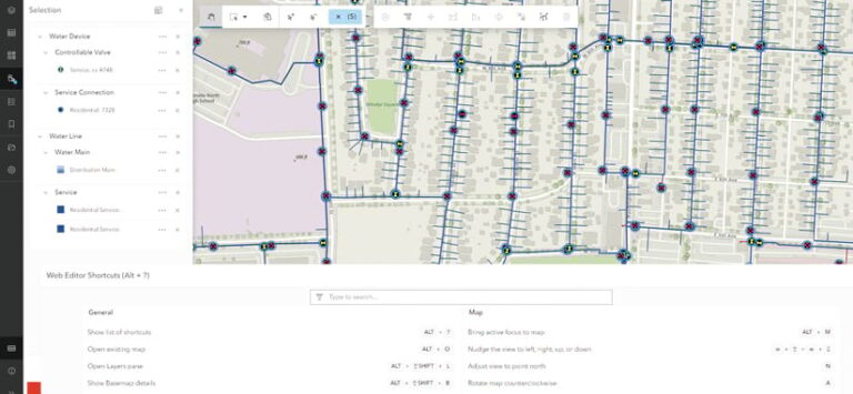
Easier, faster, better—that’s the promise of Esri’s new focused app for data editing, ArcGIS Web Editor. Users can edit and maintain data more easily, get data changes into the system more quickly, and do all that with fewer errors and higher precision.
Web Editor is included with ArcGIS Online and ArcGIS Enterprise, and its purpose is to simplify data editing activities and scale them within an organization. Although the web editing capability is not new to ArcGIS, it hasn’t had the completeness, robustness, or performance that ArcGIS Web Editor brings. Additionally, this new app is a leading feature of a larger strategy at Esri to advance web editing capabilities across the ArcGIS system.

Benefits for All Types of GIS Users
In recent years, data editing in the desktop and mobile environments has advanced considerably, yet many organizations have not taken full advantage of the web pattern of data editing. This is especially true for complex features such as networks, fabrics, topology, dimensions, and versioning. Using Web Editor can change that.
ArcGIS Web Editor is a self-service spatial data editing app that brings common tools for editing into one browser-based interface and guides users through the editing process. It modernizes data maintenance operations, reduces data errors, ensures a more accurate system of record, and enforces organizational data standards.
For GIS administrators and IT managers, installing and upgrading software on each user’s machine is largely becoming a thing of the past. Web Editor is deployed once in ArcGIS Online or ArcGIS Enterprise, and then all users can immediately access the most current software and app configurations on their computers from various work locations, whether they’re in the office or out in the field.
Many asset owners aren’t very technical, and they shouldn’t have to know GIS at a professional level to be able to do their jobs. Some biologists, for example, just need to delineate wetland boundaries, and many surveyors just need to enter parcel boundaries. These users expect simplicity from their apps, and that’s what Web Editor provides. For asset owners, it has a simple, focused, and targeted user experience with built-in context, onboarding, and user guidance. This makes it quick and easy for biologists, surveyors, and others to make the types of data edits they need.
For GIS analysts who correct data and perform quality control on it, these processes typically take a lot of time. Using data constraints and feature forms at the point that data is captured—rather than during post-capture validation processes—can cut down on much of this data correction work. And that’s where ArcGIS Web Editor comes in. It enables the autopopulation of values, enforces attribute rules, constrains values to ranges or lists, and maintains feature connectivity and coincidence. Through Web Editor, GIS analysts can also configure and expose these capabilities for the entire organization, saving everyone time; improving accuracy; and, when applicable, increasing safety for users in industries such as utilities.
Editing Data with Confidence—and Fewer Errors
ArcGIS Web Editor allows users to be more self-sufficient by enabling them to enter their data on their own, directly in the app. It adds contextual information needed during the editing process, such as related overlay data layers, and will soon include predefined tasks for following workflows, as well as descriptions of what to consider during the editing process. This all provides users with a guided experience so they can add and edit their data with confidence. The app also minimizes the editing options that are available, which prevents confusion.

GIS administrators can make their work lives easier by spending a little extra time defining and configuring Web Editor and its data rules. They can optimize the structure, timeliness, completeness, and consistency of the data contained within the app. These guardrails are then kept in place with attribute rules, feature forms, topology, and more. This staves off potential mistakes and reduces users’ reliance on the GIS team to correct data errors. It also gives GIS professionals more time to focus on other mission-critical activities.
Putting Data Editing at the Forefront of the User Experience
In its first release in ArcGIS Online and ArcGIS Enterprise, the Web Editor app provides users with a better editing experience overall. It comes with basic, out-of-the-box editing tools, including a better data selection experience to curate specific features, plus some foundational geometry drawing tools such as Freehand, Right Angle Line, Move, and Reshape. The app also leverages attribute rules and feature forms—platform-based approaches that are already established across ArcGIS apps and services.
The Web Editor app helps organizations leverage data editing and management capabilities by providing a consistent editing experience whether these capabilities are exposed through focused apps, widgets, or custom apps. And this is part of a larger, system-wide approach to elevating web editing across ArcGIS technology.
Although ArcGIS Web Editor is the premier app for editing data on the web and has the most capabilities for editing data, Esri is also delivering these same updated data editing tools throughout ArcGIS and at the developer tier—in low-code configurable apps, such as ArcGIS Experience Builder, as well as in ready-to-use apps like Map Viewer. All ArcGIS web apps have the same underlying web editing components, so they all benefit from these updates and improvements.
Enhancements like these bring consistency to the ArcGIS experience, meaning that editing tools work the same when used in different apps. The iconography, tool names, terms, and keyboard shortcuts are all the same. This enables users to stay comfortable and edit their data confidently, even when transitioning among different apps.
The ArcGIS Web Editor Road Map
As with many Esri products, ArcGIS Web Editor will gain more functionality over the coming months and years. The goal of the first two releases is to set a fundamental framework for the many releases and tools to come, so right now, Web Editor gives users access to core editing tools and feature forms. Once that framework is established, users will be able to create and deploy app configurations, edit utility network and parcel fabric data, assign tasks, work with client-side topology, and more.
ArcGIS Web Editor is available as part of ArcGIS Online and ArcGIS Enterprise (version 11.3). To use Web Editor, users need to have a Creator user type or higher. To leverage advanced features such as utility network or parcel fabric data editing, users will need to have a Professional user type or higher.
So go try ArcGIS Web Editor. And if you’re so inclined, please submit feedback about the app on Esri Community.

