With the Esri Redistricting Solution, the State Increased Transparency of Revising Legislative Boundaries
Redrawing representative districts in the United States is a contentious process fraught with acrimony. Because of the political influence at stake, the exercise regularly leads to allegations of unfairness. Nevertheless, after each US Census is taken, states must examine—and potentially redraw—their congressional districts.
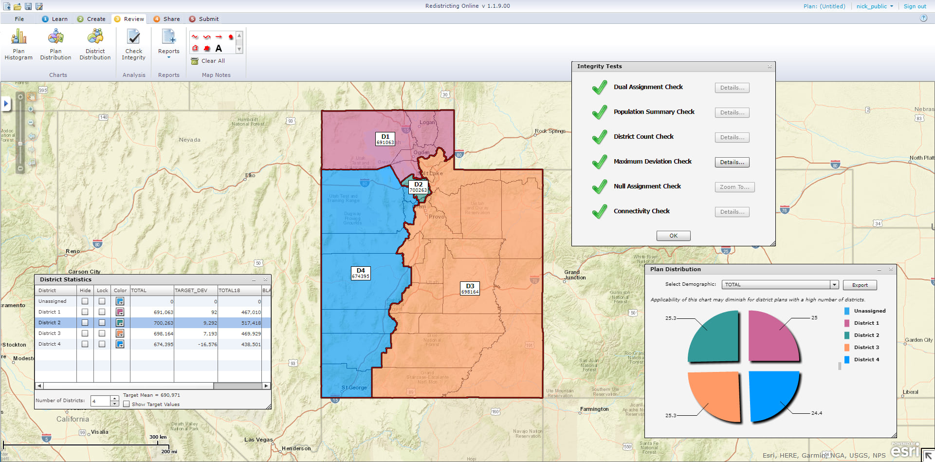
For the last round of redistricting in 2011, the State of Utah took a novel step toward mitigating criticism: its Redistricting Committee made the process much more transparent to better educate citizens about how it works. Using the Esri Redistricting solution, the committee opened up the proceedings to the public, revealing all the intricacies involved in redistricting and displaying the many genuine obstacles to formulating a solution that satisfies everyone.
Opening Up Redistricting
Following the 2010 US Census, Utah, like all other US states, had to reconsider how its congressional districts were split up. State legislators wanted the public to be involved in the process, but online district mapping tools hadn’t been available in prior redistricting years.
Late in the planning stages of its 2011 efforts, the state’s Redistricting Committee saw a demonstration of Esri’s Redistricting solution and decided to implement it. This would allow citizens in Utah to create and submit their own statewide redistricting plans online.
Working with Esri, legislative staff customized the solution slightly to ensure that users drew their redistricting plans according to the same requirements the state legislature had to meet. Shortly after rolling out the public-facing solution, the committee also created a companion website that allowed citizens to explain their plans and comment on those from others.
As legislators and analysts drew legislative boundaries for the state using Esri partner Citygate GIS’s AutoBound extension for ArcGIS Desktop, citizens all over Utah were able to go online to create their own maps for congressional, legislative, and state school board districts.

“This was the perfect citizen engagement opportunity,” said Richard Leadbeater, the industry solutions manager for state government at Esri. “Opening up the process of redistricting to citizens helped people realize that redistricting is hard. They got to see that it’s difficult to start with a specific idea for your city and then come up with a fair, equitable plan for the entire state.”
Creating New Solutions
Citizens accessed the Esri Redistricting app via a web browser, where, with a user name and password, they could either create new plans or collaborate and edit existing ones.
To make a new plan, users first selected census-designated geographic areas of varying sizes, such as counties or groups of neighborhood blocks. Indicators and reports within Esri Redistricting allowed users to visualize the demographic breakdowns in each of their proposed districts and see what would happen if they made changes to their plans.
In addition to mapping out their own redistricting solutions, users could create online groups to share and modify their plans. They could also use the companion website to make public comments about the pros and cons of various plans.
When users considered their plans complete, they locked them to prevent any further revisions and submitted them, via the app, directly to the Redistricting Committee for review.
Legislators also opened up the process to members of the media, since that tends to be where a lot of criticism comes from. Journalists were able to use the same computers and desktop tool that legislators employed to create plans of their own, and legislators were present to answer any questions they had. This way, members of the media were able to get a better understanding of how redistricting works.
Even More Transparency
A thousand citizens registered to use the site and submitted a total of 323 plans. Of those, 271 met the criteria for completeness, which included having each district be as equal as possible in population count, as well as contiguous and relatively compact.
The committee held 17 public meetings throughout the state so legislators could get more public input on redistricting and make the process even more transparent. Citizens who had submitted plans were invited to attend these meetings to discuss their ideas in person.
“If someone who created a plan came to a public hearing, we could bring their plan up online and project it on a screen where everyone could see it,” said Jerry Howe, the managing policy analyst for the Utah State Legislature. “They could then discuss their plan and make arguments for it.”
There was a plan for the state school board drawn by a member of the public that, with some minor modifications, was adopted.
A Smoother Process
Even though there were still disagreements during the 2011 redistricting process, the Esri Redistricting solution provided the public with unparalleled visibility into how it works, and the Redistricting Committee got unprecedented access to what Utah’s citizens wanted. According to Howe, participants not only gained an appreciation of how drawing statewide congressional boundaries works, but legislators also received a variety of options to consider.
“The plans [citizens] drew were helpful,” Howe commented. “There was a plan for the state school board drawn by a member of the public that, with some minor modifications, was adopted.”
Howe believes that public participation in redrawing Utah’s state districts was beneficial to the overall redistricting process.
“I think the public and the media understood the problem better after using the Esri tool,” he said. “It eliminated some criticism that was unfounded. Everyone who submitted a complete plan learned that it is really easy to draw the first part of the plan—but the real lesson everyone learned was that it gets really difficult to draw the final districts without harming compactness, city and county boundaries, and communities of interest.”
For more information about how Utah employed the Esri Redistricting solution in 2011—and how it plans to use the tool after the next US Census—email Howe at jdhowe@le.utah.gov. Learn more about Esri Redistricting.

