More than 100 million years ago, North America consisted of two landmasses separated by a giant inland sea—the Western Interior Seaway, which connected the Arctic Ocean to the Gulf of Mexico. Today, along with a plethora of marine fossils strewn across the Great Plains, vestiges of this ancient sea include a handful of inland saline wetland areas, with groundwater pickled by underground salt deposits from evaporated seawater.

Wetlands are important for wildlife habitat, water quality, flood protection, erosion control, recreation, and aesthetic value. Inland saline watersheds have additional conservation concerns due to their environmentally unique ecosystems and the many endangered species that rely on them.
Some of these inland saline wetlands lie in eastern Nebraska’s Little Salt Creek watershed near the state’s capital city of Lincoln, about 1,000 miles (1,609 kilometers) from the nearest ocean. They are home to many unique or endangered plant and insect species, such as the federally protected Salt Creek tiger beetle. The wetlands cover only about 4,000 acres (approximately 16 square kilometers)—down from about 20,000 acres (about 81 square kilometers) prior to European settlement—and much of the habitat has been degraded or lost due to factors such as urban development, levee construction, and stream-channel straightening.
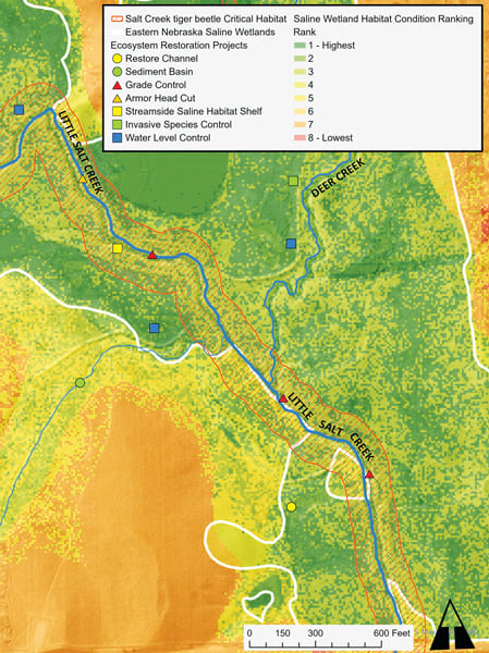
Many of this area’s current, former, and potential saline wetland areas are now being protected and restored with help from ArcGIS technology. By applying ArcGIS Pro, the Arc Hydro Wetland Identification Model (WIM), and several ArcGIS apps, water resources engineering consulting firm The Flatwater Group (TFG)—together with wetland managers from the Saline Wetlands Conservation Partnership—developed 120 ecosystem restoration project plans for this area, known as Nebraska’s eastern saline wetlands.
ArcGIS StoryMaps Story Helps Launch a Watershed Plan
Formed in 2003, the Saline Wetlands Conservation Partnership includes the City of Lincoln, the Lower Platte South Natural Resources District, the Nebraska Game and Parks Commission, and Pheasants Forever. With funding from the Natural Resources Conservation Service’s Watershed and Flood Prevention Operations program, TFG and the partnership developed an environmental assessment as well as restoration project plans that will address erosion, control sediment, stabilize streams, and more.
To raise awareness and educate the public about Nebraska’s eastern saline wetlands, their financial value, and their importance to local ecosystems, the partnership held a virtual public meeting in 2021 that featured an ArcGIS StoryMaps story and an interactive app made with ArcGIS Web AppBuilder. The meeting’s presentation outlined the planned conservation approach and the need for ecosystem restoration and protection in Nebraska’s Little Salt Creek watershed. The story and the app also facilitated required functions for the project, such as soliciting public comments.

From Data Inputs to Spatial Analysis
The partnership and TFG evaluated the Little Salt Creek watershed’s saline wetlands and habitats using ArcGIS Pro, Arc Hydro WIM, and GIS datasets. They considered vegetation, soil, and hydrology—the three factors that can determine whether an area is a wetland or has the potential to become one.
For vegetation, TFG engineers and scientists enhanced data from the US Geological Survey’s 2011 National Land Cover Database with saline wetland categorization maps. For soils, they referred to the Natural Resources Conservation Service’s Soil Survey Geographic Database. For hydrology, they used the Arc Hydro WIM, which predicts wetland locations using lidar elevation data and machine learning, along with a surface water raster to develop a depth-to-water index and predict specific areas’ suitability for restoration or other actions.
When combined using a raster matrix, the vegetation, soils, and hydrology data helped generate saline wetlands restoration suitability rankings. This included a map that facilitated a first-of-its-kind functional assessment for saline wetlands—something that’s needed to do a federally required economic cost-benefit analysis.
As these restoration projects proceed, planned operations and maintenance phases will employ the same ArcGIS tools to assess the projects’ benefits. Drone photography, multispectral imagery, and lidar data will be used alongside ArcGIS software to enhance monitoring and track site changes, such as the boundaries of groups of native and invasive vegetation. After implementation, the projects will provide the next chapter in the protection and restoration of Nebraska’s eastern saline wetlands.


