In Singapore, the Urban Redevelopment Authority (URA) is responsible for urban planning in the city-state. With the goal of making Singapore a better place to live, work, and play, the URA regularly provides core foundational training to the organization’s planners and architects to give them an in-depth understanding of cutting-edge urban design techniques and sensibilities.
This training typically requires participants to collaborate in groups on an urban design project. They’re given a site and a design brief that tasks them with developing a well-considered proposal that accounts for surrounding land use, the streetscape, the area’s heritage value, topography, the environment, transportation networks, and community needs. At the end of the course, teams present their projects for discussion in both 2D and 3D, complete with concept sketches, drawings, and physical models.

The onset of the COVID-19 pandemic, however, meant that the traditional approach to training—which includes in-person workshops and requires teams to build physical models for critiquing—would no longer be viable. By mid-2020, the majority of people in Singapore were working from home. Determined to continue and improve its training program, URA’s training team opted to digitally transform its courses to an online format where participants could collaboratively develop, share, and evaluate their urban design projects. ArcGIS Pro was key to executing this plan.
ArcGIS Pro Takes On a New Role
To ensure that the program could continue virtually, members of URA’s training team explored alternatives to their traditional approach. They decided to keep the same course requirements but pivoted to a digital approach. They needed a technology solution that allowed participants to collaborate, incorporated 2D and 3D data, and was easy to implement.
“[The] capability [of ArcGIS Pro] to work with both 3D and 2D data made it a great choice for us,” said Julian Cheng, executive architect at URA’s Design and Planning Lab. “There was also no need to specifically deploy additional 3D software to the participants, as ArcGIS Pro was already used and deployed across the organization as our main GIS software.”
Indeed, what proved vital to the new training program was staff members’ experience in leveraging advanced GIS technology across a range of sophisticated urban planning workflows. When they needed to swiftly transition to remote work, employees could still access URA’s geospatial data from anywhere, anytime they needed it.

[Participants] quickly realized how much more they could do with ArcGIS Pro as opposed to working with physical models alone.
Having already digitally transformed workflows across the organization in previous years, URA’s training team was familiar with conducting courses virtually and incorporating ArcGIS Pro into the curriculum. Many participants had also used the technology in other analytical training courses in which ArcGIS Pro is taught as the main software.
Digital 3D Models Produce Richer Detail
In September 2020, the URA training team launched its first virtual urban design course.
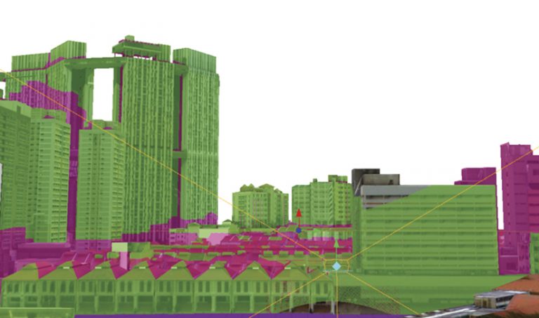
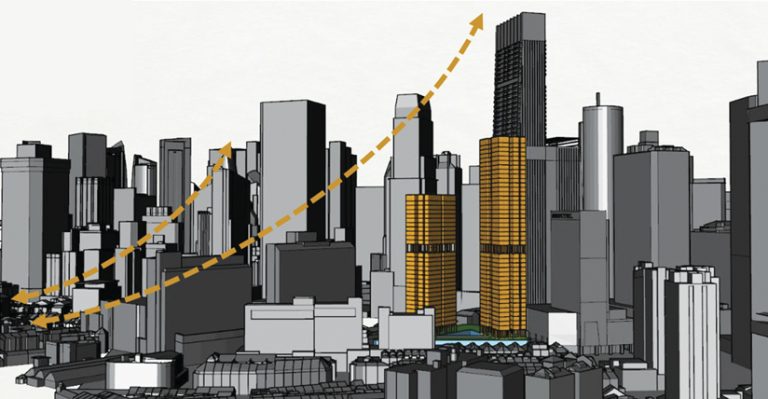
To begin, participants were brought up to speed on working with 3D models in ArcGIS Pro so they could use it effectively to convey their design ideas. URA also provided participants with an existing 3D digital model of Singapore that they could import into ArcGIS Pro. This helped participants visualize and analyze how their designs would fit into the real world.
“They quickly realized how much more they could do with ArcGIS Pro as opposed to working with physical models alone. For example, participants learned how to conduct 3D analyses, such as shade, solar, and viewshed simulations, to test out and explain their urban design proposals in a more visual and data-informed manner,” said Cheng. “By integrating existing 3D digital models—including those from other platforms—with our 2D GIS datasets and pushing boundaries of other 3D technologies, including [ArcGIS] CityEngine, we were able to enhance our urban planning training and develop new workflows for greater efficiencies and effectiveness.”
Members of the training team noticed that by changing from physical models to ArcGIS Pro simulations, participants created design plans richer in detail and more comprehensive than those produced using the previous, more traditional approach.
Virtual Becomes the New Normal
As of September, URA has conducted two urban design courses remotely. In total, approximately 60 participants have built their 3D designs in ArcGIS Pro and have developed a more comprehensive understanding of urban planning technology.

The collaborative workflows established through this training program are set to become the norm for future training and urban planning projects at URA. According to Cheng, the training team is in the process of finding more ways to incorporate ArcGIS Pro across courses.
“We have conducted three runs of another internal vocational training course virtually, using ArcGIS Pro to build efficiency in the use of spatial data and analytics for urban planning work,” he explained.
Through these additional programs, more than 80 participants have done virtual learning at URA in 2020 and 2021.
“To facilitate continuous learning, we have also published some self-paced e-Learning content, which we will continue to build up and supplement over time,” said Cheng.
As the training team looks toward a postpandemic future, virtual 3D models will continue to be a core aspect of courses that help planners and architects learn to make smart planning decisions.
“After the pandemic, the course will have a mix of virtual as well as in-person sessions to facilitate interactions, discussions, group work, and hands-on activities,” said Cheng. “We will continue to develop competencies in using ArcGIS Pro—together with other digital tools, such as parametric design and environmental simulation tools—to enhance our work.”
By digitally transforming its design courses and conducting this training program remotely, URA can improve the skills of more urban planners and architects throughout Singapore. Those who complete this new method of training will be able to leverage the latest technological capabilities for urban design, including geographic building information modeling (BIM), 3D digital twins, and smart city planning.
URA’s trailblazing use of modern urban planning technology will ensure that today’s decisions will make Singapore a livable and sustainable city for future generations.

