GIS Assessment Model Uncovers Optimal Sites for Renewable Energy Production
It’s predicted that the province of British Columbia (BC), Canada, will require an additional 30,000 gigawatt-hours of electricity within the next 20 to 25 years. To meet this projection, BC Hydro retained consulting firm Kerr Wood Leidal Associates Ltd. (KWL) to conduct a hydroelectrical analysis and identify optimal sites for run-of-river power development.

Because stream flows vary from month to month, many variables must be considered to accurately target reliable sites. These include surface runoff; seasonal changes in streamflow; and terrain characteristics such as slope, elevation drop, and proximity of sites to existing power lines and access roads.
Traditionally, data would be collected and analyzed by inspectors using paper and topographic maps. However, manual data collection over large areas can take years to complete and can be ineffective for locating sites in remote areas. As such, KWL needed to develop an automated process to identify potential sites for run-of-river power development both quickly and cost-effectively.
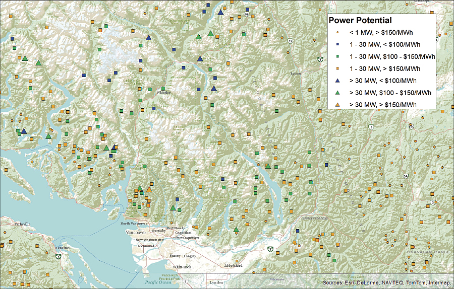
In response, the firm used the ArcGIS Spatial Analyst extension to build a Rapid Hydropower Assessment Model (RHAM) that automates the process of site selection. Using algorithms, the model can estimate a site’s potential power output by combining factors such as a stream’s flow and the elevation differential between the water intake and the turbine in the powerhouse. Power potential information was gathered for more than 10 million sites in BC and saved as a vector data layer in ArcGIS for Desktop.
Once these sites were identified, data was screened for parameters suitable for run-of-river power development. Areas considered “no-go zones,” such as parks or salmon streams, were removed, and an optimization process was applied to further narrow results based on energy output relative to infrastructure required.
“Through GIS, we were able to collect data on more than 10 million potential sites in a matter of hours—a process that traditionally would have taken years,” says Ryan Taylor, GIS administrator, KWL. “We were also able to target locations that were off the beaten path and would have never been discovered.”
Regional hydrology analysis was also carried out to develop an estimate of energy production by region. This involved statistically analyzing hydrological data from Water Survey of Canada and distributing resultant statistics to the remaining project locations. Using conventional cost estimating, data modeling, and ArcGIS, KWL then developed estimated production costs for each site.

Unit energy costs were also predicted by combining the estimated energy production with annual and operating expenditures. Also considered were social and environmental factors, such as the number of jobs that could be created and the geographic size of the area that would be affected by each potential project.
Through the GIS-based Rapid Hydropower Assessment Model, KWL identified more than 8,000 sites in the province that could be developed as run-of-river power projects. It also predicted how power output could fluctuate throughout the year based on regional variability factors that might create changes in streamflows.
To ensure project viability, GIS was used to create cost estimates for access roads and power lines and identify the least expensive routes to hydropower sources. Cluster analysis was used to reveal sites that could potentially share road networks and transmission lines while identifying remote areas that would benefit from the construction of new infrastructure.
These sites have a potential installed capacity of more than 12,000 megawatts and could generate nearly 50,000 gigawatt-hours of energy per year. By calculating unit energy costs, KWL was also able to highlight projects that would be the most cost-effective to pursue and discovered 121 potential sites within BC where energy production would cost less than $100 per megawatt-hour.
Given the success of the project, KWL will use the Rapid Hydropower Assessment Model to help other communities, including First Nations groups, develop renewable energy projects and transition away from reliance on diesel generators.
For more information, contact Ryan Taylor, GIS administrator, Kerr Wood Leidal Associates Ltd..

