A recent influx of funding to deploy broadband more equitably throughout the United States—including more than $42 billion in investment from the National Telecommunications and Information Administration—has accelerated demand for high-speed internet infrastructure across the country. This funding surge has also increased demand from telecommunications companies to implement efficient and accurate solutions that can help manage increased workloads and meet project timelines.
Sioux Falls, South Dakota-based telecommunications engineering company Geosolv serves a diverse clientele, including urban developers and rural broadband providers. To assist its clients in tackling the current rush of new infrastructure projects, Geosolv starting using an advanced reality capture platform from Esri partner GeoCam, along with ArcGIS products such as ArcGIS Pro and ArcGIS Online, to optimize the planning, design, and deployment of fiber-optic networks.

Data Collection Presents a Host of Challenges
Until recently, Geosolv faced significant challenges in its fiber network planning processes—particularly in capturing accurate field information, given the company’s limited field resources and the costs associated with mobilizing them. Traditional data collection methods were time-consuming and resource intensive, often requiring mobile staff to conduct extensive field-based surveys and perform manual data entry. This delayed project timelines and raised operational costs.
Because the company relied on manual data collection methods, it was difficult to capture accurate information in the field, raising the risk of inputting errors and having incomplete information. Geosolv’s small team of field surveyors collects data in various urban, suburban, rural, and indoor environments, which often requires the team to use specialized equipment and approaches, further straining the company’s resources. Factors such as transportation and having to conduct repeat visits also puts a strain on the company, especially when it comes to surveying remote or difficult-to-access locations.
Upgrading Fiber Network Planning Workflows
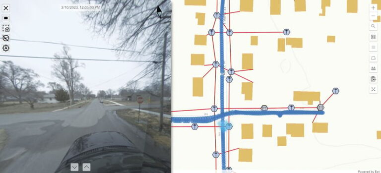
To address these challenges, Geosolv turned to GeoCam’s advanced reality capture platform. This integrated system—which is customized for utility and telecommunications users—includes a 360-degree camera that can be deployed on vehicles, drones, and backpacks to capture high-resolution imagery across diverse terrain. The platform’s visual positioning system and AI models automate feature identification and creation, expediting highly accurate infrastructure data collection and system distribution mapping.
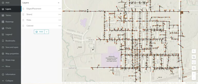
GeoCam integrates with ArcGIS Online and ArcGIS Pro—two core components of Geosolv’s toolkit—via GeoCam Manager and GeoCam Editor. GeoCam Manager helps administrators set up reality capture projects, establish users, and configure the cameras. Once captured data is added to ArcGIS Online and ArcGIS Pro via GeoCam Manager, GeoCam Editor streamlines map creation, enabling users to auto-assign feature types—such as poles, pedestals, homes, and fiber infrastructure connections—using single-click mode and smart symbol detectors. Users can also triangulate feature locations by comparing two image views, which increases accuracy.

Geosolv implemented GeoCam QAQC as well, a robust quality assurance and quality control process that helps ensure data integrity. It allows users to review, flag, and correct data inaccuracies in ArcGIS Online and ArcGIS Pro. Additionally, the company implemented GeoCam Viewer to simplify users’ interactions with imagery and GIS data. The app allows stakeholders to easily navigate maps, search for features, and collaborate on web maps via shareable URLs.
Experiencing Operational Efficiency and Cost Improvements
Implementing GeoCam’s advanced reality capture platform and ArcGIS technology has improved data collection, processing, and mapping operations at Geosolv, boosting field data collection efficiency by 60 percent. This enables the company to cover more ground in less time while cutting down on errors. Not only has this enhanced data accuracy, but it has also allowed Geosolv to design more networks with higher data quality. The automated processes that are part of the GeoCam experience have also expedited project timelines, enabling Geosolv to meet tight client deadlines. Fewer revisions are needed, and operational costs have been slashed, giving Geosolv a competitive edge in the fast-paced telecommunications industry.
Geosolv’s adoption of GeoCam’s reality capture platform alongside Esri technology has significantly enhanced the firm’s capabilities in fiber network planning. The implementation not only addresses current industry challenges but also lays the foundation for future growth and innovation.
“The integration of GeoCam and Esri technology has totally transformed Geosolv’s approach to fiber network planning,” said GeoCam CEO Myles Sutherland. “They can now deliver more precise, cost-effective, and efficient solutions to Geosolv’s clients, setting a new standard in the telecommunications engineering industry.”


