When considering how land records are managed in the United States, the local tax assessor’s office may come to mind. Responsible for collecting taxes in their communities, assessors are stewards of important land information and property characteristics and often maintain maps of the parcels that make up their jurisdictions.
But what about the strips of land that lie in between taxable parcels? Often void of information or even nonexistent on tax maps, this land contains some of the United States’ most critical infrastructure, from transportation, water distribution, and sanitary sewer systems to electrical and communication networks. Sometimes hidden in plain sight, these ribbons of land are called right-of-ways, and they contain resources that help keep people throughout the United States connected.

With such important services at stake, many transportation agencies and utility companies are turning to GIS to manage right-of-ways. This is helping them boost efficiency, improve operator safety, inform design decisions, ensure compliance with standards and regulations, and be more resilient in the face of mounting weather extremes due to climate change.
Aging US Infrastructure Gets a Boost
In its 2021 Report Card for America’s Infrastructure, the American Society of Civil Engineers gave US infrastructure a below-average grade of C–. Thus, the United States needs to take swift action to avoid additional deterioration of its infrastructure and meet the growing needs of society.
It seems that the United States is heading in the right direction. With the passage of the bipartisan Infrastructure Investment and Jobs Act in 2021, the US government authorized spending $1.2 trillion to improve transportation and infrastructure throughout the United States. The White House then released the Biden-Harris Permitting Action Plan in May 2022, which aims to accelerate federal environmental review and permitting processes, and the Biden-Harris Action Plan for Accelerating Infrastructure in October 2022, which provides provisions to accelerate infrastructure construction. Both plans seek to leverage technology and innovation such as GIS to achieve their goals.
Moreover, as of October 2023, the US Department of Energy is investing nearly $3.5 billion in the country’s electrical infrastructure. This funding package, which aims to strengthen the resilience and reliability of America’s power grid, identifies 58 projects across 44 states that strive to improve systems and make energy more reliable and affordable.
Now more than ever, it is crucial to have readily accessible right-of-way information to plan transportation, electrical, and other types of infrastructure projects. For instance, by leveraging ArcGIS Parcel Fabric, which is supported by a flexible data model and scalable architecture, organizations can easily maintain and share accurate, up-to-date, and authoritative right-of-way parcel data. They can also significantly reduce the time it takes to plan new infrastructure projects by incorporating data layers from ArcGIS Living Atlas of the World and deploying extensions such as ArcGIS 3D Analyst and ArcGIS Spatial Analyst.
Digitizing and Georeferencing Documents
According to the Federal Highway Administration, a division of the US Department of Transportation, the United States has approximately 4.19 million miles of highway. Decades—and in some instances, even centuries—of land transactions carved out the right-of-ways for these highways.
Likely, the real estate division of every organization responsible for managing these right-of-ways has a records room filled with documents that define where critical infrastructure can be placed. However, these records—which are vital yet often difficult to access—are vulnerable to loss due to fires, floods, deterioration, and more. Additionally, doing research with these documents is often burdensome for agency personnel and adds costs to every infrastructure project because accessing them is usually a manual process.
At the Nevada Department of Transportation (NDOT), for example, right-of-way survey services manager Gregorio Torres faced a challenge like this. NDOT had a huge number of documents dispersed among many different folders, boxes, and filing systems.
“Information wasn’t consistent or reliable,” said Torres. “It hadn’t been brought together in a way that addressed all of the issues that the digitization process highlighted. We needed to change.”
So the department embarked on an ambitious project to digitize and map NDOT’s right-of-way documents in GIS. Now, teams across the organization have ready access to right-of-way information, which has greatly improved efficiency.
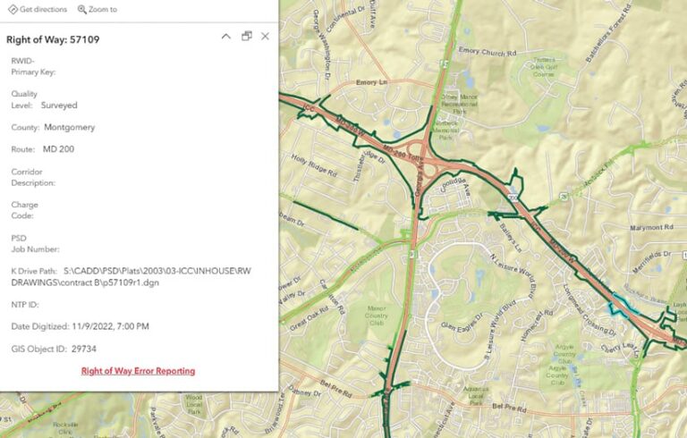
The Maryland Department of Transportation (MDOT) is also employing GIS to digitize its existing right-of-way plats. These maps show official land transactions and provide the historical records needed to plan and design Maryland State Highway Administration projects. Now, right-of-way data in Maryland is presented uniformly within MDOT’s ArcGIS Online environment as authoritative feature layers. This allows both internal MDOT users and members of the public to access right-of-way and associated plat information in a single location on the web.
Planning with Purpose
Once existing right-of-way records are mapped and accessible in GIS, officials can better plan expansion and reconstruction projects and build or rebuild more efficiently.

In the United States, there are about 5.5 million miles of electrical distribution lines and 600,000 miles of transmission lines, according to the National Academies of Engineering. By understanding where existing right-of-ways are located, agencies that manage this infrastructure can more easily identify environmental sensitivities, prohibitive construction conditions, and access issues that could affect a project. This can accelerate project timelines and save organizations money.
The Chugach Electric Association in Alaska, for example, uses GIS to keep projects on track during the utility’s very short, five-month construction window. ArcGIS Enterprise and Cityworks PLL—a solution from Esri partner Cityworks (a Trimble company) that’s built exclusively on ArcGIS technology—now contain all of the utility’s land permitting and right-of-way data. When staff members need to request right-of-way information, the process is automated. And it’s easy to share land records across the organization, which enables staff to plan construction projects more efficiently.
Staying Safe and Compliant
Not only is it imperative for organizations to know where their right-of-ways are, but it is also important for them to understand what lies within each right-of-way.
In the United States, there is currently a focus on colocating utilities—especially by putting broadband infrastructure within transportation corridors. This means there is an increased need to understand the exact location of assets and encroachments.
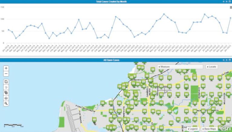
Given that the United States has more than 2.2 million miles of underground water infrastructure, an estimated 1.2 million miles of underground sewer lines, more than 2.6 million miles of natural gas and liquid petroleum pipelines, and millions of miles of electrical infrastructure, there’s plenty of opportunity for conflict. If utilities and transportation organizations map these assets in ArcGIS Pro and maintain them using tools such as ArcGIS Field Maps and ArcGIS QuickCapture, then staff members can quickly, easily, and securely share this data with key stakeholders via ArcGIS Dashboards or ArcGIS Online. That reduces the likelihood that conflicts will arise during a construction project.
Having a Lasting Impact
Overhauling the United States’ aging infrastructure is a daunting task, yet one that is essential for keeping the country connected and its infrastructure resilient. Using GIS to manage right-of-way records and their associated projects gives transportation organizations, utilities, and other companies a huge boost toward achieving this goal. And moving to location-intelligent, digital records will have a lasting impact for generations to come.
Learn more about managing right-of-ways with GIS.

