Esri and the Group on Earth Observations
Although we are well into 2021, we continue to deal with the specter of last year. The highest global temperatures on record were experienced in 2020, according to “Climate crisis: 2020 was joint hottest year ever recorded,” a 2021 article in The Guardian. Only 2016 was as hot, but that year included a significant El Niño warming event. Even with human activity in 2020 slowed by a global pandemic, data providers, such as the European Union’s Copernicus Climate Change Service, showed how drastically the face of the Earth continued to change as a result, putting the future of billions of people at great risk.
The clear danger—present and future—of climate change is still with us. One of the best ways that we can cope on a global scale is by continuous, near real-time mapping and monitoring of the entire face of the Earth. The Group on Earth Observations (GEO) is one of the most comprehensive collaboratives doing just that. This mini “United Nations” of governments and organizations, which includes Esri, is building the Global Earth Observation System of Systems (GEOSS).

In 2003, an initial group of 33 countries, including what was then the G8 convened at the Johannesburg Summit on Sustainable Development. [G8 or the Group of Eight was an intergovernmental political forum.] These government ministers (who were not scientists) recognized a growing and critical need for improved, near simultaneous observation of the entire planet, and developed a plan for a more coordinated Earth observing system.
GEO was established in February 2005 as a result of this summit. It has now grown to a membership of 112 countries plus the European Commission, along with 130 partners and 15 associate member organizations. The GEO Secretariat (which will be led by Yana Gevorgyan, beginning in July 2021) plays a leading role in coordinating and supporting a series of work plans for implementing GEOSS. These work plans build on national, regional, and global observation systems of airborne, space-based, and shipboard instruments, along with a growing network of environmental sensors on land and in freshwater lakes and streams.
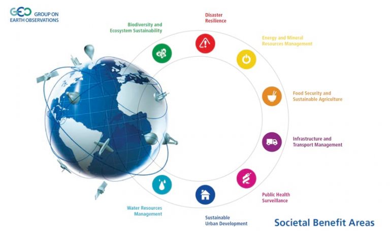
Not surprisingly, GEO is also deeply involved in the United Nations 2030 Agenda for Sustainable Development, the Paris Climate Agreement, and the Sendai Framework for Disaster Risk Reduction. As such, it seeks to address eight societal benefit areas where Earth observations can provide viable solutions to the planet’s challenges: biodiversity and ecosystems, disasters, energy and mineral resources, food security, public health, infrastructure and transportation, urban development, and water resources.
For the past several years Esri has been involved in a variety of GEO projects, including an effort since 2014 to broker various forms of Earth observation data and services between ArcGIS Online and the GEOSS Portal. This essentially gives ArcGIS Online subscribers the ability to share their data with the broader GEOSS community, and also discover and access the data services published to the GEOSS Portal by others.
Also, in 2014 GEO called for the development of a standardized, robust, and practical global ecosystems classification for all of Earth’s terrestrial, marine, and freshwater ecosystems. This incredibly ambitious mapping task became a key program within GEO Biodiversity Observation Network (GEO BON) and GEO Global Ecosystems Community Activity (GEO ECO). Roger Sayre of the US Geological Survey served as a US delegate to GEO. Under his leadership a terrestrial world ecosystems map, Global Ecological Land Units (ELUs), was developed at the unprecedented resolution of 250 meters as well as the Ecological Marine Units (EMUs), which provides baseline 3D mapped ecosystems of the ocean. Both were produced in close collaboration with Esri and a number of other partners. The work to fulfill GEO’s global ecosystems mapping vision continues with an Ecological Coastal Units project, which is underway, and will be followed by an Ecological Freshwater Units project. [For more information on these projects, see to the To Learn More section at the end of this article.]
Under the skillful coordination of Pat Cummens, Esri director of government strategy and policy solutions, Esri has risen to the status of a GEO Associate. This is a fairly new category that enables for-profit companies and national associations of commercial firms to participate in a non-governing but highly collaborative capacity within GEO. As a result, Esri is increasing its participation in GEO. Nearly 30 Esri staff members are taking part in many GEO programs.
At the highest level of GEO, Esri staff actively participate in GEO BON, a GEO Flagship programs, and 6 of the 19 GEO Initiatives, including the GEO Global Water Sustainability (GEOGloWS) and Oceans and Society: Blue Planet (GEO Blue Planet) initiatives.
For example, since 2015, under the auspices of GEOGloWS, Steve Kopp has led Esri’s involvement in a collaboration with Brigham Young University, the European Center for Medium Range Weather Forecasting (ECMWF), and others in a quest to provide global streamflow forecasts. This global stream flow service is wrapped in a web map featuring updated hydrologic modeling and cartography.
GEO Blue Planet is the coastal and ocean arm of GEO, connecting ocean and coastal information with society. This initiative delivers usable data and information services to support informed decision-making geared toward reaching United Nations Sustainable Development Goal 14 (SDG 14). This SDG is aimed, in part, at reducing the impacts of ocean pollution, particularly from land-based activities such as agricultural runoff.
Not all countries have the capacity to map and monitor this kind of nutrient pollution within their coastal waters. To address this capability gap, GEO Blue Planet partnered with a team from Esri and the United Nations Environment Programme. Together, they developed a new statistical approach and GIS workflow that enable countries to report on the eutrophication in their coastal waters using country-level data combined with satellite observations. [Eutrophication is the excess nutrient loading of coastal environments from anthropogenic sources, which results in excessive growth of plants, algae, and phytoplankton.] The 2020 GEO SDGs Awards Program recognized this collaboration with a Special Category award for its novelty of results and products, which are now available at chlorophyll-esrioceans.hub.arcgis.com.

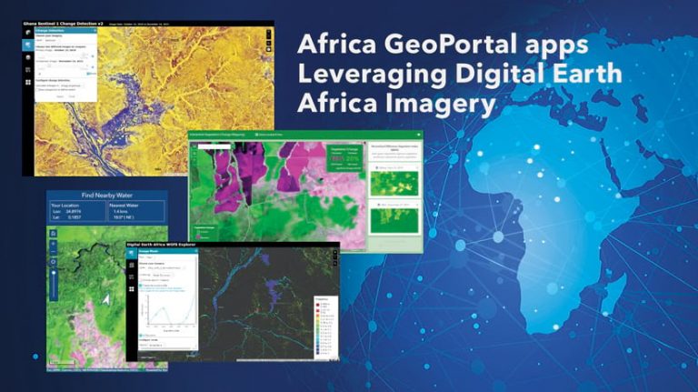
In its work with 34 GEO Community Activities, Esri is working with Geoscience Australia and others to integrate the Digital Earth Africa imagery into the Africa GeoPortal, and develop tailored applications and training materials specific to Africa. The Africa GeoPortal with Digital Earth Africa imagery is an open mapping community for data sharing, transparency, and cooperation across Africa. It enables countries to work together on investment opportunities and challenges. In the spirit of technical sustainability, Esri is committed to keeping the platform running as long as it is needed, including as a portal of portals that references and hosts geospatial data, regardless of its source.
To this end, Esri is also involved in AMERIGEO, which is a regional collaborative group for GEO members in the Americas. Esri also co-sponsors the Microsoft-GEO BON grant initiative known as Essential Biodiversity Variables on the Cloud. And finally, Esri staff are serving on several GEO Working Groups that deal with topics ranging from capacity development to climate change to disaster risk reduction.
As the danger of climate change looms, governments and their partners continue to monitor the face of the Earth. GEO will be relentless in fulfilling its credo to provide global, coordinated, comprehensive, and sustained Earth observation for better and faster decision-making that will stimulate innovation and growth, tearing down digital divides along the way. Esri is proud to be part of this effort.


