For decades, scientists have known something startling about the natural world: that biodiversity—the diversity of life on Earth—is disappearing at an unprecedented rate. Species around the globe are going extinct up to 1,000 times faster than the average rate over the last 10 million years, and the current rate is accelerating.
To better understand and monitor biodiversity changes in the United States and Canada, conservation-focused nonprofit NatureServe collaborates with a network of more than 60 programs spread across the two countries to collect data on various plant and animal species. The NatureServe Network has compiled a database with more than a million mapped occurrences of rare species and their habitats.

But delivering data from multiple providers to users across many industries presents challenges. NatureServe’s clients need access to information at a scale that informs action, yet location data that is owned by a state or other municipal entity must comply with various guidelines to protect sensitive species. For instance, if the location of a rare orchid is made widely known, someone could take it out of the wild, potentially leading to the loss of an entire population of orchids—or even that species’ extinction.
As the nerve center of the NatureServe Network, NatureServe needs to ensure that data is comparable from one jurisdiction to the next and that decision-makers can access foundational biodiversity data—all while protecting sensitive data. That’s why the organization relied on ArcGIS Enterprise to develop NatureServe Explorer Pro, a web app with interactive maps that serves as a secure, one-stop shop for clients to examine where at-risk species have been recorded and where else they might be located.
Building a Seamless, Interactive Experience
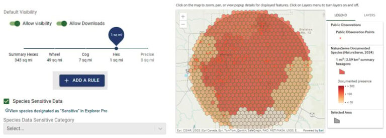
To create the database, developers first solicited feedback from members of the NatureServe Network. The members’ biggest concern was protecting sensitive species data, and each organization’s rules about data use were different. Based on members’ feedback, NatureServe created a portal that allows data providers to set permissions on how fine-scale their data is displayed. They can also obscure data for sensitive species. As a result, database users can access location data that is as precise as possible without compromising sensitive information.
Next, developers tackled the challenge of translating disparate data about tens of thousands of species into formats that could be easily displayed on a map. To do this, NatureServe leveraged KoopJS, a JavaScript toolkit that extracts geospatial data from different sources and transforms it into various geospatial outputs. With that in place, all the data that comes in from NatureServe Network members is dynamically refreshed each night, ensuring that users of Explorer Pro have the most up-to-date information.
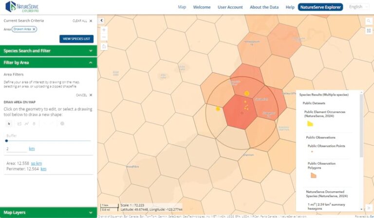
The developers then set out to create a seamless, interactive experience for users of Explorer Pro. A built-in interactive mapping tool, which relies heavily on ArcGIS Maps SDK for JavaScript, allows even non-GIS professionals to access detailed location data for species of interest. The map’s functionality ranges from simple, such as displaying a published feature layer, to complex—including drawing, buffering, and querying multiple data layers for an area of interest. The database also points users to additional resources so they can obtain more information on species directly from the data providers.

All these features deliver unique experiences that are tailored to each user’s needs. A pipeline company, for example, could upload a shapefile that outlines a potential pipeline path and create a biodiversity report for all the species that intersect with that feature. Additionally, a conservation land trust could compare possible land purchases based on a report of at-risk species on each tract of land and then select the tract that exhibits the greatest opportunities for conservation. Explorer Pro users can also gain access to curated content based on their membership in specific access groups, ensuring that they receive the most relevant and necessary information.
Filling In the Gaps with AI
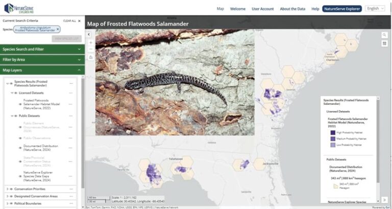
A recent development in NatureServe’s core offerings is species habitat modeling, which uses biodiversity data, environmental data layers, and AI-powered spatial computing to predict where imperiled species may be. These models fill in the gaps for areas where surveys haven’t been completed, usually due to limited time and resources.
With funding and technical expertise from Esri, NatureServe has developed more than 2,000 habitat models for at-risk species, with a focus on underrepresented groups such as freshwater invertebrates and pollinators. Esri developed a library of high-resolution predictor layers, ranging from climate to geology, that were combined with NatureServe’s precise species location data and machine learning outputs to create individual habitat models. NatureServe and Esri then worked together to aggregate these models into composite layers that guide large-scale conservation efforts.
NatureServe shares this mosaic dataset of habitat models on Explorer Pro via the ArcGIS Enterprise portal, and the composite maps are available in ArcGIS Living Atlas of the World. This enables more people to access information about the species that are most in need of protection.
Improving Sustainability in Forestry
In the forestry industry, sustainable land management and procurement practices are critical for conserving biodiversity. For decades, companies certified by the Sustainable Forestry Initiative (SFI)—which range from pulp and paper companies to providers of medical supplies—have used NatureServe’s biodiversity data to make informed decisions related to managing threatened and endangered species. That data, however, is not always available at the appropriate scale for procurement activities, especially on privately owned lands. This makes it challenging for companies to provide concise and actionable information to loggers and landowners about the species and ecological communities that need attention during harvesting.

The advanced mapping and reporting features in Explorer Pro present forestry companies with highly precise information about at-risk species and ecosystems in wood-sourcing areas. As a result, SFI-certified companies can communicate clearly and effectively with noncertified landowners about procurement practices that are best for preserving biodiversity. This not only enhances sustainable forest management practices but also contributes to the broader goal of conserving biodiversity across North America’s forests.
“At Weyerhaeuser, our commitment to sustainable forest management is paramount,” said Chad Leatherwood, senior sustainability transformation manager at Weyerhaeuser, an SFI-certified company that makes forest products. “The radius tool feature in Explorer Pro is a more recent improvement [that] allows us to more efficiently gather ecological data within a wood supply area, including species’ names and conservation status, empowering us to make informed decisions.”
How Other Industries Use Explorer Pro
Forestry isn’t the only industry that can benefit from the advanced mapping tools NatureServe created using ArcGIS Enterprise.
In the agriculture sector, pesticide companies use Explorer Pro to provide detailed endangered species proximity data to the US Environmental Protection Agency for evaluation. Agrochemical companies rely on the web app to access species habitat models and define areas where pesticide use should be limited because of threatened and endangered species.
Federal land management agencies in the United States and Canada use Explorer Pro to protect natural resources. The web app’s fine-scale species occurrence data and habitat models—customized with relevant boundary and planning map layers—facilitate conservation planning and reporting.
Conservation investors and land trusts use Explorer Pro to document and report on the impact of their investments by identifying species that are protected in key biodiversity areas and other critical sites. The web app helps them discover and manage species found in current or potential investment locations, enhancing their conservation efforts.
The development of Explorer Pro shows how advanced technology can transform the way that land managers and others approach biodiversity conservation. By addressing the complex challenges of data integration and accessibility, Explorer Pro exemplifies the innovative spirit required to tackle the biodiversity crisis.


