At Mount Diablo State Park, east of San Francisco, California, visitors can explore almost 200 miles of trails, reveling in the therapeutic sounds of crunching rock and dirt underfoot. A few years ago, hikers were often seen stopped midtrail, orienting themselves with paper maps in hand. Today, however, they can use a mobile app to see where recent rains have wiped out trails, for example, or park managers have cautioned visitors not to trek.

The Easy2Hike app, built by Esri startup partner Easy2Hike, shares up-to-date information on park conditions and potential hazards, and it’s made available offline for users in areas with low cell reception. Since the app was released in 2015, tens of thousands of hikers, bikers, and equestrians have downloaded Easy2Hike and are using it to plan park visits, enhance their hiking experiences, and learn more about their surroundings while out on the trail. In addition, park rangers use the app to share updated park information and engage with visitors.
“Park visitors want accurate park information to be able to plan and enjoy their visits, and they appreciate when it’s current,” said Uri Bar, the CEO of Easy2Hike, who cofounded the company in 2015 after getting lost on a hiking trail in Japan.
An avid hiker, Bar understood the need for an app that would show real-time hiking conditions and safe routes. He worked with Esri to develop the Easy2Hike app for California State Parks.
“By combining Easy2Hike with Esri tools, state parks can leverage their existing GIS data, maintain a single data source, and expose the most updated information in real time,” Bar said.
Getting More out of Park Visits
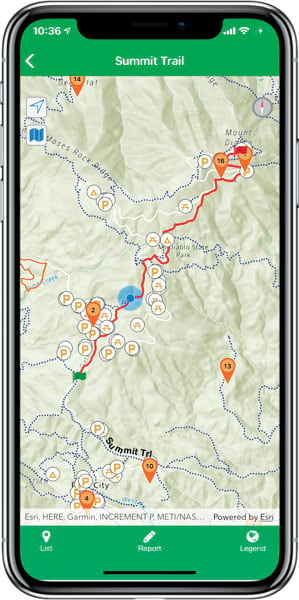
With Easy2Hike, visitors have accurate and up-to-date park information with them throughout their excursions, even if cell reception is spotty. The app can be used offline, and when reception reconnects, any reports or changes made within the app automatically get updated. The app uses location services to detect where users are and then displays nearby hikes in a list or on a map. When users select specific hikes, they can read more about them and view photos and videos related to each hike. Users can also enable push notifications within the app so they get alerts when they approach points of interest, encounter historic sites, and even veer off route.
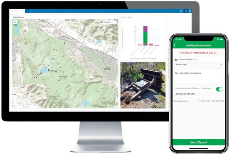
Park managers, who work to ensure that visitors know about and can locate all available trails, use the app to share and update information, such as whether certain trails are closed or there are hazards in the park. In addition, visitors can use the app to report trail obstacles, damaged facilities, and more as they explore.
The app also helps park managers track visitation stats to see where visitors go and stop to rest, as well as how long they spend on-site. Users remain anonymous, but the ability to track visitor behavior patterns helps park managers better plan where to designate resources. For example, they can use visitor tracking reports to determine where signs need to be refreshed more often or which underutilized rest stops need to be updated.

“It’s kind of a group effort type of app,” said Vincent Anibale, the public safety superintendent for California State Parks of the Bay Area District. “The more people who use it, the better it becomes. We learn from each other how to use the app better.”
Sustained Access to Updated Information
Before deploying Easy2Hike, state park managers determined that launching a mobile app could help more people safely experience nature and enjoy park offerings to the fullest. From a business standpoint, they also decided that an app would foster a personalized visitor experience, improve park management, and increase revenue to keep parks in good condition.
“A great feature of Easy2Hike is that we can send out notifications to park visitors,” said Anibale. “If there is a trail closure for some reason—like because of a mudslide from a recent rainstorm—and we had to close the trail, we can put that into the Easy2Hike map. So when visitors show up at the park, they are sent a notification, and they are able to see in real time that the trail is closed that day.”
If there is an emergency inside a park, notifications are sent to park visitors letting them know to be aware or avoid certain areas. Anibale said this enhances park security and provides a better visitor experience.
Before the Easy2Hike app, finding a park employee to get directions or more information about specific hikes was difficult for visitors, especially when out on a trail.
“Parks would have brochures with paper maps inside, but sometimes those would run out,” said Bar. “You can’t see your location on a paper map, [and] park rangers can’t print or indicate trail closures on these brochures. It just didn’t give a great or detailed look at the park like we now can do with the app.”
With Easy2Hike, if visitors need information, they can just pull the app up on their phones and be up-to-date with what’s happening inside the park they’re visiting.
“This app puts downloadable maps, information, and routes in the palm of their hands,” Anibale said. “It’s easy to access, and it keeps updated information right on hand.”
Collaboration Improves Experiences and Data Accuracy
Easy2Hike uses ArcGIS Enterprise to maintain its extensive GIS database of park trails and facilities. The GIS team for California State Parks publishes feature services in ArcGIS Online to make the data—which includes the locations of trails, restrooms, parking lots, and picnic tables—available. The Easy2Hike native mobile app, built with ArcGIS Runtime SDKs, consumes these feature services.
“The app displays layers on a map, showing park trails and facilities and allowing visitors to easily navigate all over the park,” said Bar. “The offline map is also implemented using the SDK.”
At the same time, the California State Parks GIS team uses visitor input to improve data accuracy and update its GIS database. As Easy2Hike users report missing facilities and incorrectly marked trails via the app, information is delivered to the GIS team via the Easy2Hike park portal. The GIS team then runs further analysis on visitors’ suggestions and incorporates the necessary changes into the GIS database.
Continued collaboration between park managers, visitors, the GIS team, and Easy2Hike results in an even better experience for visitors. This means hikers, bikers, and equestrians can now focus on the sights and sounds of their park visits instead of spending too much time searching paper maps.
“We are creating a new standard for hiking,” Bar said. “Park visitors will get the same high-quality and great experience in each park we operate in.”

