Planning and siting new linear infrastructure—such as power lines, roads, railroad tracks, and pipelines—is a complex process. Searching for suitable routes and optimal locations for new projects can be challenging, requiring relevant technical, regulatory, and environmental knowledge as well as coordination among many stakeholders.

Arcadis Germany, a globally recognized engineering company with a focus on innovation and sustainability, is seeking to revolutionize the way linear infrastructure projects are planned, designed, and executed. The company’s digital solutions team is leading the digital transformation of environmental project planning by providing expertise in GIS and spatial data management to projects that range from updating railways and transportation systems to modernizing power grid networks.
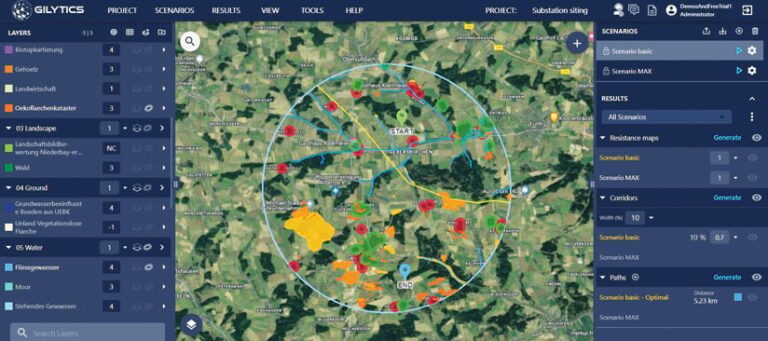
To address the needs of engineering companies like Arcadis Germany, Esri startup partner Gilytics has developed Pathfinder, a multiuser, cloud-based decision-making platform that is rooted in GIS. Pathfinder optimizes infrastructure design, planning, and routing—and emphasizes sustainable grid development—with awareness of multiple spatial and nonspatial parameters. This increases stakeholder engagement and, ultimately, transparency.
Simplifying a Long Process
Conducting effective infrastructure planning requires staff at Arcadis Germany to collect and review all the relevant data that informs planners of a project’s area restrictions.

Before implementing Pathfinder, the digital solutions team at Arcadis Germany used GIS to manually review planning rules to ensure that people and environments are protected. This entails verifying that infrastructure is built at safe distances from urban areas and residential buildings and that environmentally sensitive areas are preserved. Additionally, to assess the suitability of a particular plot of land or route, planners must consider technical and cost constraints.
Thus, spatial planning for infrastructure projects is a long process that requires multiple revisions based on feedback from a variety of stakeholders. Evaluating and comparing project results and visualizing alternatives requires advanced GIS capabilities and tools that, in the end, simplify the assessment process.
Arcadis Germany was given the opportunity to test and use Pathfinder during one of its large-scale transmission line projects in Germany. The digital solutions team was impressed.
“The software is intuitive and offers great advantages in corridor identification and routing, especially if you work with multiple [types of] geodata,” said Frank Dünkel, head of digital solutions at Arcadis Germany.
Combining Routing and Siting Algorithms with Advanced GIS
Pathfinder is available as an ArcGIS Pro add-in. This enables GIS users like Arcadis Germany’s digital solutions team to employ Pathfinder’s routing and siting optimization algorithms while using ArcGIS Pro and its advanced analytical capabilities. This means team members don’t have to spend time building large or complex models.

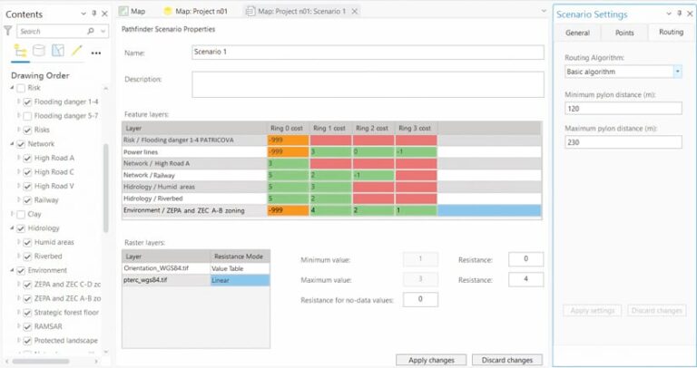
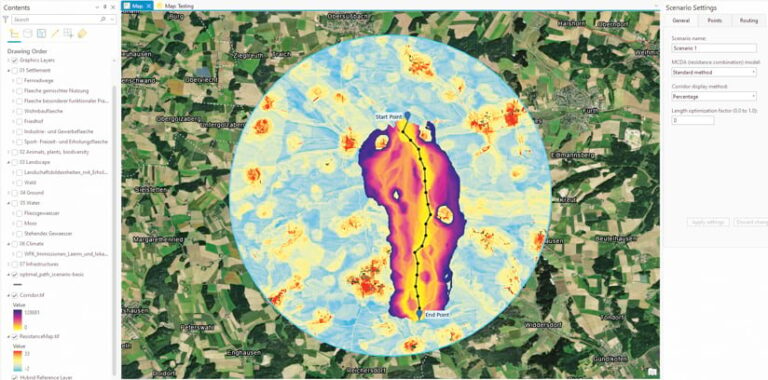
The add-in allows users to easily create and test project scenarios. For Arcadis Germany, for example, this allowed team members to plan the connection of large offshore wind farms in northern Germany with the country’s industrial centers in the south. The team used ArcGIS Pro’s data management tools to import and prepare GIS data for the project. Once the data was ready, the team accessed the Pathfinder add-in’s scenario planning capabilities. Team members were able to use buffers to incorporate project requirements, like ensuring that specific environmental areas and social elements are protected. Team members also assigned suitability costs to each area to either allow proposed routes to cross sensitive areas or block them from doing so. And customized multicriteria decision analysis and routing algorithms allowed the team to adjust planning rules and minimize costs.
Being able to automate the planning process and generate results using the Pathfinder add-in enables those involved in a project to make target-oriented decisions. In addition, projects are automatically copied in Pathfinder’s cloud environment, which makes it easy to visualize the results in both 2D and 3D and communicate interactively with stakeholders.
“Gilytics’ Pathfinder definitely speeds up planning processes [by] several weeks [and] up to months, depending on the existing know-how and the project requirements,” said Dünkel. “In particular, for users who do not program themselves, the software represents an enormous benefit, as the no-code environment is easy to handle. So Gilytics’ Pathfinder provides almost every team member with a possibility to calculate corridors as an estimate for optimal routing in planning phases. Results can be visualized, documented, and easily exported. This way, team capacities can be distributed much more flexibly, and a lot of time can be saved.”
Fostering a Participatory Feedback Loop
By helping users collect and share feedback and quickly create interactive alternative designs, Pathfinder is enabling companies like Arcadis Germany to streamline the infrastructure design process, improve project visualization with 3D imagery, and increase transparency. What’s more, the integration of Pathfinder with ArcGIS Pro allows planners and engineers who are experts in different fields—from environmental analysis and technical constraints to cost assessments—to run their simulations, share them with colleagues and other stakeholders, and develop a more participatory feedback loop.
Pathfinder can be downloaded from ArcGIS Marketplace. For inquiries about trial opportunities, licensing options, and other ways that Gilytics can empower engineering and planning teams, email Elena Rodriguez Tormo, client relationship and project manager at Gilytics, at elena.rodriguez@gilytics.com. For more information about Arcadis Germany, email Frank Dünkel, the company’s head of digital solutions, at frank.duenkel@arcadis.com.

