Accessible sidewalks are essential for inclusive and livable communities. They ensure urban mobility; improve overall safety; and foster a healthier, more vibrant environment—especially for people with mobility issues. Yet many cities have sidewalks that are uneven, poorly maintained, or absent altogether.
To address this critical issue, the Americans with Disabilities Act (ADA), passed in 1990, requires that every public entity with 50 or more employees maintain an ADA transition plan. The plan details how a given organization will remove physical barriers to accessibility in their facilities and services. When the ADA transition plan is applied to sidewalks, ensuring accessibility is a necessary yet intricate task. It requires evaluating hundreds of miles of sidewalk spaces.

When the Town of Erie, Colorado, began preparing to address sidewalk accessibility as part of its mission to empower more than 33,000 residents through community access and inclusion, staff began working with the WT Group—an engineering, design, and consulting firm—to develop a robust transition plan. To streamline and simplify sidewalk evaluations in Erie, the accessibility team at the WT Group turned to Esri Startup partner DeepWalk for help incorporating geospatial technology.
Paving the Way for More Accessible Cities
Headquartered in Chicago, Illinois, DeepWalk Research, Inc., was founded in 2018 by Anshul Shah and Brandon Yates to provide sidewalk inspection solutions that help public entities improve accessibility. DeepWalk’s automated inspection software uses lidar scanners on iPhones to assess the accessibility of sidewalk systems, providing municipalities, universities, and other organizations with data for the creation, implementation, and maintenance of ADA transition plans.
With more than 250 sidewalk miles, Erie needed an automated and scalable solution that could scan sidewalks and determine whether or not they met accessibility standards. DeepWalk’s ArcGIS technology-integrated software provided the tools and mapping solutions required.
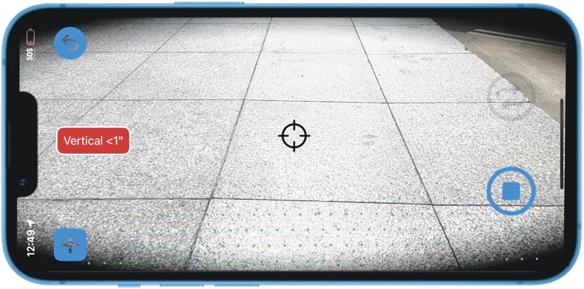
In the past, data collectors inspected every individual sidewalk panel with a tape measure and a level—a demanding and time-consuming process for municipalities with hundreds of sidewalk miles. With DeepWalk’s iPhone-based lidar scanning app, data collectors scan sidewalks as they walk them. These scans generate photorealistic 3D models of the sidewalks that are then processed with DeepWalk’s automated measurement system and delivered on its web app.
For Erie’s self-evaluation, a team of three data collectors from the WT Group gathered 56.5 miles of Erie’s sidewalk and curb ramp data in only five days. Once uploaded from their mobile phones, Erie and the WT Group continuously received the data as it was processed and could easily track the progression of the project in DeepWalk’s web app.
“We were very happy with the efficiency of the DeepWalk tool,” said Tatum Storey, accessibility practice principal for operations at the WT Group. “Every municipality we work with uses GIS, so this system could be replicated in every city across the country with a public sidewalk system.”
For customers like Erie, DeepWalk automatically measures and identifies access barriers within the sidewalk network. Checking for measurements like sidewalk panel widths, slopes, and detectable warning surfaces, the data extracted from the scans provides essential information for the development of ADA transition plans and other sidewalk improvement programs.
-
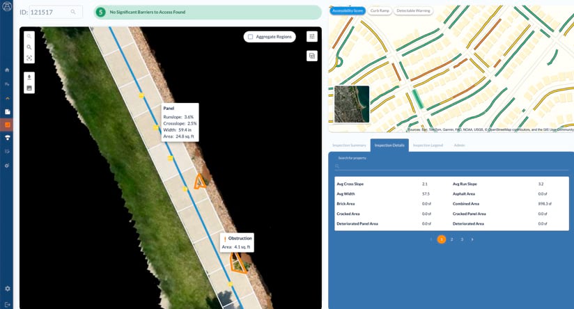
DeepWalk users upload sidewalk scans and receive processed data on the web app, where they can view inspection results and integrate with ArcGIS.
To meet the specific needs of these projects, DeepWalk users have a customizable experience in which tags are created for specific data points to track within their sidewalk network. For Erie, manual tags were set by the WT Group to collect location information about trip hazards and driveways within the sidewalk network. Once processed, the data point type is extracted into its individual mapping layer to be integrated into ArcGIS Online.
Integrating DeepWalk and ArcGIS
ArcGIS Online enables DeepWalk users to complete advanced analyses of their sidewalk data. In just a couple of clicks, DeepWalk’s ArcGIS integration delivers preformatted mapping layers with 58 precomputed fields. The time spent on styling and formatting these layers gets reduced by up to 15 hours, allowing GIS teams to allocate more resources to creating project-specific customizations, advanced mapping solutions, and informative dashboards that aid the development and maintenance of their transition plans. In addition, being able to visualize this data in ArcGIS helps communicate accessibility needs clearly to stakeholders.
In minutes, Erie’s processed data seamlessly integrated into ArcGIS Online, featuring layers for sidewalk and curb ramp access grades, the tags for trip hazards and driveways, and measurements. Using DeepWalk’s sidewalk grading algorithm, access grades are assigned to each scan on a zero-to-five scale. Sidewalks with severe barriers to accessibility are considered noncompliant. They are assigned a score of zero and represented in red on the map. Compliant sidewalks with no discernible barriers to accessibility are assigned a score of five and represented in green on the map. The combination of data visualization in ArcGIS and DeepWalk’s scoring system is significant for sidewalk improvement efforts because it is easy to identify priority areas across a region.
Beyond ranking based on access barrier type, Erie’s sidewalk layers can be combined with existing datasets to prioritize areas that are within proximity to important public facilities, that experience high levels of foot traffic, or that are densely populated. Advanced mapping analysis in ArcGIS transforms sidewalk and curb-ramp data into actionable insight, and facilitates the creation of sidewalk improvement programs such as eliminating trip hazards or removing vegetation.
As Erie continues to develop its ADA transition plan, DeepWalk’s manageable mapping solution—which outputs downloadable files for planning programs in the region—makes it easier to prioritize and implement remediation efforts. Additionally, as Erie completes various sidewalk enhancement programs, the town’s data can be updated in ArcGIS to reflect the improved conditions. This allows Erie to keep its ADA transition plan current and ensures that all improvements meet compliance standards and are recorded and represented accurately.
About the author