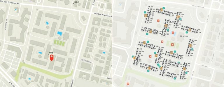
Accurate addressing is crucial to the rhythms of modern life. Whether dispatching basic deliveries, ensuring that service providers perform the right work, or helping emergency responders save lives, there are times when it’s critical that people be found.
But in an age when communities and industrial areas are continually changing or expanding, accurate addressing, in some ways, has never been more complicated to achieve. It can be difficult to locate the right address, especially in large multiunit developments such as apartment buildings, colleges, hospitals, and commercial complexes. And the time wasted trying to complete the last 100 feet of an address search can be costly.
That’s why one innovative company, Esri startup partner One Hundred Feet, is using advanced geographic data to improve address accuracy at every step of the journey.
The Challenges of Complex-Level Address Data
In the United States, about a quarter of all recorded addresses contain multiple units. Those units sometimes have distinct spatial locations, making them hard for people to find once they arrive on-site.
With most complex-level address data, one location point represents many individual units that are spread over a considerable area—at times even in separate buildings. What’s more, depending on what the adjacent road network looks like, some units aren’t even accessible from the official address point.
This lack of accurate subaddress geocoding creates significant challenges. Delivery companies, for example, experience costly delays in the final 100 feet of distribution if their drivers have to search for the correct address. This kind of time wasted is particularly challenging for gig-economy delivery drivers, who depend on efficiency to ensure customer satisfaction and, ultimately, their ability to earn an income.
Inaccurate unit-level addressing also affects utility and internet companies that are looking to provide precise services. And when emergency responders need to reach people quickly, they can’t afford to spend time searching large complexes for the correct unit.

Precise Location Data to Navigate Multiunit Developments
One Hundred Feet, a geospatial mapping company based in Palo Alto, California, is using precise location intelligence to create maps of addresses in complexes that include even structural features such as stairwells and entrances. The data that the company generates enables users to navigate to an exact destination in a housing, office, or industrial complex, eliminating the problems that tend to occur in the last 100 feet of an address search.
The startup built an adaptable framework that integrates address data drawn from diverse sources, including field operations and machine learning data models. Its in-house tools, combined with GIS software made accessible through the Esri Startup Program, have allowed One Hundred Feet to move quickly to create detailed address data for complexes across the United States.
“Becoming an Esri startup partner gave us access to a wide range of remarkable GIS tools and solutions,” said Nitin Gupta, cofounder and CEO of One Hundred Feet. “It’s really helping us tackle the toughest challenges in address mapping.”
Employing massive field operations using apps such as ArcGIS Survey123 and ArcGIS Collector, together with machine learning models, One Hundred Feet is creating a wealth of data for apartments and multiunit dwellings at scale. Its data includes the following:
- Unit geocodes—accurate locations of units in apartment buildings and other types of complexes
- Semantic waypoints, such as the locations of entrances, elevators, and parking, to enrich unit context
- Points of interest, including swimming pools and community entrances
- Above ground level (AGL) and above sea level (ASL) elevation
By combining location and elevation data, One Hundred Feet’s datasets can be used in augmented and virtual reality simulations of apartment units and other features. Additionally, the company is working on accurately mapping indoor elements to enhance indoor navigation.
To accommodate the wide array of use cases for this subaddress-level data, One Hundred Feet provides its data in several formats, including a hosted geocoding service, hosted feature services (for units, entrances, points of interest, and more), reference tables, and an enterprise geodatabase. This range of offerings allows users to easily integrate the company’s services into web apps, mobile apps, ArcGIS Pro, ArcGIS Online, and more.
A Positive Impact on Several Industries
One Hundred Feet has mapped more than eight million apartment units in the United States and now has what it believes to be the largest database of pinpoint multidwelling address locations in the country. With its unit locations presented as point features, the company has generated a granular network dataset of high-quality subaddress data that is already having an impact on several industries.
Delivery drivers, for instance, have reported reduced trip times of, on average, two to eight minutes per trip and a 40–50 percent decrease in failed deliveries. Both outcomes have a direct impact on logistics companies’ bottom line.
Utility asset managers can now perform network tracing and modeling at the subaddress level. This helps them provide more accurate and timely services.
And public safety agencies that use One Hundred Feet’s subaddress unit location data, along with maps that show key features such as entrances, parking locations, and stairwells, have reported reduced arrival times for emergency responders. According to the American Heart Association, when someone has a cardiac incident, every minute that passes without CPR decreases that person’s chance of survival by 7–10 percent. So the faster that emergency responders can find people, the greater the number of lives that can be saved.

