The residents of any city rely on dependable performance from utilities to keep their lives on track. But when construction or new asset installation damages underground utilities such as gas, water, or power lines, the consequences can be disruptive and expensive—even deadly.
A utility strike occurs when a crew accidentally encounters and damages underground utility pipes or wires during excavation. In the United States, a utility strike occurs every 60 seconds on average. By some estimates, inaccurate location information about underground infrastructure causes a $50 billion to $100 billion cost to the US economy every year. These costs include project delays due to redesigns and approvals, overtime for utility employees, and insurance premium increases for large contractors and asset owners.

In December 2022, when Greater Wellington, New Zealand, initiated the Te Wai Takamori o Te Awa Kairangi (RiverLink) project to perform vital flood protection improvements, transportation upgrades, and urban revitalization efforts for the area of Te Awa Kairangi ki Tai (Lower Hutt), planners knew they needed to avoid utility strikes. They turned to Esri startup partner Reveal for help.
Understanding What’s Underground
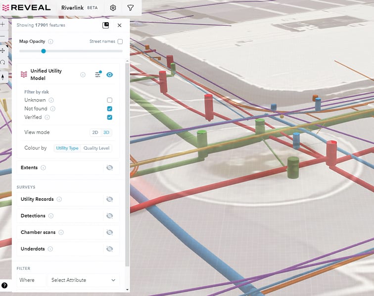
Reveal, a New Zealand-based utility locating technology company, is breaking new ground in the visualization of underground utility risks. The company uses ArcGIS Online, ArcGIS Pro, and ArcGIS Maps SDK for JavaScript to power what it says is one of the largest and most accurate subsurface utility models ever created.
Reveal started as a traditional “boots-on-the-ground” utility locating service business, but CEO and founder Sam Wiffen was eager to build a foundation of technology and innovation in an industry where modernization has not come easily. “If we could ensure that contractors and project owners could accurately and easily implement subsurface data, we could reap huge efficiency gains at every stage of the project life cycle, from [the] concept and design phase through to construction,” Wiffen said.
The Te Wai Takamori o Te Awa Kairangi project team engaged Reveal to complete a comprehensive utility model that could be used to plan further investigations and inform partners on the status of the underground utilities within the planned project footprint.
Combining Field Expertise with Groundbreaking Technology
The most accessible information on underground utilities has been historical utility plans, often provided by asset owners on request to contractors who need to do swift construction or make immediate repairs. The plans were often only available via paper or PDFs—or by simply making physical markups on the ground. The downside of this information is that it is often inaccurate or incomplete, leading to the risk of utility strikes and project delays.
In response, the field of utility locating has emerged to provide more accurate location and survey data, but the output from these manual geophysical investigations is expensive to procure and requires high levels of expertise to interpret. Worse still, these valuable deliverables are sometimes shelved by the asset owner or lost on completion of a project.
What has been needed is a holistic approach, one that combines existing utility plans with modern survey methods and applies a layer of verification and authentication to the location data. Also needed is an intuitive, cloud-based platform to visualize and share the results.
Accurate Mapping of Unseen Utility Equipment
Mapping underground assets poses an unusual challenge for mapping software—the objects being mapped are often concealed or detected using probabilistic techniques rather than direct observation. The temporal data (when an object was detected) and chain of evidence (what techniques were used and how accurate they were) are also unfamiliar metadata layers that need to be displayed intuitively to users interested in the subsurface. Finally, mapping the depth element is especially critical for water utilities, which necessitates mapping objects in three dimensions relative to an ever-changing surface elevation.
Underground utilities are composed of a large number of types, components, shapes, and other metadata, from utility access holes and chamber lids to telecommunications cables, grates, sumps, and more. Distinct symbology and color codes for utility types are understood throughout the industry, and any technology platform needs to be able to accommodate different styling and displaying of these objects in three dimensions while maintaining smooth performance for large project areas.
“One of the most significant benefits of using the Reveal model is its potential to reduce the need for invasive investigations,” said Samantha Smith, utilities project manager for the Te Wai Takamori o Te Awa Kairangi project. “By highlighting unknowns and higher-risk areas, the model allows for targeted investigations and utility relocations planning. This approach minimizes disruptions and costs associated with more invasive methods.”
Reveal chose to build its platform in ArcGIS Online for its ease of use and wide industry acceptance. “[JavaScript Maps SDK] and ArcGIS Online allow developers to deliver the most complete range of data types via the browser, with a reasonably low amount of custom code creation,” said Reveal CTO Tim Rastal.
Reliable Insight and Versatility
The work at Te Awa Kairangi ki Tai was completed in two stages, with the first stage involving a comprehensive 2D desktop study. Reveal’s team compiled information from various sources, including utility providers, to make sure the data was up-to-date. This initial step ensured that the foundation of the model was built on accurate and reliable information.
Following the desktop study, Reveal performed a ground-penetrating radar survey. The survey data was processed and used to update the model from 2D to 3D, providing an even more comprehensive understanding of the subsurface infrastructure by adding crucial depth measurements to the model.
“One of the standout features of Reveal’s model is its versatility,” said Smith. “The model can be exported in various formats, making it compatible with our design software. This compatibility enabled seamless integration of the model into our planning and design processes, making it an invaluable tool. The visual presentation of the model is impressive, and the user interface is intuitive and easy to navigate.”
The Reveal team took only three months from project inception to delivery of a full-fledged unified utility model in a web-based platform for RiverLink’s designers and engineers.
“Reveal has proven to be innovative and forward-thinking in their field of subsurface utility investigations,” said Smith. “Their diligent and thorough approach, coupled with the creation of a visually appealing and user-friendly model, has enabled us to plan further investigations and inform our relocations design with confidence.”

