Tracking the Consequences of the Guatemalan Eruption

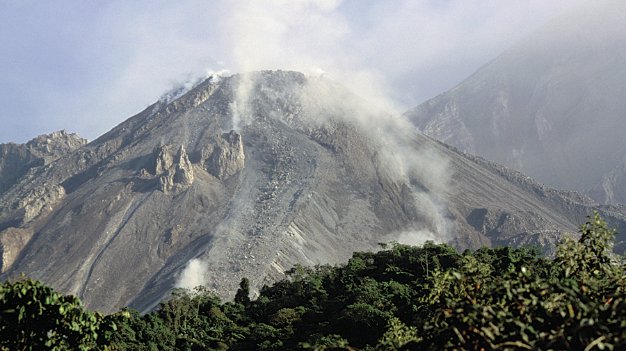
On the afternoon of November 28, 2012, the Guatemalan volcano Santiaguito erupted, launching sand and ash three kilometers into the air. Lava and gas spewed into the surrounding area—some in areas as far as 80 kilometers away. This eruption was considered by the authorities to be a “very strong” one, and the National Meteorology Agency recommended restricting air traffic in the area. Nevertheless, according to the National Coordinating Commission for Disaster Reduction (CONRED), there was no immediate need for evacuation of populations closest to the mountain.
Santiaguito is located in a popular tourist area about 220 kilometers from Guatemala City in the Department of Quetzaltenango. Known as the western highlands of Guatemala, the area sits 2,550 meters above sea level. The volcano is located only 11 kilometers from the city of Quetzaltenango. People in the Quetzaltenango area were already experiencing hardships from an earthquake that shook the region three weeks earlier, killing nearly 50 people and leaving 25,000 homeless.
GeoCensos, a nongovernmental organization comprising international and Latin American experts and researchers, was invited by Washington, DC-based humanitarian organization iMMap to join coordinated efforts in the area to identify damage and emergency response for the Guatemalan government and report them to CONRED. GeoCensos explores topics related to geospatial technology, such as data mining and digital mapping applications, applying recent census results. A large part of the organization’s core activity is to produce information updates based on censuses and geographic information trends happening in Spanish-speaking countries. In the case of the volcanic eruption, GeoCensos was looking for applications that could streamline the provision of real-time georeferenced data, such as social networks, to understand what was happening during the event.
Finding the Right Fire Hose to Make Sense of Emergency Data
Staff at GeoCensos decided they needed an easily accessible tool to describe at a glance what was going on live in the affected region. Social media is well on its way to becoming a valued source to understand emergencies, but many times, there is a lot of data being posted quickly. Trying to channel the flow of this “fire hose” of information is the key to applying it. Researchers at GeoCensos were looking for a tool that could help them make sense of all the available near real-time data being posted when the volcano erupted. They understood that the coordinated emergency efforts of all the first responders could benefit from using these tools. The one they chose was the social media widget for Flex developed by Esri and available online at ArcGIS.com.

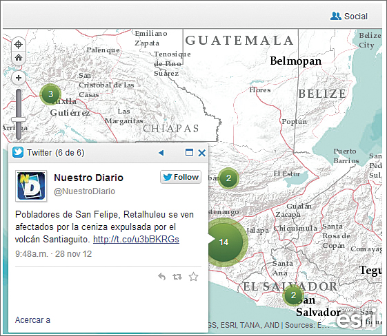
This application was chosen because it helps the user create thematic layers to display information from a variety of social media sources: Tweets from Twitter, images from Flickr, and YouTube videos, along with other data about events happening in the disaster area, such as United States Geological Survey earthquake ShakeMaps and real-time local weather reports. Terrain basemaps readily available on ArcGIS Online were used as the base layer to display the social media information. Using the social media widget and data available from ArcGIS Online, GeoCensos was able to tap into a worldwide community of mapped data and create a readily accessible alert tool.
Emergency networks like CONRED, which was created to prevent disasters or reduce their impact by coordinating relief efforts, also provided data. CONRED is responsible for assessing potential hazards, as well as impending or actual disaster, by reviewing data from the Executive Secretary of CONRED and the National Institute of Seismology, Volcanology, Meteorology, and Hydrology. Once a disaster has been declared, such as the eruption of the volcano, CONRED is responsible for declaring states of alert and coordinating disaster relief efforts.
Assessing the Eruption Through Social Media
Using only the Internet, GeoCensos staff screened live messages and pictures posted by people affected by the volcano through the social media widget. The widget streamed this social media into the appropriate application, including the Common Operational Picture template, also created and provided free by Esri. GeoCensos configured the application to collect georeferenced information from three different social networks in the area of interest with selected thematic restrictions. The restrictions they used were mainly messages that were preconfigured to display from authoritative agencies—such as where to go for assistance—or those related to key search words and the hashtags #santiaguito, #erupción, and #afectados on Twitter.
CONRED closely monitored not only recent seismic activity but also the activity of the volcano and provided this data as updates throughout the event. GeoCensos shared the social media map with CONRED as an informal supplement to incoming earthquake and eruption information for the emergency response activities of the organization. CONRED did not consider it merely a demonstration exercise; the map was used to justify decisions.
Tools like Esri’s social media widget can be particularly effective if the general emergency system in a given country aims to alert the public and reduce the impact of disasters. During a time when many budgets are shrinking, involving the community to generate geospatial data can be very helpful. GeoCensos found that introducing these new nodes of emergency information—information from social media—together with census data, especially housing, can save time and effort at moments of crucial importance.
About the Author
Javier A. Carranza Tresoldi is chief editor, GeoCensos, and has an MSc in geoinformation from Twente University.
For more information, contact Javier A. Carranza Tresoldi, GeoCensos.

