Naftna Industrija Srbije (NIS) is the biggest petroleum company in the Republic of Serbia and also the country’s largest company. Founded in 1949 as the Oil Exploration and Production Company, NIS has expanded its operations to include exploration, refining, sales, and distribution. It is a multinational company with subsidiaries and offices in Bosnia and Herzegovina, Bulgaria, Hungary, Romania, Russia, Croatia, and Angola.
Until 2009, NIS and its assets were owned by the state. That year, the Serbian government decided to sell off a portion of the business. The new majority shareholder in NIS reorganized the company in its entirety, and part of that restructuring included establishing a new division of NIS called the Department of Real Property Management. The primary purpose of this new department was to reregister ownership rights for all pieces of NIS property that had previously been registered under the state, as well as record all formerly unregistered assets in the Serbian Real Estate Cadastre (REC).
“When ownership changed, it became essential that a process be implemented to formally map and register rights on the fixed assets owned by NIS so they could be formally registered in Serbia’s Real Estate Cadastre,” said Marko Maric, the GIS manager and director of land affairs in the Department of Real Property Management. “To successfully complete this task, it was necessary to have an accurate inventory of all our properties.”
For this reason, NIS implemented ArcGIS Enterprise in 2011.
“Normally, a petroleum company implements a GIS to help field operations and to maintain its facilities or manage its pipeline infrastructure,” Maric pointed out. “However, in our case, we did it for the purpose of property rights registration.”
From Simple Web App to Key Technology
According to Maric, the original idea for using GIS at NIS was to create an app that would help the company register assets in the official state registry—the REC—and then expand its use from there. In 2011, NIS began developing an enterprise web app called GIS ODEON (which, in Serbian, stands for Unified Digital Registry of Immovable Assets).
“Our initial release was later that year, and it was just a small web app that was used for visualizing our assets on a map,” said Maric. “At that time, there were about 25 users of the application, and they were all in the Department of Real Property Management. Since then, we have recorded the exact positions of more than 25,000 fixed assets, including land parcels, buildings, production facilities, wells, pipelines, utilities, tanks, office space, and apartments, which are mapped through the geodatabase.”
Over the last eight years, the staff at NIS have increasingly understood the value of integrating and analyzing georeferenced data and making it part of the decision-making process. This is also supported by management and is now an important part of the company’s operations.
“I refer to this as the GISification of NIS,” said Maric. “By applying GIS functionalities and using different kinds of data from geodatabases, many business processes have become easier and more efficient. Finding spatially related data in our existing workflows has spurred the further development of this enterprise app, making it very useful for a wide variety of applications throughout the company.”
Although the Department of Real Property Management has continued to use GIS ODEON in more advanced ways, the largest number of active users today is from the upstream (exploration and production) and downstream (refining, marketing, and distributing) divisions. That said, there are also quite a few app users from capital construction, accounting, investments, health, safety and environment, and corporate security. Additionally, Maric and his team have adapted the app so that employees in NIS-affiliated companies in Bosnia and Herzegovina, Bulgaria, and Romania can use it for asset management as well.
A Complete Picture of Assets
GIS ODEON manages three different types of data, including a geodatabase, a relational database, and another database that is specifically for scanned documents and attachments. This allows NIS to limit access to the data to different user groups, depending on their needs and potential uses for the data.
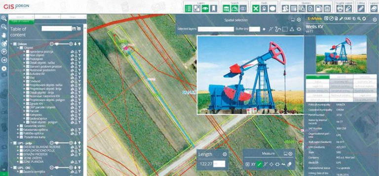
“The ability of this application to integrate georeferenced assets with a variety of other data and documents related to that asset—such as legal, cadastral, accounting, lease, land surveying, and so on—is invaluable to our entire operation,” said Maric.
NIS can also include photos and scanned documents, such as building permits, usage permits, title deeds, and contracts, in the database. Thus, the company has a complete picture of all its assets that is easily accessible from the central database maintained by GIS ODEON. This makes the app valuable to departments throughout the company.
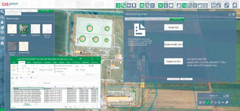
“For example, by having all company assets specified on a map and linked to supplemental data, employees in the field can easily do audits to maximize the effective use of company real estate using the mobile app GIS ODEON Survey, which we developed,” said Maric. “By determining the coordinates of an asset, they can measure the distance between them and other areas of interest for the potential acquisition of additional assets or the sale of current ones. With the implementation of the Query Builder tool (a four-step module for non-SQL experts), users are now able to easily get a wide variety of reports from both the geodatabase and the [relational] database based on their specified criteria.”
GIS ODEON has other specialized outputs as well. The Passport of Assets, for instance, is a PDF that helps NIS monitor specific assets from a legal perspective. Additionally, the app can be used to create more accurate and detailed work orders for appraisers.
“We have also implemented thematic views in GIS ODEON so that users can easily understand the current status of an asset,” said Maric. “The views can specify, by color, property registration rights or exploitation status, or even the current status of the implementation of corrective measures necessary for some assets.”
Future Plans for the App
Because of the myriad uses of GIS ODEON, the number of users at NIS continues to grow. Currently, the app has more than 370 active users.
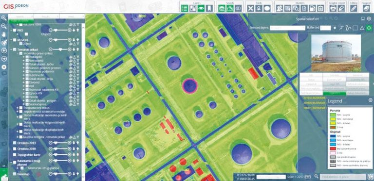
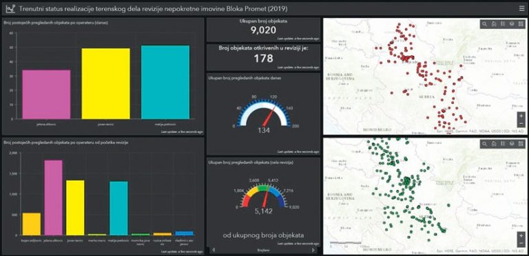
“In addition, we are getting regular requests for the implementation of new functionalities in the app that will help employees fulfill their specific business needs,” said Maric. “Through the dashboard available on the GIS ODEON portal, our management can get a clear view—in real time—of the current status of audit projects.”
Future planned functionalities for GIS ODEON include a pipeline maintenance module that will be part of the existing app, the ability to support more precise property tax filing procedures, and a separate app for fleet management.
“We also have a plan to synchronize data between ArcGIS and IBM Maximo to enhance the system’s asset management capabilities and integrate our supervisory control and data acquisition (SCADA) system with our geodatabase,” added Maric. “In addition, we are discussing future implementation of an ArcGIS Indoors application that would be very useful for building maintenance and in the event of an emergency.”

