The state of São Paulo produces nearly one-third of Brazil’s gross domestic product (GDP), according to the Brazilian Institute of Geography and Statistics. Its capital city, also São Paulo, is considered an alpha city by the Globalization and World Cities Research Network, meaning it links important economic regions to the rest of the world. Key industries in the state include aerospace and defense, agribusiness, automotive production, oil and natural gas, health care, financial services, and communications.
To sustain economic growth, the state’s Department of Development created a division called the Investment Promotion Agency for the State of São Paulo (InvestSP) in 2008. The focus of InvestSP is to act as a gateway for new investors and support companies that are already established in the state.

One of InvestSP’s primary roles is to help investors and entrepreneurs select sites for their new or expanding businesses. While the government organization started out employing a manual, statistics-based method for this, leaders at InvestSP quickly realized that they needed to employ GIS to a greater degree to spatially inform their decision-making. That’s where ArcGIS Pro and several powerful extensions now come into play.
A Statistical Process Has Limits
Location intelligence is central to InvestSP’s three primary services, according to Pedro Fittipaldi, investment manager for the environment at InvestSP.
“First, we help entrepreneurs identify the best locations in the state to invest, according to the needs of their activity, including workforce, infrastructure, incentives, logistics, availability of suppliers, size of consumer market, and the environment, among other factors,” he explained. “Second, we assist potential investors in their dialogue with public agencies, with the intent to facilitate the decision-making process and the implementation of new projects. Lastly, we provide specific and strategic information on the best locations to invest, depending on our investor’s requirements, in the state of São Paulo.”
Initially, teams at InvestSP used a statistics-based process to conduct site selection for new businesses in São Paulo. They would take economic data and cross-reference it with generic sector needs to help identify suitable municipalities for each project. After investors agreed on a short list of locations, InvestSP employees would contact each municipality with a list of potential sites for the project to work out more details and whittle the list down to a final location.
This process was effective for many situations. But after a while, its shortcomings became clear—especially when it came to considering site characteristics that don’t necessarily follow municipal boundaries, such as zoning, surrounding infrastructure, available natural resources, and environmental restrictions. So in 2012, InvestSP began working with Imagem, Esri’s distributor in Brazil, to develop an ArcGIS Desktop software-based spatial intelligence system for site selection.
“Imagem has always provided us with valuable updates, insights, and help in the development and implementation of GIS solutions,” said Fittipaldi.
ArcGIS Technology-Based System Improves Site Selection
ArcGIS Pro is now the foundation of InvestSP’s system, which also makes heavy use of ArcGIS Data Interoperability, ArcGIS Spatial Analyst, and ArcGIS Business Analyst Desktop. The data maintained in the system, which includes hundreds of demographic and economic characteristics at the municipal, regional, and state levels, is regularly updated by business intelligence specialists. This allows the investment projects team to create dozens of political, economic, and environmental maps.
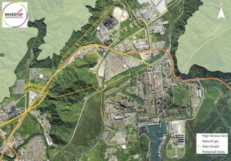
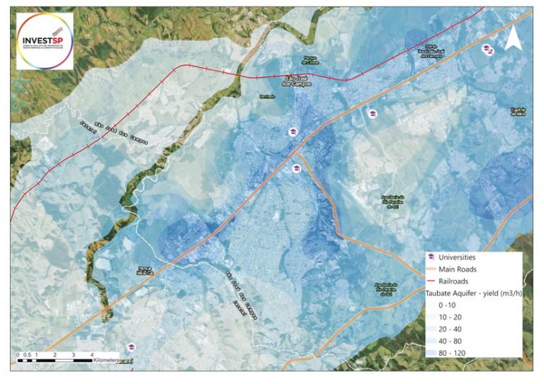
For site selection, ArcGIS Pro is used to “filter municipalities and locations according to project criteria to produce cartographic materials, which are used in the presentations we send to investors and other decision-makers,” Fittipaldi explained. “It is also extensively used in our environment and infrastructure consultancy processes, which encompass evaluations such as energy connections, environmental restrictions, and so on.”
The typical site selection process for a project now starts by forming a list of potential locations based on parameters that the investors set. InvestSP has a database of more than 1,000 sites that are suitable for development throughout the state of São Paulo. The business intelligence team takes this, together with additional criteria provided by the investors, and cross-references it using ArcGIS Pro to pare down the initial long list of potential sites into a final list of up to five sites that are appropriate for that specific development. The investors then evaluate these sites in greater detail until they reach a decision.
Spatial Analyst has been particularly useful for producing customized multidimensional cartographic products that the business intelligence team at InvestSP can use to display a single layer.

“For instance, InvestSP was recently requested to support a strategic regional telecom infrastructure investment initiative in one of São Paulo’s least-developed municipalities as part of [the state’s] Vale do Futuro (Valley of the Future) Program,” said Fittipaldi. “We did this by creating a weighted overlay map to highlight areas which should be prioritized considering population, schools, medical clinics, tourist attractions, presence of traditional peoples, and other characteristics.”
Fittipaldi and his team find Data Interoperability to be very useful for integrating spatial data from varied sources into a single, coherent database. Business Analyst Desktop helps them choose commercial and service-based sites in intraurban settings, thanks to its high level of granularity in analyzing income and expenditure data. Additionally, they use ArcGIS Geostatistical Analyst to interpolate surfaces and make predictions about what the final development might look like to facilitate the decision-making process.
Most of the data used in the system is obtained from official public sources, though InvestSP does develop some internally based on specific project needs. In particular, the business intelligence team generates data about where potential suppliers and customers are located, among other information, and geocodes this on demand.
“Our most commonly used indicators include population and general demographics, the [United Nations’] Human Development Index and other quality-of-life indexes, workforce availability, education data, health-care indicators, police force and criminal activity, environmental indicators, and industry-specific information,” Fittipaldi noted. “Usually, the indicators are used as filters, and the specific criteria is provided by the investor companies at the initial stage of project facilitation. For instance, a company with large industrial operations will normally require cities with an adequately educated workforce, close proximity to suppliers, easy access to utilities, etc.”
The project team at InvestSP then trims down and adjusts the criteria to match the available data, which, according to Fittipaldi, facilitates an exact selection process of potential operational locations.
Spatial Intelligence Finds Additional Uses
So far, the primary focus of InvestSP’s spatial intelligence system has been on project development for investment. But the teams at InvestSP also often use it to support training activities and communication.
“InvestSP is always looking for ways to use the power of spatial intelligence to attract investment and perform associated initiatives,” said Fittipaldi. “For instance, InvestSP provides investment promotion training for the state’s 645 municipalities. In the training processes, the system is used as a support tool to demonstrate geographic features such as zoning and infrastructure. However, it is also used to highlight the importance of spatial intelligence as a key component of a benchmark investment promotion strategy. ArcGIS [technology]-based spatial intelligence tools are an efficient and cost-effective way to help drive both strategic planning and the process of attracting new investment.”
The success of InvestSP’s spatial intelligence system is best demonstrated by its results. Since its implementation about a decade ago, the agency has attracted 281 new investment projects that total US$27 billion. This has added 181,000 new jobs to the workforce in the state of São Paulo.

