In 2018, the town of Paradise, California, was a quiet community of about 26,000 people. Situated between two canyons, its neighborhoods were interspersed with ponderosa pine and oak forests that edged up to the rugged canyons and winding creeks. But in November of that year, disaster struck. Sparks from a faulty electric transmission line, combined with unusually dry and windy conditions, caused a fire to sweep through the town, located about 85 miles north of California’s state capital of Sacramento.
Today known as the Camp Fire of 2018, it was among the deadliest and most destructive wildfires in California’s history. According to reinsurance firm Munich Re, it was also the most expensive natural disaster in the world that year in terms of insured losses, with an estimated damage cost of more than $16 billion. The California Department of Forestry and Fire Protection reported the destruction of more than 18,000 structures, while 85 civilians lost their lives. Thousands of Paradise residents were forced to evacuate, and many are still making their way back to Paradise, bringing the population to about 10,000 as of late 2023.
Now, rebuilding is the order of the day. More than 2,000 single-family homes and 400 multifamily units have been built since the fire, schools are being rebuilt, and the community is thriving, according to Marc Mattox, Paradise public works director and town engineer.
Storm Drains: A New Plan
With an intense wildfire such as the Camp Fire, the soil can lose its ability to absorb water. This can increase stormwater runoff, which is rain flow that travels on the ground’s surface. Excess stormwater runoff can cause a slew of problems, including flooding, erosion, and pollution.
To help guide reconstruction and make Paradise more resilient to future storm runoff, Paradise’s engineering team developed a new storm drain plan with help from a federally funded Hazard Mitigation Grant Program allocation. The plan prioritizes project improvements and sets ways to evaluate recovery efforts related to stormwater drainage. Improved roadways and drainage systems are expected to make Paradise less susceptible to flood damage and better able to respond to excess stormwater runoff.

Leveraging ArcGIS Online, ArcGIS Enterprise, ArcGIS Survey123, and ArcPy, Esri partner Wood Rodgers extracted data from hundreds of drawings and put it into an ArcGIS Enterprise geodatabase. Wood Rodgers also created a digital drainage system basemap for the town’s existing infrastructure, while an architecture, engineering, and construction project content delivery system helped share information with the town, stakeholders, and project subconsultants. Wood Rodgers used an ArcGIS Survey123 condition assessments form to organize and evaluate field data collection. ArcGIS web maps were used to share georeferenced drawings and storm drain infrastructure with the town to help document progress.
Creative Use of GIS
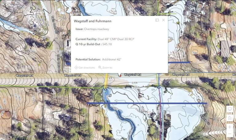
According to Wood Rodgers project manager Harvey Oslick, GIS was instrumental in delivering a high-quality plan while meeting budget and schedule constraints. “One major challenge,” he said, “was that we needed to model 450 culverts without precise survey data.” Though lidar data was available, Oslick explained, it generally did not capture culvert terrain elevations. GIS-estimated elevations guided terrain modifications to get the model to provide reasonable simulations of expected system performance. “This creative use of GIS probably saved three weeks of tedious effort,” Oslick said.

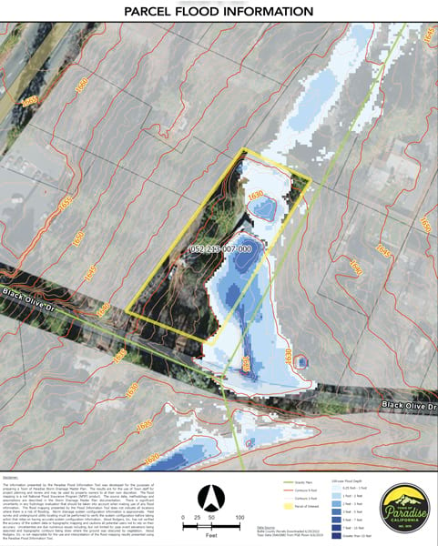
Using a web mapping application configured in ArcGIS Enterprise, the plan also provided design recommendations for areas with known drainage issues, providing a basis for construction cost estimates. Wood Rodgers also developed a flood parcel information tool in ArcGIS Pro to identify potential 100-year flood depths, topographic contours, and existing drainage features on a parcel-by-parcel basis by simply entering an address.
According to Mattox, this has helped support town reviews of reconstruction, new development, and town capital improvement projects. “Our engineering division has been able to run the tool, output the flood information for all 11,000-plus parcels, and pass it along to the homeowner or developer for their use in the rebuild process, saving time and valuable resources,” Mattox said.
Since completion, the plan has received awards from the American Council of Engineering Companies of California and the American Society of Civil Engineers—Sacramento Section.
Today, many streets in Paradise remain lined with empty lots. But new homes are being built, and the opening of a new or returned business is often met with public celebration. Helped by determination, optimism, and a few strategically used ArcGIS applications, Paradise is poised to come back stronger than ever.

