Oysters aren’t just a food source for humans; these mollusks are also estuarine engineers. In addition to filtering the water around them, they create complex hard-bottom habitats that support a diverse ecosystem and stabilize the seabed and shorelines.
This is crucial to estuaries dominated by fine sediments, such as the Chesapeake Bay in the eastern US states of Maryland and Virginia. But oyster populations in the Chesapeake experienced precipitous declines starting in the early 1900s, largely due to overexploitation, habitat degradation, and disease-driven mortality.
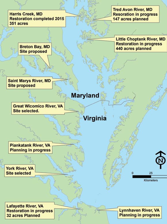
To remedy these losses, the Chesapeake Bay Program is leading the effort to do large-scale oyster habitat restoration and revitalize native oyster populations in 10 bay tributaries by 2025. Centered on sanctuary (i.e., nonharvest) areas, this requires augmenting reef ecosystem habitats, promoting oysters’ water filtration services, and conserving mature oyster brood stocks to ensure that a steady source of wild larval oysters can colonize surrounding areas that are open to commercial harvest.
Given the scale and complexity of this project, the National Oceanic and Atmospheric Administration’s (NOAA) Chesapeake Bay Office focused on geodesigning these new habitats so they could evolve in ways that jibe with the Chesapeake’s natural ecosystems. Employing ArcGIS technology was key to making this work.
Consistency, Communication, and ArcGIS
Harris Creek, Maryland, was the first tributary in the Chesapeake Bay to undergo large-scale oyster restoration. The 350-acre project took three years to plan and implement and was completed in 2015. Dubbed the world’s largest oyster restoration project by The Nature Conservancy, it now serves as a template for the other in-progress and planned oyster restoration efforts taking place throughout the Chesapeake.
Extensive oyster restoration projects like these are typically planned, funded, and implemented by regional workgroups and staffed by federal and state agencies, municipalities, nongovernmental organizations, and academic institutions. With so many distinct actors, consistency and communication are important.
For the Harris Creek project, restoration partners agreed to a series of standard oyster reef success metrics—the most important being a threshold density of 15 live oysters per square meter with a target density of 50 live oysters per square meter.
But achieving those goals isn’t as simple as dropping oysters into the bay and hoping that they flourish. Rather, the team employed ArcGIS solutions to integrate datasets; plan boundaries; create a restoration blueprint; coordinate on-the-ground operations; document progress; and share spatial data among restoration partners, oyster researchers, and other resource managers.
What Makes a Stable Oyster Reef
When oyster larvae come into existence, they are free floating. To thrive, however, they need to settle on clean, hard substrates. In the Chesapeake Bay, most of the original oyster reefs no longer exist, and where they do, oyster numbers are generally depleted.
In places where there are very few or no oyster shells to build on, restoration usually begins by constructing 3D reefs and then either seeding them with juvenile, hatchery-produced oysters or letting wild larvae naturally colonize the area. These new reefs are made of quarried stone, fossilized oyster shells, shells from seafood processors, or crushed concrete. For existing reefs that do have a good supply of natural oyster shells yet lack sufficient live oyster densities, restoration consists solely of adding hatchery oysters.
Whether natural or man-made, reefs need to be located on firm, stable seabed to minimize loss by subsidence. To ensure that this is the case, workgroups rely on bottom mapping and other georeferenced survey data that shows water depth, sanctuary boundaries, navigational aids, and more.
“High-resolution habitat mapping is absolutely essential for successful oyster restoration,” said Dr. Romuald Lipcius, a professor and oyster researcher at the Virginia Institute of Marine Science. Otherwise, “oyster restoration in subtidal waters would be largely [done] by trial and error, which is inefficient and ineffective.”
A Blueprint for Restoration
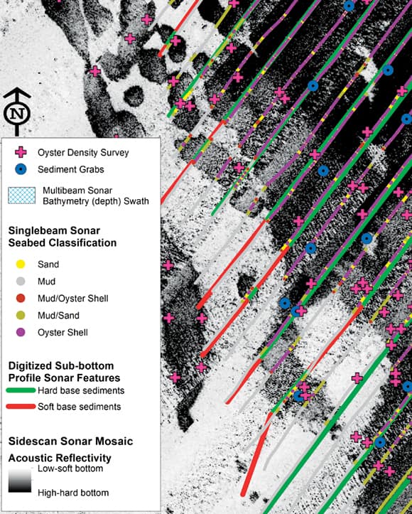
For the Harris Creek project, the Maryland Oyster Restoration workgroup began by creating a feature class in ArcGIS Desktop that identified the distribution of natural oyster shells, as well as hard and soft nonshell bottoms. To do this, the workgroup used side-scan sonar mosaic imagery, which identifies the distribution of hard and soft seabed; single-beam sonar seabed classification points, which distinguish seabed bottom types; and sediment grab point data, which is derived from sediment samples. The resultant habitat polygons were then used to draw up an oyster population survey in ArcGIS Desktop.
With this survey data, the workgroup then employed geoprocessing tools in ArcGIS Spatial Analyst to interpolate the density of live oysters in certain areas. The output grids were reclassed into two bins that identified areas that do not meet the density target (50 or more live oysters per square meter) and areas that do.
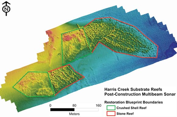
Using the seabed habitat feature classes and the live oyster density grids, the workgroup created a polygon-based blueprint of the entire restoration site. This blueprint defined the site’s boundaries and indicated where reef construction and hatchery oyster seeding would occur.
To ensure that restoration sites are not subjected to the low levels of dissolved oxygen that are prevalent in deeper Chesapeake waters during the summer (since that kills oysters), the workgroup used a course-scale water depth grid to limit the blueprint boundary polygons to depths less than 20 feet. Geoprocessing tools also removed portions of the blueprint that intersected with buffer polygons around navigation aids and channels, marinas, and private docks.
To finalize the boundary geometry for the new reefs, restoration partners conducted subsequent acoustic and ground truthing surveys on the blueprint sites. They did additional depth surveys using sonar to ensure that the reefs were built in areas that were deep enough so they didn’t cause new navigational hazards. They used digitized features from sonar-based sub-bottom profiling surveys to verify that subsurface sediments could support the weight of the new reefs. And they employed new sediment grab points to verify the presence or absence of oyster shells to avoid constructing new reefs on top of existing natural habitats.
Workgroup members then collaborated to review the blueprint polygons in ArcGIS Desktop so they could complete the site boundaries for all the available survey and regulatory datasets. A team of consulting scientists with expertise in oyster restoration then reviewed the blueprint. After that, the Maryland Oyster Restoration workgroup unveiled the project maps at scoping meetings, which were open for public comment.
Once the review process was done, construction and oyster seeding contractors were able to take the coordinates of the restoration sites from the final blueprint to ensure that all materials were placed in the correct locations.
Additional Blueprint Users
Since the restoration project was completed in 2015, the blueprint has helped the Maryland Oyster Restoration workgroup document progress over time. It contains reef construction and oyster seeding dates, reef specifications like height and material, and postconstruction monitoring schedules.
The geodatabase is an ideal environment for storing and integrating the blueprint feature class, population survey data, layers denoting areas that are excluded from the blueprint, annual seeding records for hatchery oysters, and ancillary oyster research.
“Because we were diligent in recording detailed oyster data in the geodatabases, we are able to calculate restored areas [and] track reef types, construction dates, owners, and base material quickly [to put into] reports and charts,” said Karen Dridge, the GIS lead for oyster restoration for the US Army Corps of Engineers, Norfolk District.
The geodatabase also allows the workgroup to efficiently share data with outside organizations. In fact, resource managers and academic scientists who are interested in using the oyster restoration data in their own work frequently request access to the geodatabase.
Exceeding Expectations with Geodesign
By all accounts, the Harris Creek reef restoration project has been a success.
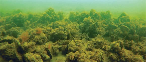
According to postrestoration population surveys, “oyster biomass and productivity results on one-foot-high stone reefs are equal to or greater than [those on] shell reefs,” said Dr. Angie Sowers, an integrated water resources management specialist with the US Army Corps of Engineers, Baltimore District.
Indeed, oyster numbers on Harris Creek’s stone reefs have exceeded expectations. Average oyster densities from all 13 reefs surveyed in 2016 were above the 50-oysters-per-square-meter restoration success target and actually ranged from 130 to 388 oysters per square meter.
It appears that having access to high-quality survey information, along with the ability to integrate a variety of spatial datasets during the planning phase, is highly effective for restoring oyster habitats. This is surely geodesign at its best.
For more information, contact David Bruce at david.bruce@noaa.gov.
