A new study by the National Geospatial Advisory Committee (NGAC) warns that the United States’ rapidly aging infrastructure is already creating safety hazards, diminishing quality of life, heightening vulnerability to natural disasters, and impairing economic growth. Infrastructure renewal is a national imperative for the United States, and it requires cooperative and coordinated action by the private sector and all levels of government.
The NGAC study, entitled Geospatial Information: The Key to Smart Infrastructure Investments, highlights the crucial role that geospatial technologies play in supporting infrastructure planning and development. It also gives recommendations on how to maximize returns on infrastructure investment.
As a member of NGAC, I feel that this report merits the attention of the entire geospatial community. That is why I am dedicating this column to summarizing its findings and recommendations.
Informing Infrastructure Renewal Effectively

As the United States begins to reprioritize the rebuilding of its infrastructure, the governments and companies involved will need accurate and reliable spatial data of all types to ensure that scarce dollars are spent in the most efficient and effective ways possible. Knowing where infrastructure is located, how different pieces relate to one another, and where the critical dependencies lie are required first steps for making good financial decisions.
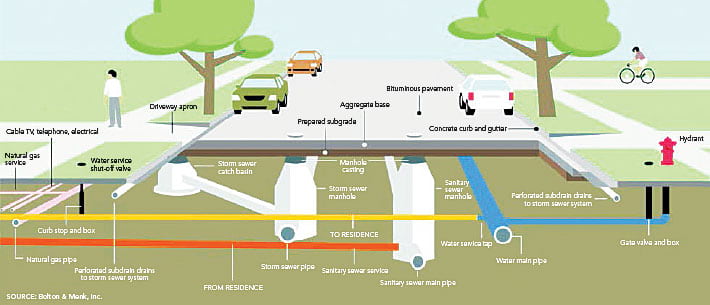
Geospatial information and technologies make it easier to discern and understand the precise location of every facet of infrastructure, from what’s underground to what’s overhead. Fortunately, tremendous advances in geospatial technologies—many of which have been driven by the commercial sector, including Esri—have made these tools far more powerful, accessible, and usable. Employing technologies such as intelligent, real-time GIS and GPS maps to prioritize, plan, and execute new infrastructure projects can help optimize public and private infrastructure investments and avoid inefficiency and waste.
Maps created using GIS, GPS, and aerial imagery can be generated and updated rapidly. Additionally, they typically contain detailed information not only about current and planned infrastructure improvements but also about the contexts surrounding them. For example, if a local government wants to visualize all the pothole locations in its downtown area, it can use GIS to see them all mapped out—and then add useful data layers, such as traffic flow and pavement type, to pinpoint what’s causing them and try to figure out how to stave them off in the future. These maps can be shared digitally across sectors to improve project planning and operations. And that is just one example of the many geospatial technologies that can effectively inform infrastructure renewal.
To get the myriad elements of new national infrastructure programs to coalesce, investments need to be smart, timely, data driven, and efficient. They must also account for society’s current and future needs in a sustainable way. Significantly, the planning and design processes will generate new jobs and continued innovation in the GIS and geospatial technology sectors.
Creating and Maintaining Geospatial Databases and Models
If governments and companies use geospatial technology to thoughtfully coordinate infrastructure planning for mass transit, public spaces, and low-impact development, then the United States will be able to economically cultivate smart, resilient communities with improved qualities of life.
Geospatial technologies can be used to effectively manage infrastructure assets over their entire life cycle—from design and construction to operation and maintenance. They can engage local communities from the get-go. They make 3D infrastructure modeling possible, which enables investors and operators to visualize projects during the planning process and better understand their costs and benefits. They can identify and resolve conflicts quickly and holistically.
Geospatial technologies are essential to managing infrastructure assets such as storm water drains, gas pipelines, tunnels, bridges, the electrical grid, and broadband. The sophisticated geospatial analyses they facilitate, integrating space and time management, help infrastructure planners and operators cope with highly complex projects. Thus, creating and maintaining large-scale geospatial databases and models is important to intergovernmental coordination and should be supported by national research funding agencies.
Building the Infrastructure of the Future
The NGAC report emphasizes that all levels of government, as well as private entities, have a role to play in using geospatial technologies to enhance the efficiency of infrastructure renewal. Governmental roles entail
- Supporting foundational data, such as remotely sensed imagery, address data, and other National Geospatial Data Assets.
- Promoting data sharing standards to reduce duplicate efforts and enhance data sharing.
- Using geospatial data and tools, including the Federal Geographic Data Committee’s GeoPlatform, to plan, manage, track, and communicate the results of a national infrastructure initiative.
- Ensuring that infrastructure grant funds can be used for geospatial data, systems, and services. Such grants for geospatial technologies are as important as investments in steel and concrete.
- Modernizing the national governance of geospatial data and programs to reduce duplication and enhance efficiency.
The Esri community is also extremely well positioned to help build the United States’ smart infrastructure of the future. To achieve this goal, the entire GIS community—including GIS educators, engineers, geographers, planners, surveyors, GIScientists, researchers, and technicians—will need to work together. That is the only way this country will be able to ensure that the next generation has safe, smart infrastructure.
Read the full NGAC report and see a list of NGAC subcommittee members who contributed to it.
Contact Doug Richardson at drichardson@aag.org.
Read other articles in the Crossing Borders series.


