Norfolk, Virginia, is no stranger to the hazards of climate change. Flood events—including rapid rainfall, river floods, rising tides, and storm surges—have become more intense. In recent years, these natural hazards have caused significant disruptions to transportation, impacting residents’ quality of life. The disruptions affect all modes of road transport and frequently upend economic and social activities in the area.
Recognizing that sea level rise will continue to be a reality in the region, the City of Norfolk is building resilience against climate-related hazards. Through RISE, a nonprofit economic development organization that helps coastal communities adapt to a changing climate, the city partnered with Esri startup partner FloodMapp to implement flood modeling technology that delivers inundation data quickly and at more than 90 percent accuracy.
“As our streets flood more often due to climate change, we need to find a sustainable way to alert community members about the risks they face,” said Kyle Spencer, deputy resilience officer for the City of Norfolk. “FloodMapp’s technology provides affordable, citywide situational awareness that current solutions, such as sensor networks alone, don’t offer.”
Lots of Information, But No Actionable Intelligence
Norfolk, which is home to 235,000 residents, encompasses 66 square miles and has 144 miles of shoreline along lakes, rivers, and the Chesapeake Bay. Much of this waterside land consists of residential neighborhoods.
Prior to working with FloodMapp, the city had access to a lot of information from flood sensors and static flood studies. But given the speed and scale at which current flood events are unfolding, staff needed more actionable intelligence to be able to respond to sudden storms, surges, and floods.
The city sought help from RISE, which put out a call through its Urban Mobility Resilience Challenge to get Norfolk equipped with flood modeling technology that it could use to help navigate traffic around flooded roads. FloodMapp’s solutions—which provide real-time, street-level predictions and alerts for flooded roads—turned out to be the scalable, cost-effective system that the City of Norfolk was looking for.
Street-Level, Property-Specific Flood Data
Coastal Virginia is not alone in suffering the impacts of increasingly devastating floods. Last year, communities in Australia and Pakistan experienced some of the worst flooding that’s ever been documented. Flooding is among the most frequent, dangerous, and costly natural disasters. The risks for drivers are particularly grave. About half of all flash flood-related fatalities in the United States occur in motor vehicles, according to the Federal Emergency Management Agency (FEMA). And auto insurance claims for flood damage in the United States averaged $3.5 billion annually from 2005 to 2014, according to Cover, an insurance technology company.
FloodMapp’s mission is to improve safety and prevent damage from flooding on a global scale. Its proprietary flood modeling technology, DASH (which stands for Dynamic Automated Scalable Hydro-informatics), accesses live rainfall, river, and tide gauges to feed its hydrologic and hydraulic models. The models are powered by artificial intelligence (AI).
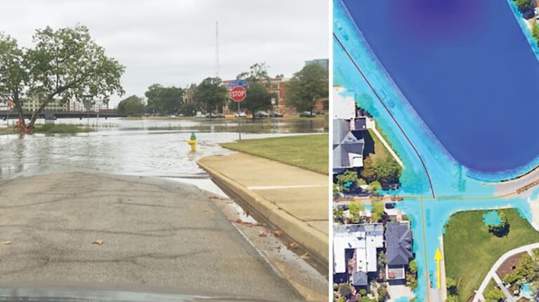
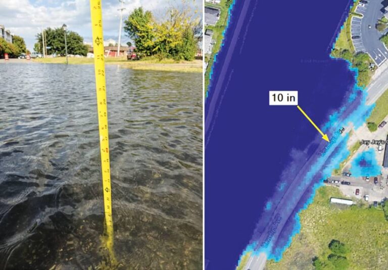
DASH produces updated model outputs of coastal conditions at state and national scales in a matter of seconds, whereas traditional 2D hydraulic models can take hours or days to produce a single catchment. This solves the historic problem of there being long delays in delivering accurate inundation data, which can hinder situational awareness. What’s more, the dynamic flood inundation and depth models that DASH produces have street- and property-level accuracy.
With this technology, FloodMapp can supply customers with live flood intelligence before, during, and after flooding events. Additionally, the company’s other products—ForeCast, NowCast, PostCast, and RoadSafe—are live mapping feeds that integrate seamlessly with ArcGIS Pro and ArcGIS Online to support emergency managers working for governments and in the private sector.
Each product provides dynamic, street-level, property-specific flood intelligence that can be scaled up to a national view. Emergency managers can overlay FloodMapp’s models with their existing ArcGIS data layers on people, property, and critical infrastructure to provide accurate situational intelligence. With this information at hand, they can then issue flood warnings, coordinate evacuations, protect critical assets, reroute traffic, safely deploy response resources, and quickly target recovery actions.
For Norfolk, FloodMapp focused on using its technology to help city officials alert residents of potential flood hazards and establish targeted road closures. The project was made possible by a grant from RISE, which is funded through the US Department of Housing and Urban Development’s Community Development Block Grant Program and administered by the Virginia Department of Housing and Community Development.
Dynamic Solutions for Fast-Changing Events
A team at FloodMapp worked with staff members at the City of Norfolk to understand the detailed requirements of meeting this challenge. After the teams drew up a plan, the first step was to implement NowCast, which delivers near real-time flood inundation extents and depths as a mapping service. This allows city staff to see flood inundation models based on tidal and rainfall observations that get updated every 15 minutes and are accurate to within inches.
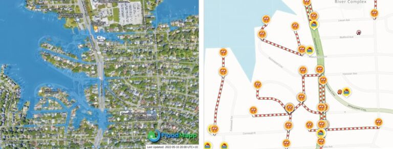
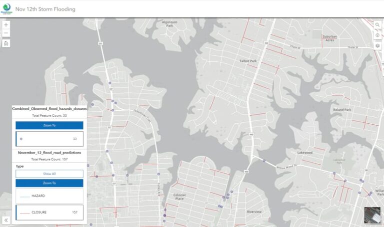
Next, the FloodMapp team set up RoadSafe, a powerful analytics service that predicts which roads will flood, based on the inundation data from NowCast. Flood depth thresholds, developed in collaboration with the city, are used to define road hazards and road closures based on the depth of flooding over each road segment. The solution was then delivered to the City of Norfolk’s ArcGIS Online organization, where staff members can view live road closures and road hazard segments that get updated dynamically as a flood event unfolds.
Additionally, the FloodMapp team worked with navigation company Waze to integrate RoadSafe’s flooded-road predictions with the Waze app via the Waze for Cities platform. This enables the City of Norfolk to notify app users of roads that have the potential to flood by placing flood hazard icons on local Waze maps.
“The successful integration of FloodMapp’s technology into Waze has the potential to save property and lives and help coastal communities worldwide adapt to the threats from climate change,” said Paul Robinson, executive director of RISE.
A Common Operating Picture for Flood Events
Because FloodMapp is integrated with ArcGIS Online and ArcGIS Pro, City of Norfolk staff members and other stakeholders are able to use NowCast and RoadSafe to develop a common operating picture during a flood event. The solution provides the City of Norfolk and staff at the Emergency Operations Center with hyperlocal flood data in real time. This vital situational awareness helps inform emergency managers and public works officials as they respond to flood events, so they can craft accurate community messaging and make safe and effective plans.

The integration with Waze also allows motorists to contribute feedback to the program. They can give a notification a thumbs-up in the app or utilize the app’s flood hazard reporting feature. This powerful, crowdsourced ground truth data enables city staff and the team at FloodMapp to monitor the flood models’ performance in real time. This quality assurance is valuable for ongoing validation, as FloodMapp is continually seeking to improve its flood models and road closure predictions.
Since launching the system for Norfolk residents in October 2021, Waze users have confirmed more than 4,300 flooded roads predicted by RoadSafe. Drivers have provided nearly 9,500 thumbs-ups to validate FloodMapp’s predictions (which average 2.2 and top out at 72 confirmations per hazard). Not only do these crowdsourced observations aid in validating and improving the models, but the engagement statistics also indicate that they are helping thousands of drivers navigate around flooded roads. Those drivers have prevented losses and damages to their vehicles and have been able to get home safely to their families.
The flood prediction solutions that FloodMapp implemented in Norfolk have provided the city with an infusion of innovation as it continues to adapt to the increasingly dire effects of flood-based hazards. The solutions are highly responsive to local resilience issues and can be rapidly adapted to the needs of other communities.

