Dengue is a dangerous disease that mosquitoes transmit to humans. Occurring more often in tropical and subtropical climates, dengue infects approximately 400 million people each year, making it one of the most common mosquito-borne diseases worldwide. In mild cases, it can cause fever and flu-like symptoms, and in more serious cases, bleeding and even death.
Puerto Rico suffered more than 6,000 dengue cases in 2024, exceeding historical figures for the area, according to Puerto Rico health secretary Carlos Mellado López. This outbreak prompted health officials to declare a public health emergency in March 2024, joining other Latin American nations such as Brazil and Peru that are coping with their own outbreaks.
To find mosquitoes transmitting the disease throughout Puerto Rico, the Puerto Rico Vector Control Unit (PRVCU) developed a comprehensive dengue tracking and suppression program. Staff from the PRVCU installed an extensive network of mosquito traps—thousands of them—across the island to help locate the invasive pests. Mosquitoes trapped in this network are tested for dengue’s genetic markers, and those that test positive are traced back to specific traps. This georeferencing establishes where and when active dengue transmission has occurred and has proved to be an invaluable tool for targeting interventions to those specific areas.

ArcGIS provides the technological foundation for Puerto Rico’s mosquito suppression program. By using an array of Esri products, including ArcGIS Pro, ArcGIS Workforce, ArcGIS Field Maps, and ArcGIS Online, PRVCU collects critical data in the field to track this invasive pest. Control crews can then gather the affected traps and kill the vector mosquitoes—the ones capable of causing harm—that are reproducing and transmitting pathogens in that location.
A Difficult Disease to Track
The data collected from each person infected with dengue can provide some details about when the person was bitten but not precisely where they were infected. A human can be bitten and infected by mosquitoes in any one of several locations, making it difficult to discern the infection point.
Additionally, the time lag between when a person is infected and when the infection is confirmed and reported may be too long to help fight an outbreak. Once a person is bitten by an infected mosquito, there is a one-week incubation period before they begin to exhibit symptoms. When symptoms appear and the person goes to the doctor, the doctor takes a blood sample and sends it to the territorial health laboratory for testing. If the person tests positive, this is relayed to Puerto Rico’s vector control team about a week later.
By the time someone’s blood sample is tested, the mosquito that originally caused the infection has likely infected other people. These individuals may become viremic, meaning the virus is present in the blood, which can, in turn, infect a new generation of mosquitoes. As this cycle repeats, a vector control team that relies on human case data for guiding control efforts may not have up-to-date information. Moreover, most infected people never go to the doctor. It is estimated that 75 percent of all infections are never medically attended.

A Targeted Approach to Finding Mosquitoes
To target dengue-carrying mosquitoes, authorities need information about the mosquitoes themselves. Puerto Rico’s mosquito suppression program consists of three steps to find and exterminate infected mosquitoes: surveillance intervention, Autocidal Gravid Ovitraps (AGOs), and Wide Area Larvicide Spray (WALS). AGOs are sticky, pesticide-free traps that attract and kill female mosquitoes that lay eggs to help control and monitor mosquito populations. WALS is an approach to larvae control that uses naturally occurring bacterium to kill the mosquito larvae in water sources.
“Surveillance intervention involves setting traps for seven days and examining the collected mosquitoes,” explained César Piovanetti Fiol, chief information officer of the Puerto Rico Science, Technology & Research Trust, the private nonprofit organization that oversees the PRVCU initiative. “[AGO] traps are low-maintenance, environmentally safe traps for mosquito eradication. The WALS method involves dispersing larvicides on vegetation and buildings to control mosquito populations.”
For the island-wide network of traps, staff from the PRVCU maintain a detailed chain of custody that documents who handles each collected trap. Each trap has a unique identification code, so it can be tracked from the field to the processing station, the molecular laboratory, and finally the mapping center. This is where the trust’s GIS team produces treatment maps for the organization’s vector control teams, which visit and service the traps on a weekly basis. In addition, a quality management system ensures that no traps are missed or lost and that all standard operating procedures are followed.
ArcGIS Enhances a Complicated Process
As established Esri technology users, the PRVCU has deployed several solutions to aid the mosquito abatement program. Vector control unit staff use ArcGIS API for Python with geoprocessing tools in ArcGIS Pro to generate potential locations for surveillance and intervention traps.
Staff geocode the locations of the traps, and those that require maintenance are automatically loaded each day into assignments in ArcGIS Workforce thanks to the Python API. This ensures that each vector management technician knows the area and the number of traps that need to be installed. The Python script has several variables that dictate what the team will do with the traps, such as perform maintenance.
, notes, and user ID. Both screens utilize the same location data.")
“ArcGIS Workforce is integral to the program’s success by providing a structured and efficient way to manage field operations, ensuring that tasks are completed accurately and on time,” said Piovanetti Fiol.
Once the team locates dengue-infected mosquitoes, mobile workers use ArcGIS Field Maps to identify where to install the AGO traps. A map in Field Maps is configured to integrate with an ArcGIS Survey123 questionnaire to help mobile crews document trap installation on residential premises. The team also developed an ArcGIS Arcade script to identify any AGO traps that require maintenance, which is needed every eight weeks following installation.
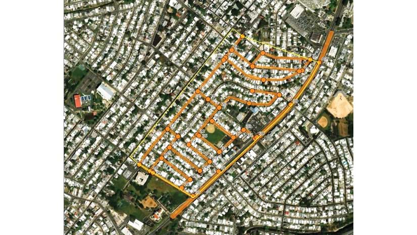
To kill mosquito larvae in water sources using the WALS approach, a truck sprays larvicide over vast areas, including on buildings and vegetation. ArcGIS Navigator determines the most efficient route for the truck to take. After spraying, field technicians complete a Survey123 form that provides details on the location of the operation, the wind direction and temperature at the time of spraying, and the time the larvicide spray was applied. This information gets put into a report for the Puerto Rico Department of Health.
“Our sophisticated Esri-based trap information management system is practical, reliable, and the centerpiece of operations,” said Piovanetti Fiol.
Success Shows in Low-Income Housing Developments
The success of this program is especially evident in Puerto Rico’s low-income housing projects, called residenciales. Residents of these neighborhoods contract dengue at a rate four times higher than people who reside in other housing types, according to Dr. Grayson Brown, executive director of the PRVCU. It’s not uncommon for 2–3 percent of residents in these complexes to require medical attention for dengue each week.
In residenciales where vector control hasn’t taken place, up to 90 percent of the traps may contain mosquitoes that test positive for dengue. However, the PRVCU’s geospatial dengue tracking program enables staff to respond quickly and target the residenciales that have dengue-transmitting mosquitoes.
The desired result is for the number of dengue-positive mosquitoes to drop to zero within several weeks of targeted interventions, and for human cases to also fall to near zero within several weeks of the last dengue-positive mosquito being detected. Having the ability to target the mosquitoes themselves, rather than pursue human cases reported weeks later, goes a long way toward achieving these goals.
-
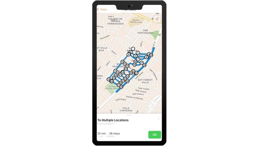
During Wide Area Larvicide Spray (WALS) operations, technicians use ArcGIS Navigator to find the most efficient route for covering vast areas.
Centralizing All Geospatial Data
The Puerto Rico Science, Technology & Research Trust has used Esri products since the inception of its island-wide vector control project eight years ago. The organization’s enterprise geo-database stores approximately 500,000 records related to surveillance interventions.
“We employ ArcGIS Enterprise to centralize geospatial information for all interventions, ensuring data integrity, facilitating access, and enabling users to manage large volumes of data efficiently,” said Alberto Millan Melendez, GIS manager for the Puerto Rico Science, Technology & Research Trust.
The project is in direct collaboration with the US Centers for Disease Control and Prevention (CDC). This means that the PRVCU and the CDC Dengue Branch jointly evaluate all protocols and criteria for the installation, management, and maintenance of mosquito traps and larvicide spraying procedures.
Sharing implemented solutions with the CDC and other stakeholders is a requirement for all projects. The trust uses ArcGIS Online to easily share data, maps, and web apps with external agencies. The PRVCU also employs ArcGIS Dashboards extensively to collect and visualize data for various agency projects. This allows the data to be displayed in an easy-to-understand format that technical support staff, decision-makers, and others can readily understand and update.
The successful application of ArcGIS technology to find and destroy dengue-carrying mosquitoes has led the PRVCU to expand its use of GIS. PRVCU’s next step is upgrading its ArcGIS Enterprise deployment to expand web editing workflows and incorporate ArcGIS Knowledge, according to Millan Melendez. The PRVCU will also provide ArcGIS access to all programs within the Puerto Rico Science, Technology & Research Trust to integrate GIS data and capabilities into future projects.