Esri partners help organizations streamline operations, collect and optimize data, plan land-management strategies, and more. See how four partners aided two utilities and two government agencies in updating their GIS implementations to manage utility assets, empower real estate investors, address public health requirements, and restore a historic district.
Gas Distributor Enhances Services, Field Safety with Mobile GIS
Hope Gas, a gas utility in West Virginia, needed a mobile solution to view and collect data for assessments along more than 6,900 miles (11,104 kilometers) of pipelines. These assessments typically relate to gas leaks, damage due to weather and outside forces, and overgrown rights-of-way.
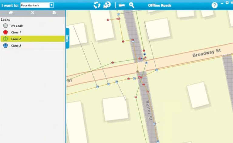
The solution had to operate on the company’s field laptops, which run on Windows 11. It also needed to work in areas with and without cellular connectivity. And it had to be created within three months to properly service the company’s approximately 125,000 residential, industrial, and commercial customers.
Initially, Hope staff had planned to use Windows Subsystem for Android to deploy ArcGIS Field Maps. But various complications led Hope to seek a different solution. In late 2023, Hope began working with RAMTeCH.
RAMTeCH’s gMobile solution, powered by ArcGIS Maps SDK for .NET, enabled RAMTeCH staff to quickly create a native Windows app with common GIS functions, including the ability to view asset attributes, locate addresses, and search for assets by location or attribute. RAMTeCH added the ability to perform damage assessments and place gas-leak and visual inspection points on a map. The solution also included offline data functions and asset attribute forms.
The gMobile solution uses forms that staff at Hope and RAMTeCH created in Field Maps using ArcGIS Arcade expressions. gMobile is built on a framework called the Prism Library, which allowed Hope’s gMobile app to be divided into independent modules for fast and flexible development, testing, and deployment.
Staff members at RAMTeCH and Hope also used gMobile’s proprietary data synchronization process—built with the ArcGIS Enterprise feature services sync capability—which scales to allow near real-time data synchronization from hundreds of users. Integration of Esri feature services and SAP software utilizing the Open Data Protocol (OData) enables notifications in SAP that are then managed by internal Hope resources.
Hope deployed gMobile in January 2024, which met the utility’s core requirements within its three-month time frame. With Hope’s plans to further expand the app to support an SAP-integrated pipeline damage-reporting process, the solution continues to aid the utility company in achieving its business objectives and meeting future needs.
Transforming Saudi Arabia’s Real Estate Sector with GIS
Established in 2016, Saudia Arabia’s National Housing Company (NHC) is the investment arm of the country’s Ministry of Municipal and Rural Affairs and Housing, which manages urban planning and housing development. In May 2020, the NHC began a new chapter under state ownership. When this happened, the government directed the company to better empower the country’s private sector. Digitizing NHC operations and services was a priority, but this was complicated by the fact that the company had fragmented databases across various platforms.
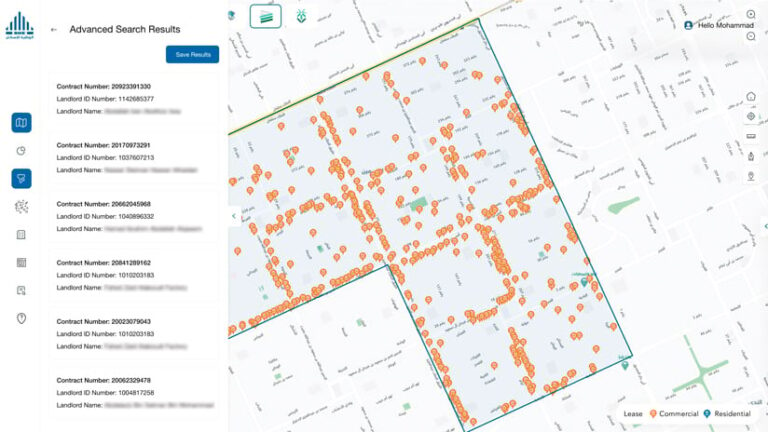
To help with this project, NHC enlisted Khatib & Alami. Using GIS technology such as ArcGIS Pro, ArcGIS Enterprise, and ArcGIS Dashboards, along with Esri’s geospatial artificial intelligence (GeoAI) and geocoding services, Khatib & Alami and NHC created a comprehensive geospatial database that integrates several of NHC’s real estate management platforms. The database also incorporates numerous new, innovative functions and drives real estate planning, use, and investment.
As part of this effort, the team developed API services for NHC’s rent index app. Employing geocoding and map services in ArcGIS Enterprise together with spatial analysis, this solution provides a detailed overview of property rent prices. This helps local real estate service providers make more informed and strategic decisions by allowing them to select and evaluate locations.
Incorporating GeoAI models developed using ArcGIS Pro deep learning tools was key in helping NHC distinguish between vacant and developed properties. This supports Saudi Arabia’s efforts to foster the development of unused land by encouraging private sector participation and creating investment opportunities. Real estate investors can now evaluate land, determine annual fees, and assess property ages using archived satellite imagery from World Imagery Wayback in ArcGIS Living Atlas of the World.
The team also employed Esri’s ArcGIS Geocoding service and the spatial extract, transform, and load (ETL) tool to allow users to find addresses from locations or vice versa.
These technological advances have provided NHC’s customers and stakeholders with valuable map-based real estate information. Visualizing the results on dashboards built with ArcGIS Dashboards has empowered more informed decision-making in real estate investments and development projects. These enhancements have led to significant cost savings and improved operational efficiency, driving smarter strategies and better outcomes overall.
Using GeoAI to Make Drinking Water Safer
When lead and copper get into drinking water, the health effects can be serious, ranging from nausea to brain damage. To help prevent these risks, the US Environmental Protection Agency recently revised its Lead and Copper Rule and mandated that all US water utility companies identify and inventory their lead service lines by October 16, 2024.
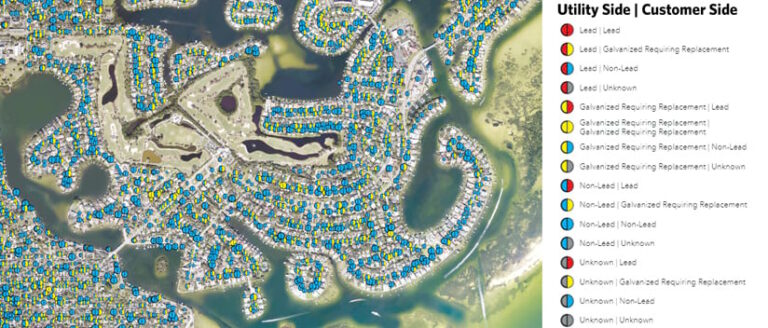
As with many other water utility providers around the United States, the City of St. Petersburg, Florida, had a lot of work to do. It has about 96,000 service lines in its water system, and when the rule revisions were announced in 2021, only about 1 percent of these lines had a known, documented material type.
While the city had a rich database of work activities that had been performed on its assets and there was plenty of valuable information in the database, much of it was in free-form text fields. With about 500,000 records, an analyst team would have spent countless hours reviewing and classifying text-based data—a process that also would have had a high potential to introduce errors.
With help from HDR and the GeoAI toolbox in ArcGIS Pro, city staff used geospatial artificial intelligence to train a text classification model to read through the database. Via this process, staff were able to pull a variety of location-specific data from the records, including:
- If and when a service line had been replaced
- Known material types for original or replaced service lines
- Whether a service line had been replaced on the city side, the homeowner side, or both
Staff used the toolbox to incorporate known material types from the database with other key variables such as building construction and mainline pipe installation dates. From there, a citywide presence prediction model generated a probability distribution for each material type at each service line location to help staff create a service line inventory and prioritize field investigations.
By using the GeoAI toolbox, the team increased the efficiency and accuracy of text classifications. It also created a repeatable model that the city can quickly use when records need to be assessed—helping St. Petersburg not only comply with federal regulations but also reduce risk from lead and copper contamination.
Automatic Change Detection Helps Restore a Jewel from Saudi Arabia’s Past
Located on the outskirts of Saudi Arabia’s capital of Riyadh, the city of Diriyah was once a center of education, commerce, and culture, and is the original home of the Saudi royal family. Following the Siege of Diriyah in 1818, this historically rich area was largely deserted until 2000. But in 2010, Diriyah’s At-Turaif district was declared a UNESCO World Heritage Site, and in 2017, the Saudi Arabian government established the Diriyah Gate Development Authority (DGDA) to restore and transform Diriyah into an international tourist destination and an even greater source of pride for Saudis.
As the geospatial technology partner in fulfilling this mission, Quality Standards for Information Technology (QSIT) worked with DGDA to create a geospatial strategy and road map, with the goal of building a digital twin in the next two years to help empower DGDA’s decision-making.
Using ArcGIS Online and ArcGIS Workflow Manager, staff from QSIT developed one platform to support seamless collaboration with DGDA and another to manage and automate the validation, conversion, and updating of urban planning data. QSIT staff used FME Flow from Safe Software (another Esri partner) to automate the input and transmission of DGDA’s data. QSIT made this consistent by adhering to computer-aided design (CAD) and building information modeling (BIM) standards. ArcGIS Urban helped DGDA staff visualize urban planning data and compare different scenarios.
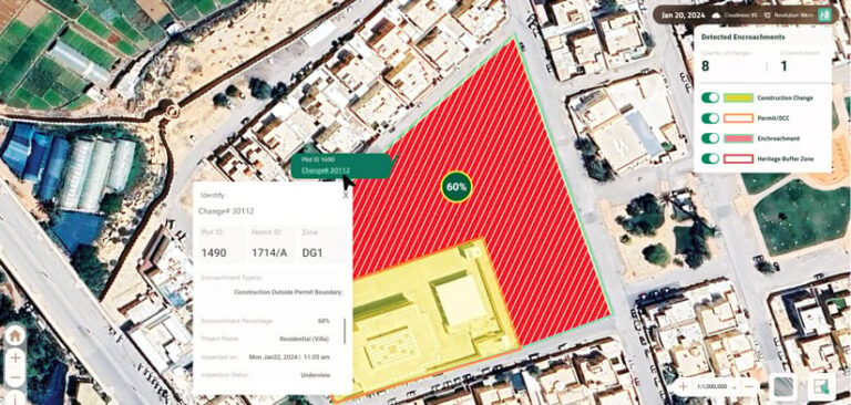
Using Esri’s deep-learning models and high-resolution 50-centimeter multispectral optical satellite imagery, QSIT and DGDA staff also developed a way to automatically detect property changes such as construction violations and encroachments in DGDA’s 2.7-square-mile (7-square-kilometer) jurisdiction. QSIT staff then integrated these results with DGDA’s Field Works Inspection Platform, developed with ArcGIS Runtime SDK for iOS and ArcGIS Runtime SDK for Android, to help manage year-round inspection missions, field-based inspection activities, and ad hoc requests.
Today, midway through the road map schedule, DGDA has already seen the value of geo-enabled solutions. The visibility of its workflows has improved; it has better control over the area it supervises; and staff are saving money, time, and effort. With QSIT developing more functionality, including real-time capabilities and additional apps and analytics, DGDA is poised to further benefit from GIS technology.
