A man entered the Soldier Readiness Processing Center, which prepares soldiers for deployment, at Fort Hood, Texas, on November 5, 2009. He sat at an empty table, paused for a few seconds, stood up, shouted, and began firing a weapon.

Within 10 minutes, 13 people were dead and more than 30 others were injured. Two minutes and 40 seconds after the first call to 911, first responders from on base were at the scene. A minute and a half later, officers shot the suspect. Ambulances arrived two and a half minutes after that, once the suspect was taken into custody.
Although emergency responders from off base arrived at Fort Hood quickly, there was no way for them to locate the victims. That is because Fort Hood, like many US military bases, did not have standard street addresses like the ones found in cities and towns across the United States.
Soon after the Fort Hood shooting, the US Navy decided to create standardized addresses and improve the Navy Emergency Response Management System using enterprise, geospatially enabled dispatch capabilities supported by Esri technology.
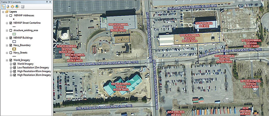
This project, called the Navy Emergency Management Addressing Project (NEMAP), gives naval facilities conventional addresses and maps out all the streets on base. It then incorporates this data into dispatch systems at the navy’s regional dispatch centers, which route all 911 calls placed on naval installations. The navy is also sharing this data with local governments near the bases to improve collaboration during crises.
Upgrading the Navy’s 911 Systems
Independent reviews of the Fort Hood shooting found that most military installations did not have sufficient 911 capabilities. In 2010, the US Secretary of Defense directed all Department of Defense facilities to implement Enhanced 911 (E911) services, which automatically notify dispatchers of a caller’s location, even if the caller is using a cell phone, and broadcast emergency notifications to select geographic locations. The goal was to create a military response system that works in tandem with local government systems to handle emergency situations more quickly and efficiently.
To do this, the Commander, Navy Shore Installations Command ordered that standardized base addressing—routable street centerlines and corresponding addresses—be set up in a GIS for every facility at every navy installation in the United States. Working with services company Serco, Inc., and location technology consulting firm GISi (an Esri Platinum Tier partner), the Space and Naval Warfare Systems Command Systems Center Pacific (SSC Pacific) executed the NEMAP effort by developing the addressing data to integrate into the Navy Emergency Response Management System.
Collecting and Managing Data Using ArcGIS
Designing a standardized addressing system was not easy. The NEMAP team had to develop and process thousands of address points and street centerlines for more than 65 navy commands and 300 navy sites, and the data had to be agile and scalable.
SSC Pacific implemented Esri’s ArcGIS for Desktop, ArcGIS for Server, and ArcGIS Online to manage, store, and edit the address data. To ensure and retain the quality of the information being gathered—especially the topology of the street centerlines—the team used ArcGIS Data Reviewer, an ArcGIS for Desktop extension. It also employed Esri Platinum Tier partner GeoComm’s GeoLynx DMS, which automated the creation of centerlines and assigned addresses, to add another level of data integrity.
Additionally, because state and local governments were providing much of the addressing guidance and because the NEMAP data had to integrate easily into local government GIS and response systems across the country, the team modeled its centerline and address point data after Esri’s ArcGIS for State and Local Government emergency response solutions. This ensured that the data would be compliant with the National Emergency Number Association and the Federal Geographic Data Committee.
NEMAP’s Secret Sauce: Workflow
When the project began in 2013, the team developed a workflow, dubbed the NEMAP Secret Sauce, that gelled as the project progressed.
First, the team collected existing GIS data on the navy’s structures and facilities. It analyzed each installation and identified any unnamed roads and special locations such as restricted areas, special storage units, and fenced-in facilities. Next, the team went out into the field to verify any questionable sites and devised addressing systems for them. Finally, the team established a rapport with local government authorities and navy stakeholders to come up with an addressing plan that would match each base’s local master street address guide, which emergency responders use to find specific addresses.

This addressing gives both the navy and local governments a set of 911-compliant addresses and topologically correct street maps for every place on military bases.
Best Practices Unique to Military Addressing
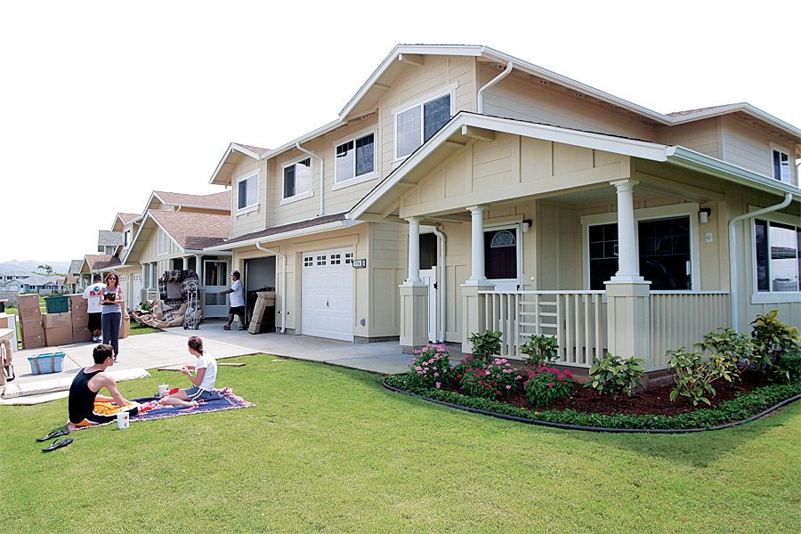
Implementing the addressing system, however, was far trickier than collecting the data. Some bases have historic building numbers while others have implemented their own addressing systems, and some of these needed to be changed to match local emergency response systems—including, in certain cases, addresses for base housing. Creating routes through weapons storage areas was problematic, as was determining whether airfields needed to be mapped out like streets. The team also had to pay special attention to facilities that the general public could access, since these are not completely under navy control and may have distinct addresses. And then, after all that, each military installation needed to physically change building numbers and street signs, update mailing addresses, and modify most public relations materials.
Because of these unique issues, the NEMAP team developed a set of best practices that suit the navy’s needs.
Paramount to the team’s concerns was that the people who live and work on base experience the lowest impact. Thus, every effort was made to preserve established addresses, especially for family housing, publicly accessible facilities, and the commanding officer’s building.
For groups of structures—such as clusters of buildings that are accessed via one location, facilities that are gated or fenced in, and weapons storage areas—the team found it beneficial to give them all one address. It treated these like apartment complexes by assigning each structure a unit number. This practice satisfied security personnel because it ensured that emergency responders would only enter through one access point, accompanied by an escort.
Additionally, many bases have common, unnamed routes that cut through the installation; rarely used trails in isolated rural areas; and, occasionally, long access roads that lack location points such as driveways. For these, the team implemented a generic naming convention that identified what these were (a road or a driveway, for example), which allowed the navy to quickly identify where actual names were needed.
Collaboration Made Possible by ArcGIS Online
To make all of this work, the team had to seek input from navy stakeholders such as the housing, supply, public works, and safety departments; Real Property and the GeoReadiness program; and, in some cases, even an installation’s commanding officer. It also had to collaborate with local government authorities such as emergency managers, addressing coordinators, planning departments, and local fire departments.
Using ArcGIS Online, SSC Pacific constructed a collaboration website, the NEMAP Workspace, where local government authorities and any navy stakeholders that conduct reviews can access and view interactive maps of their areas of interest. They need little to no prior knowledge of GIS to successfully navigate the website and its maps.
The navy and local governments can collaborate in one central section of the website called Review Maps and use map notes to highlight areas of interest or concern on a map. As data is completed and stored, it is published to the Facility Address Search Tool and is available for all long-term NEMAP stakeholders to quickly reference if they need an address.
Saving Lives with Better Emergency Management
All navy bases in the continental United States now have 911-compliant addresses and routable street centerlines. NEMAP has given addresses to about 35,000 facilities at more than 300 navy sites and has processed more than 13,000 miles of street centerlines.
NEMAP is a small part of the overall infrastructure of the Navy Emergency Response Management System, but the data it has gleaned is essential to the system’s effective operation. The Navy Emergency Response Management System currently includes three main functions: 911 routing and management service, computer-aided dispatch, and GIS. When the navy eventually transitions to an enterprise format, the system will be centralized and could include real-time mobile field dispatch capabilities.
Dispatchers at the navy’s regional dispatch centers will no longer have to rely solely on asking, “What is the location of your emergency?” They will be able to see the location of the emergency on their computers or mobile devices as the call comes in. That is how NEMAP data will save lives.
For more information on NEMAP, email Ronald Anderson, the NEMAP contract lead for the Space and Naval Warfare Systems Command Systems Center Pacific.
About the Authors
Amy Hrdlicka, GISP, is a geospatial project manager at GISi. She has been supporting geospatial applications for the navy for more than seven years. Her work focuses on facilities, asset management, and emergency response for the GISi Navy program. She can be reached at Amy.Hrdlicka@gisinc.com.
Marvin Garland, GISP, works for Serco, Inc., supporting the Space and Naval Warfare Systems Command Systems Center Pacific. He is the geospatial/GIS subject matter expert and project lead for the Navy Emergency Response Management System and NEMAP. He can be reached at Marvin.Garland@serco-na.com.

