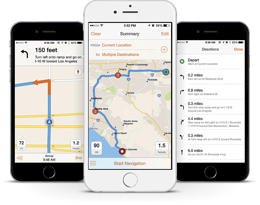
Many consumer navigation solutions can take people from point A to point B, but businesses and organizations need more than that. They require support for commercial workflows such as inspections, service and repair, and local parcel pickup and delivery.
That is why Esri developed Navigator for ArcGIS, a new app launched at the 2015 Esri User Conference that empowers entire organizations to become more efficient in the field.
Tailored to the Field
Navigator is designed for people who work in the field: service technicians, rig operators, utility inspectors, and others. The app allows users to work even while disconnected, use their own data, and integrate with other apps. It also, of course, finds the best possible route for getting from one location to another, based on many factors not considered by standard routing apps.
Workers in the field can access directions on Navigator anytime, even when disconnected from wireless Internet or cellular service. What’s more, staff can do this from devices they probably already have in their purses or pockets—their smartphones—instead of carrying a second device for GPS.
Navigator goes well beyond basic routing. The app includes commercial street data for the whole world, which users can enhance or replace with custom street network data. Thus, workers can navigate street networks that are not available from any commercial data vendor—something that is especially useful when managing assets such as oil wells, forest stands, and utility poles.
Users can search and visualize their organization’s own asset and location data as well. For example, instead of going to a street address and looking around for the right fire hydrant, field staff can simply search “Fire Hydrant 126” and be directed to its precise location.
Another routing feature is vehicle mode. Users can specify what they are driving—a truck, a car, or even an emergency vehicle—and Navigator will calculate the most efficient route depending on the vehicle’s road capability, height, weight, and curb-approach guidelines.
Navigator works seamlessly with other ArcGIS apps as well. Field staff can start Navigator from Collector for ArcGIS or Explorer for ArcGIS. It also works with other business apps via a simple URL scheme, which allows users to launch Navigator automatically by clicking an external link.
Once Navigator is open, field staff can access tasks created for them in other apps and see a list of all the stops they have to make. They can also plan ahead by creating a work list of all their stops for a given day. Navigator runs on all types of devices, too, from smartphones to rugged tablets.
Major Benefits
Navigator helps commercial organizations save money while improving performance and reliability.
When field crews have more efficient navigation, they reduce mileage and travel time. This gives them more time to perform their duties in the field. Drivers can also focus on driving rather than navigation, which decreases the risk of traffic accidents.
Organizations can also use Navigator to get more from the data they already have, which improves performance. Most companies make investments to ensure that data is accessible, accurate, and up to date. Navigator taps into the ArcGIS platform to access this authoritative data—whether provided by Esri or the organization itself—and makes it accessible to everyone. This equips field crews with the newest and best information so they can make smarter, faster decisions.
Navigator is designed to help field crews operate more quickly, be more punctual, and miss fewer appointments. These advances in operations lead to greater reliability and consistency, which, in turn, build trust and boost customer confidence.
Navigation as a Platform Capability
Navigator delivers navigation as a platform capability and a mobile solution. When an organization adds navigation to its mobile workforce applications, it extends the power of the ArcGIS platform from planning through execution and unlocks efficiency in the field.

