With organizations using ArcGIS Online for everything from managing utility assets to helping communities gain resilience against natural disasters, users can create and follow countless workflows. To ensure that customers only pay for what they use, Esri employs ArcGIS Online credits—a currency that is consumed when users perform specific transactions and utilize certain types of storage.
Not all workflows consume credits, so it is valuable for administrators to know how their organizations are using them. The June 2024 update to ArcGIS Online enhanced credit reports, enabling administrators and other organization members with reporting privileges to view their organization’s credit consumption for storage, imagery analysis, and registered app usage.
Understand ArcGIS Online Credits
Organizations purchase ArcGIS Online subscriptions through an annual user type license, which includes a supply of credits at no extra charge. The number of credits available to an organization is determined by the user types the organization purchases for the year. For instance, an organization that purchases both a Creator user type, which includes 500 credits, and a Contributor user type, which includes 250 credits, would have a total of 750 credits. Additional credits can be purchased in blocks of 1,000 from the Esri Store.

Recognize How Credits Are Used
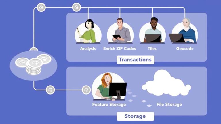
The number of ArcGIS Online credits that an organization uses is determined by its workflows. Yet many of the key ways in which organizations use ArcGIS Online do not consume credits. For example, no credits are consumed when using basemaps and imagery from ArcGIS Living Atlas of the World, creating and sharing maps and apps, managing data, or accessing public services. When an organization does use credits, they are consumed in two ways: through specific transaction-based workflows or by storing files, features, and imagery in ArcGIS Online.
Transactions
When members of an organization employ certain tools to perform spatial analysis, do geocoding, or use premium content from ArcGIS Living Atlas, that organization consumes credits. For example, using Plan Routes in Map Viewer to determine how a fleet of vehicles could visit a set of stops in the least amount of time would cost one credit per vehicle route.
Storage
The number of credits used for storage is determined by the size of the data stored in ArcGIS Online and the number of hours it is stored per month. The most common type of storage is feature storage, meaning data that is stored as a hosted feature layer, including points, lines, polygons, and standalone tables. The other type of storage that consumes credits is file storage, which is charged at a lower rate. This includes imagery layers; attachments; data packages for offline maps; and items that users add, such as PDFs, images, Microsoft Office documents, and service definition files (which contain information about service properties, capabilities, and the service type).

Here’s how many credits are used per capability.
Set Up Your Organization for Success
To help organizations make the most of their credits, several strategies are available to administrators:
- Administrators can enable credit budgeting for transactions to control how many credits members of their organization are able to use.
- With custom member roles, administrators can limit some members’ use of tools that consume credits.
- To help organization members understand their credit use, administrators can decide to show each member’s available credits on their settings page.
- Before organization members run an analysis tool, administrators can encourage them to use the Estimate credits option to get an approximation of the number of credits they will be charged for the workflow.
- By regularly running reports on items stored in their organization, administrators can assess the size of items and the date that they were last modified to determine whether they should be kept or deleted.
- Administrators can regularly run reports on credits to understand their organization’s usage.
Analyze Credit Use with Reports
It’s difficult to know how many credits an organization needs without having detailed information about credit usage. By generating a credit report, administrators and members with reporting privileges can download a CSV file with a comprehensive view of their organization’s credit usage by week, month, or quarter. Administrators can also schedule credit reports to help routinely monitor their organization’s credits.

Once a credit report is downloaded, administrators can see the number of credits consumed by transaction type for each member of the organization during the specified reporting window. The organization’s use of storage credits is also listed and split up by the type of storage, including feature, file, and imagery storage. It is recommended that organizations use a combination of credit reports and item reports to determine whether the items being stored are needed.
To create a report on credits, go to the Organization page in ArcGIS Online and select the Status tab. There, administrators will see options to make and schedule reports and view previously created ones.
Watch a video of how to create a credit report.
Create a Credit Plan
ArcGIS Online credits bring flexibility to organizations, allowing them to scale their usage as needed and pay only for what they use. By running reports on their organization’s credit usage, administrators can create a credit plan as unique as their workflows. For many organizations, reports could reveal that the standard number of credits included with their chosen user types is sufficient. For others, they may discover that they need to scale up and add credits to accommodate every user’s requirements.

