Gray’s Reef National Marine Sanctuary, a marine protected area off the coast of Georgia, is one of the largest nearshore live-bottom reefs in the southeastern United States. The sanctuary, managed by the National Oceanic and Atmospheric Administration’s (NOAA) Office of National Marine Sanctuaries, is composed of rocky ledges, undercuts, and sand patches that provide habitat for thousands of species of invertebrates, marine mammals, and fish. Fishing and diving are permitted in the sanctuary, giving anglers the chance to catch black sea bass, mackerel, snappers, and groupers.

To conserve the reef’s vast resources, an entire team conducts scientific research, provides education, and performs outreach to locals and visitors alike. In 2019, the team began an initiative to connect with fishers through learning exchanges and in-person educational workshops to teach them about Gray’s Reef and equip them with best practices.
But when the COVID-19 pandemic hit early the following year, the learning exchanges at Gray’s Reef had to shift from in person to virtual. To facilitate this, the team at Gray’s Reef collaborated with Esri partner Dewberry to develop an online solution that would live on the sanctuary’s website. Built using ArcGIS Experience Builder, the web app has improved how Gray’s Reef communicates with the fishing community and boosted cooperation among the project’s partners.
Replicating a Dynamic Experience
The learning exchanges were initially held along the Georgia coast. Made possible with National Marine Sanctuary Foundation funding, which environmental organization The Nature Conservancy (TNC) applied for and received, the exchanges sought to find out from community members what they wanted to learn about the sanctuary while equipping them with vital information and general education about it.
When such in-person gatherings ceased in 2020, the group working on them—which, in addition to Gray’s Reef and TNC, included the University of Georgia’s Marine Extension and Georgia Sea Grant, the South Atlantic Fishery Management Council, FishSmart, and the Georgia Department of Natural Resources—opted to create an online product on the Gray’s Reef website that people could access from anywhere, at any time.
“We wanted to make it…as interactive and dynamic of an experience as we could, but be safe,” explained Robert Crimian, southeast ocean conservation specialist for TNC. “The idea of this living on the website for years to come instead of being a stagnant, workshop-based project seemed appetizing.”
According to Stan Rogers, superintendent at Gray’s Reef National Marine Sanctuary, the initiative doesn’t simply explain fishing regulations to fishers; rather, it connects people through education and best practices and improves understanding of critical issues at the sanctuary.
“Gray’s Reef is…in federal waters. It belongs to all US residents. It’s yours; it’s mine; it’s ours,” Rogers said. “It’s our obligation to communicate these things to the people at large, not just specific user groups or people who live on the coast.”

The critical issues at Gray’s Reef include combating barotrauma—injuries that deepwater fish, like snappers and groupers, can get from being pulled to the surface too quickly and experiencing rapidly changing atmospheric pressure. Best practices encompass learning which hooks are best for catching certain fish and the maximum amount of time a fish can be out of water.
“Gray’s Reef has been an ideal fishing destination for 40 years, and it’s because of past generations conserving the fish [and] the habitat there that our children and grandchildren can, hopefully, fish at the levels that [people] did in the past,” said Ben Prueitt, outreach and social media coordinator at Gray’s Reef.
Creating an Immersive, Informative Site
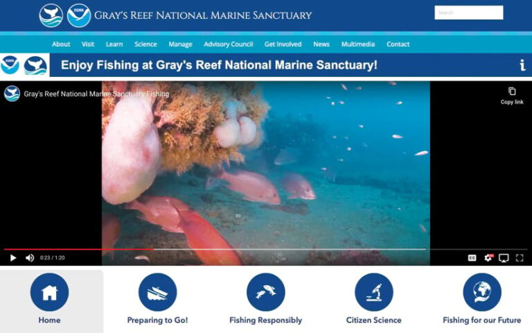
The team members at Gray’s Reef wanted the online site to be eye-catching, interactive, and dynamic. They wanted participants to be able to move at their own pace and click buttons to receive more information on specific topics. They also wanted to give visitors a view of Gray’s Reef under the surface so fishers could better understand the incredible resources that the rules and regulations are put in place to protect.
In addition, because previous analytics revealed that a large number of mobile phone users access the Gray’s Reef website, the team wanted their online solution to have responsive design and be optimized for mobile devices.
To build the site, Siddharth Pandey, geospatial technology manager with Dewberry, selected ArcGIS Experience Builder, which would allow the site experience to happen all in one space. The app builder enables users to create mapcentric (or nonmapcentric) apps without having to do an extensive amount of coding.
Pandey discussed the desired user experience with the team and considered things like what people need to know before getting to the reef, such as important regulations. He then read some documentation to learn how to use Experience Builder, but he mostly did a lot of trial and error to get the look and experience right.
“It was fun,” Pandey said. “There’s a fairly steep learning curve, but…once you get past that, then it’s really easy to use.”
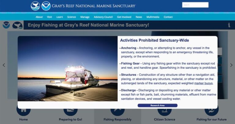
There was a significant focus on making the site accessible and simple, so Pandey included pop-up windows with additional information. Alternative text was also added to images to help individuals who use assistive devices. The app is hosted on NOAA’s GeoPlatform—which provides geospatial data, maps, and analytics to the public—but Gray’s Reef team members have direct access to it and can edit and adjust the experience based on user feedback.

“It was really about making it as immersive as it is easy to use,” Pandey said. “You can look at different buttons and get a sense of exactly what you’re going to experience when you click on [one] and go to that [page].”
The final site includes several pages. The main page showcases an introductory video on the purpose of the site and why the information is important. Another section, on preparing to go to Gray’s Reef, displays information on the reef’s habitats via an ArcGIS StoryMaps narrative. It also includes videos of some of the animals that live on the reef, like black sea bass and a school of ladyfish. Another section details the regulations of the sanctuary and the reef’s research area. Additionally, there are sections focused on community science, such as how to participate in a catch-and-release program for shallow-water fish, and the future of fishing at Gray’s Reef.
Reaching a Broader Segment of Society
The new Gray’s Reef best fishing practices experience launched in November 2021, and the results have been outstanding. It became one of the top 10 experiences on the sanctuary’s website, and it was the one that visitors spent the most time on.
According to Crimian, anglers are enjoying the new site and were major contributors to the content, which they see reflected in the experience. Additionally, the site has allowed the Gray’s Reef team to reach a larger portion of recreational fishers, said Elliott Lam, state program manager at Gray’s Reef National Marine Sanctuary.
“When we go out to talk with local [fishers], we end up talking with the ones that are living at the coast, where we are, but not necessarily encompassing all the ones that travel down…from other parts of the state or the region,” Lam said. “By having access to this year-round, at their convenience, they get to have the same content of a new fisher orientation as they would get from one of our in-person meetings.”
The visual components of the experience are exciting for Rogers, who believes the team can reach more people with multimedia elements, such as 360-degree videos of the reef, slideshows, and maps. Despite having to curtail in-person events for a while, the website has been a great way to enhance engagement with the public.
“It’s our obligation to make sure we are reaching a broad segment of society…and that we are speaking in a language that the general public understands,” Rogers said. “Products like these are more engaging…so it’s going to hit a broader community.”

Having all the different sections housed in one site has improved information gathering as well. Because each of the partners on the project has its own website, it helps that the site built with Experience Builder can bring all that information together in one place. This makes it easier for users to absorb content while also providing an interactive experience, according to Prueitt.
Pandey enjoyed using Experience Builder as well. Once he had created a custom template with the app builder, he was able to customize and expand on it. Staff members at Gray’s Reef can also now update the site, even if they don’t have any experience with coding. This means that Gray’s Reef no longer has to hire specialists to do this.
“Should the team [members] decide they want to add pieces to it or construct something similar, it’s a template. You just kind of continue to add more sections or buttons to modify things,” said Pandey. “A lot of that work doesn’t need to be redone, which is really nice.”
Looking Forward to More Collaboration
The Gray’s Reef team has already built a similar scuba diving site with Experience Builder and looks forward to using the tool to create additional resources for visitors. Rogers said that other sanctuaries are interested in creating similar sites as well, so the team hopes for more opportunities to collaborate with other groups.
“That’s where the strength is in [Experience Builder],” he said. “It’s not coming from one voice. It’s coming from a collection of information from various partners. And that really builds trust and believability into these things when you see it coming from multiple sources.”
Rogers also believes that this is only the beginning of efforts at Gray’s Reef to use apps like this to reach people.
“I can imagine that more dynamic content—like this site built with Experience Builder—is going to receive a lot more visitation and longer exploration of our web content,” he said.

