The Arctic is warming up to four times faster than the rest of the planet. This polar region is not only a canary in the coal mine, but it is a climate accelerator that won’t be stopped until humanity puts the brakes on fossil fuel emissions.
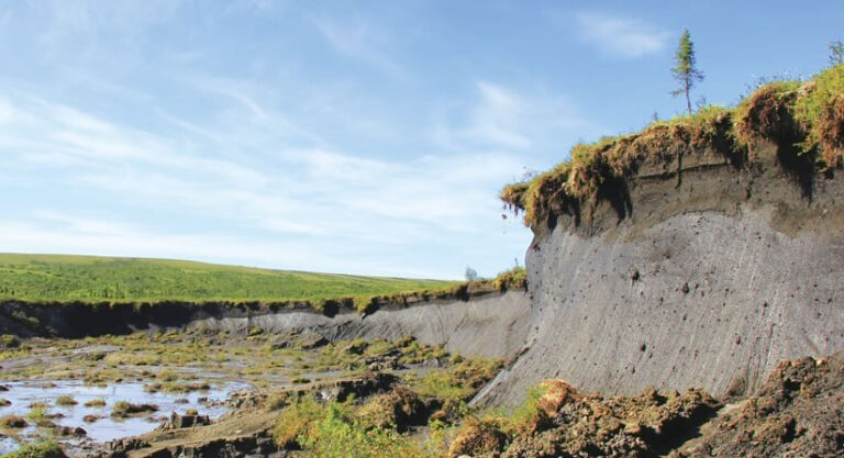
Melting glaciers and ice sheets are contributing to global sea level rise, and temperatures in the north are changing weather patterns across the planet and amplifying droughts, heat waves, and hurricanes. Perhaps less observable to the rest of the world, however, is the thawing of permafrost—permanently frozen ground—that underlies much of the Arctic. Arctic peoples and ecosystems are already grappling with the devastating effects of permafrost thaw, and the consequences extend beyond the northern latitudes.
Yet unlike with sea ice and glaciers, where long-term satellite observations have tracked melt rates for decades, long-term geospatial records of permafrost thaw do not exist. Scientists and Indigenous Knowledge holders have been observing permafrost thaw for decades, but assessing the full scope of these changes—which occur at relatively small spatial scales across a vast and varied region—has been a technical challenge.
Permafrost Pathways is working to map and monitor these important changes. Catalyzed with funding through The Audacious Project, housed at TED, this initiative brings together scientists, Arctic communities, Indigenous Knowledge holders, and experts in environmental justice and climate policy to improve permafrost science. Their goal is to inform and develop adaptation and mitigation strategies to address the hazards caused by permafrost thaw.
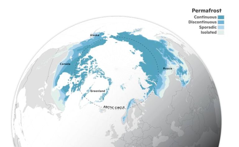
Using satellite imagery and AI, the team is mapping permafrost and greenhouse gas emissions across the Arctic for the first time to better inform climate models. To convey what is happening and what to do about it—both with and beyond the scientific community—the initiative has made map-based storytelling a key communication strategy.
The Importance of Permafrost
In the Northern Hemisphere, permafrost underlies more than 5.4 million square miles (14 million square kilometers)—an area that is larger than the United States and the European Union combined. It underlies 15 percent of exposed land surface, including much of Alaska, Canada, and Russia.
This permafrost region is critically important for global climate because it stores a disproportionate amount of carbon that has been frozen for thousands of years. As the climate continues to warm, that once-frozen carbon can be decomposed by microbes and released into the atmosphere as greenhouse gases, carbon dioxide (CO2) and methane (CH4). Those emissions contribute to future warming, leading to more thaw. By the end of this century, the amount of permafrost carbon that will be released into the atmosphere is expected to be comparable to that of major greenhouse gas emitting nations—perhaps even as large as current emissions from the United States.
The greenhouse gas emissions caused by permafrost thaw are not fully accounted for in global climate models. Thus, humanity’s efforts to curb global warming will be even harder to achieve. Emissions from thawing permafrost could use up to about 25 percent of the remaining carbon budget that would be necessary to cap warming at the internationally agreed-upon 2 degrees Celsius threshold established in the 2016 Paris Agreement.
As permafrost thaws, melting ground ice can cause catastrophic changes to Arctic lands, including sinking and collapsing ground, accelerated coastal and riverine erosion, the draining of lakes and other surface water, and changing distributions in vegetation and wildlife. These cascading effects are already transforming tundra and boreal regions, forcing Indigenous communities in the Arctic to make extremely difficult decisions to protect themselves and their traditional ways of life. The dramatic environmental changes brought about by permafrost thaw impact Arctic infrastructure, access to clean water and other public utilities, subsistence hunting and fishing, food sovereignty, and community health and wellness. In Alaska, more than 144 communities face imminent displacement and other threats from permafrost thaw, flooding, or erosion.
Mapping Thaw and Scaling Its Effects
With so many extreme transformations unfolding across the Arctic, there is an immediate need to better assess current and future rates of permafrost thaw and their impacts, from local to global.
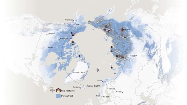
The team at Permafrost Pathways is harnessing high-resolution satellite imagery and AI and using ArcGIS Pro and the Esri World Imagery basemap to identify, digitize, and map places where thawing permafrost causes rapid ground collapse. These “abrupt thaw” features, which have never been mapped across the entire Arctic, are extremely important because the greenhouse gases released from them will cause additional climate warming—possibly double what is currently expected from gradual thaw alone.
Having geospatial data on thaw features is important not only for mapping them but also for scaling site-level observations of the greenhouse gas exchange that happens between permafrost lands and the atmosphere. At some monitoring sites underlain by permafrost, scientists have already begun to observe the net release of CO2 and CH4 into the atmosphere. This represents a major shift in the functioning of ecosystems that had historically been carbon sinks—meaning, they had taken carbon from the atmosphere—for thousands of years.
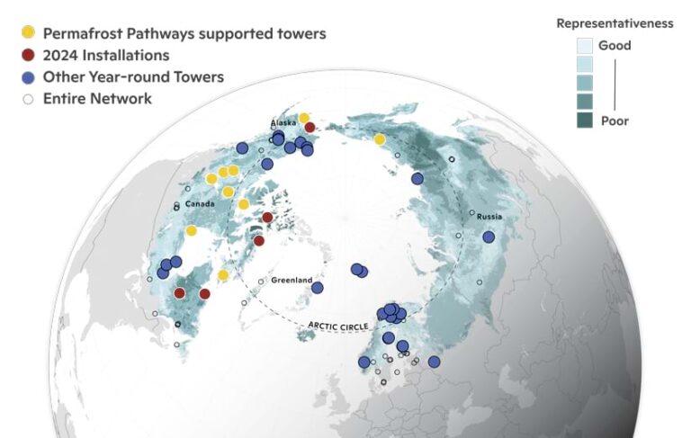
Such site-level observations are essential for gaining a new understanding of processes and changes in system indicators. Yet there are still major scientific uncertainties about how these dynamics function across the entire permafrost region. To fill this gap, Permafrost Pathways is strategically installing new greenhouse gas monitoring sites across the Arctic and using the data that they record to scale greenhouse gas emission estimates for the region.
Sharing Information Through Stories
While advancing Arctic carbon cycling science is crucial for addressing the global effects of permafrost thaw, information needs to be shared beyond the scientific community to inform climate mitigation and adaptation priorities.
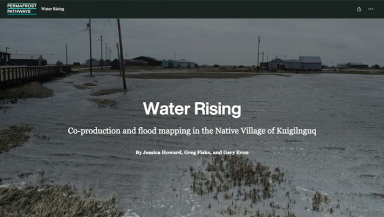
At a recent Arctic mapping workshop held at Esri’s headquarters in Redlands, California, Western-trained scientists, technical experts, and Indigenous Knowledge holders came together to use ArcGIS technology to tell stories about the impacts that climate change is having in the Arctic, support adaptation decision-making, and track the global effects of permafrost thaw. Staff from Esri and Permafrost Pathways shared how they are integrating AI and geospatial data to map permafrost thaw features across the Arctic and discussed using drone technology to map erosion, flooding, permafrost thaw, and storm impacts. Tribal partners and other participants used ArcGIS StoryMaps to create stories that emphasize the rapid changes occurring in their communities and worked on making new maps with Indigenous place-names on them that will help preserve and share traditional language, knowledge, and culture across generations.
Arctic Indigenous communities have been living with and adapting to climate change for decades. But the rapid escalation of these transformations requires a coordinated effort that brings together multiple knowledge systems to monitor and map the changes and any associated growing risks. Such an effort will help guide adaptation strategies, meet global emission-reduction goals, and support community resilience.
To make this vision a reality, solutions must include an improved understanding of thawing permafrost, take a human rights-based approach, and be designed and implemented with Arctic communities at the helm. The progress we make today and over the next several years can make all the difference in securing a safer Arctic future for all.
