Picture a world where the hidden becomes visible and our planet’s unseen layers are revealed in a new light. This is the world that scientists began to explore in the mid-20th century, transcending human vision to uncover Earth’s secret patterns and phenomena. From physicists to agricultural scientists, these pioneers ventured into the realm of new wavelengths, opening a window to a previously invisible world. Their quest for deeper understanding of landscape features led to the Landsat satellite program, an initiative that transformed our view of Earth from space.

The Multispectral Imagery Revolution
Multispectral imaging, a key tool for the Landsat program, marked a leap in how we observe our planet. It captures data in wavelengths that are beyond the narrow band of light that humans can see, revealing aspects and details of the earth’s surface that are not observable in true-color photographs. This can provide unique perspectives for different features such as vegetation, soil, and water.
“With multispectral data, we can see the glow of photosynthetic activity of vegetation in the Amazon rainforest, examine crop health in southeast Asia agricultural areas, explore wildfire scars in Africa, and measure the retreat of Arctic glaciers,” said Kate Fickas, Esri’s director of imagery and remote sensing solutions.
The Landsat satellites and their multispectral sensors have become key observers of our planet. Since its first satellite launched in 1972, Landsat has recorded the earth’s surface, creating a legacy of data. More than five decades later and with the 2021 launch of the Landsat 9 Earth observation satellite, Landsat is more than just a satellite program—it’s a storyteller, a record keeper, and a guide to understanding our rapidly changing world. Jointly managed by the US Geological Survey and the National Aeronautics and Space Administration, Landsat’s longevity and consistency have made it the gold standard in optical imagery and remote sensing.
Unlocking Global Imagery for Everyone
Historically, the Landsat program has presented a few challenges. The first is the sheer volume of data, collected for more than 50 years. The second is the complexity of the spectral data. Despite advances in imagery and remote sensing data accessibility in the past decade, these challenges remain, especially for those who are unfamiliar with this type of data or who want a quick and easy way to explore Landsat resources.
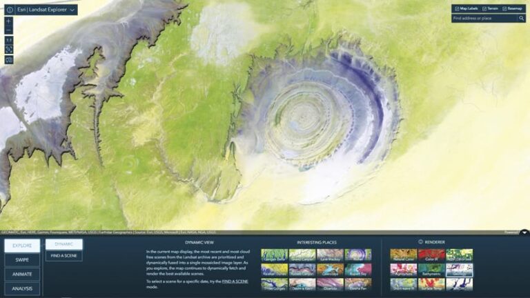
To increase Landsat data accessibility, Esri developed the Landsat Explorer app in ArcGIS Living Atlas of the World. It enables users, regardless of expertise, to easily explore Landsat data. From urban expansion to the shrinking of lakes, the app makes the complex world of Landsat data accessible and captivating.

ArcGIS Living Atlas is now an entry point for exploring Landsat data. More than just a collection of maps and data, it’s a dynamic gateway to accessible and empowering geospatial insights. This digital atlas holds a diverse range of data layers, maps, and apps, enabling users to better understand the world through GIS. According to Fickas, “It’s an evolving resource that simplifies the discovery and application of geographic information—something that’s critical in a time when geographic insights are needed for informed decision-making.”
Landsat Level-2 data from as early as 1982 is a dynamic time series of imagery available across the ArcGIS system and used to power Landsat Explorer. With an intuitive user experience, the app leverages ArcGIS capabilities to unlock and explore a wealth of Landsat information.
This integration of traditional GIS with Landsat imagery offers a rich and dynamic understanding of our planet and location intelligence. GIS provides precise spatial information while imagery adds contextual depth, providing a holistic view that is greater than the sum of its parts. For GIS beginners and experts alike, Landsat Explorer can spark curiosity and provide comprehensive answers to complex spatial questions.

