Property and land surveys are crucial resources for anyone who plans to purchase or develop property. Surveys, parcel maps, and subdivision maps can all be used to determine the boundaries of a piece of property, which can be critical should a land dispute arise.
Construction and engineering companies that use survey and land records daily understand the financial and legal advantages of obtaining a property survey and doing some historical research before buying land. But since neither of these is required by law, many home buyers and title companies skip this essential step prior to closing on a property deal. One of the main reasons is because it is not easy to access previously recorded surveys and information about property.
But the County of San Diego is changing that. Working with Esri partner PTFS (Progressive Technology Federal System), the Southern California county developed and deployed a new, web-based cloud solution to manage all its survey records and map documents—and make them easier for the general public to find.

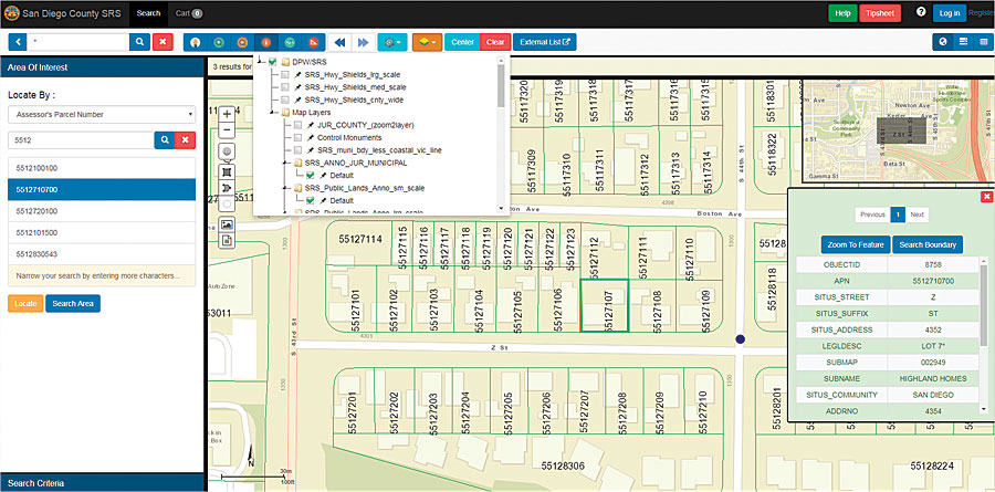
The browser-based Survey Records System (SRS), which replaces a slower, antiquated system, integrates ArcGIS Desktop and PTFS’s Knowvation GS content management system (CMS). The app allows users to find land documents by searching geospatially, via full text, or through a combination of both. To search something geospatially, users draw a box or polygon around an area of interest on the map. For full-text search, users can have the SRS scour every word of every document—including the metadata—to find the specific surveys they are looking for. A combination of the two search functions allows users to really refine the parameters to quickly and easily track down the documents they need.
While the primary users of the SRS are members of the public who need to identify property lines, the system also contains topographic maps, floodplain maps, maps that detail subdivision road improvements, and many other map documents that can provide internal users at the County of San Diego with useful information about public and private property in the area.
The document side of the SRS is powered by PTFS’s geospatial CMS, Knowvation GS. As a browser-based, full-text search and retrieval system for digital libraries and repositories, Knowvation GS allows organizations to more easily manage digital data collections. And when paired with the mapping and layer capabilities of ArcGIS, it makes it easy to find the right surveys for the right parcels of land.
The public can openly search and view the county’s land documents for free. But because the County of San Diego charges small fees for procuring property information (mainly to cover administrative costs), downloading watermark-free materials involves a few extra steps. For example, if a home buyer’s lender requires a property survey, the prospective property owner would go to the county’s SRS, find the survey for the property under consideration, add it to the shopping cart, pay for the download via PayPal, and send it to the lender. This integrated process takes just minutes, and if the correct documents are in the SRS, there is no need for the home buyer to obtain a new survey.
Since having a cloud-hosted solution was a primary goal for the County of San Diego, integrating Knowvation GS with ArcGIS was the most critical step in the development process. To make it possible for users to search the documents by location on the SRS’s basemap, developers used ArcGIS Desktop to georeference the existing survey data and converted the original TIFF files into GeoTIFFs. Surveyors for the County of San Diego now import these GeoTIFFs into Knowvation GS, which links the documents to ArcGIS Server and ties the survey records to map coordinates. From there, users can type in an address, a parcel number, or coordinates to search and retrieve documents in the app, using its intuitive graphical user interface (GUI).
In addition to creating such comprehensive search, discovery, and dissemination capabilities, PTFS helped the County of San Diego migrate its entire collection of land and survey records to a secure cloud environment. This makes the SRS more flexible, faster, and easier to use across all browsers.
“Many of our customers have commented about the helpfulness of these seemingly simple improvements over the previous system,” said Scott Redlin, a GIS analyst from the County of San Diego who worked on the project. “Since the Survey Records System went live, use of the SRS has so far been successful, with a number of users commenting on how they appreciated the higher speeds and the new Esri GUI features that were not available in the old system.”
Building on all the positive feedback, the County of San Diego expects to see expanded use of the app.
About the Author
Quinn Hazelton is a senior account executive at PTFS. For more information about the County of San Diego’s new SRS, email him at qhazelton@ptfs.com.

