ArcGIS Indoors and ArcGIS IPS are Esri’s flagship indoor mapping and positioning products that enable organizations to gain geospatial context of their interior spaces. Indoor GIS can help manage indoor assets like broken pipes and desks; evaluate space usage trends by displaying foot traffic patterns, social distancing metrics, and cleaning statistics; and provide routing to get people to where they need to go or even evacuate building occupants safely during an emergency.
New this year, ArcGIS Indoors is available in three different options: ArcGIS Indoors Pro, ArcGIS Indoors Maps, and ArcGIS Indoors Spaces. This makes it easier for organizations to extend their existing ArcGIS systems to address their indoor needs. ArcGIS Indoors Pro and ArcGIS Indoors Maps enable users to transform computer-aided design (CAD) and building information modeling (BIM) floor plans into floor-aware maps that can be used for indoor mapping and wayfinding. ArcGIS Indoors Spaces allows people to produce maps and apps that can be used for space management and work space reservations. Additionally, both ArcGIS Indoors Maps and ArcGIS Indoors Spaces can be enhanced with ArcGIS IPS, which provides real-time indoor positioning and tracking.

Read on to get a more detailed look at how these products work.
Three Options and a New Experience for Indoor Mapping
ArcGIS Indoors Pro extends the capabilities of ArcGIS Pro to build floor-aware indoor maps, supporting the creation of an indoor digital twin. Indoors Pro transforms CAD and BIM floor plan data into an indoor system of record—a single, accessible place that can be used to support asset mapping, safety, security, and event planning. Indoor maps built in Indoors Pro can be further used in wayfinding and space management workflows that are supported by two other products in the ArcGIS Indoors product suite, ArcGIS Indoors Maps and ArcGIS Indoors Spaces.
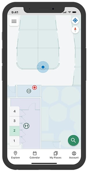
ArcGIS Indoors Maps delivers location-based experiences, such as wayfinding and incident reporting, to everyone in an organization. Building occupants and visitors can use the Indoor Viewer, kiosk mode, and the Indoors mobile app to easily locate and navigate around an organization’s buildings. When there is a problem in a building, such as broken equipment or damaged property, Indoors Maps can help staff members from IT and facilities locate the issue quickly. If ArcGIS IPS is added to Indoors Maps, users can see their real-time location represented by a blue dot while wayfinding.
ArcGIS Indoors Spaces equips organizations with space management capabilities and allows employees to make work space reservations—a necessity in this new era of hybrid workplaces. The Indoor Space Planner app that can be added to Indoors Maps enables users to define, allocate, and assign space within buildings, which can help coordinate staff moves, honor social distancing requirements, support a safe return to work, and maximize space usage. It offers a simple and straightforward way to foster a productive and collaborative workplace while giving employees the flexibility to work in the spaces that best suit their needs.
ArcGIS IPS is an indoor positioning system that adds a live location experience to maps created with ArcGIS Indoors and custom-built apps based on ArcGIS Runtime SDKs. With ArcGIS IPS enabled, users can see their real-time location inside a building represented by a blue dot. This increases location awareness by showing users where places, people, and points of interest are relative to their position. ArcGIS IPS also provides options for location sharing and tracking (when users opt in), location data capture, and analytics. This can help building occupants and managers alike make better-informed decisions not only about where to go but also about space management and resource allocation issues.
Get Started with Better Indoor Mapping
Now more than ever, business leaders need the geographic context that only GIS can provide to understand patterns and relationships—indoors. ArcGIS Indoors and ArcGIS IPS give organizations the tools they need to use GIS inside their buildings and enable supervisors, employees, contractors, and visitors to better navigate and manage the indoor spaces they’re in.
To get started with an indoor GIS deployment, visit the ArcGIS Indoors product page and the ArcGIS IPS product page to reach out to an Esri representative.

