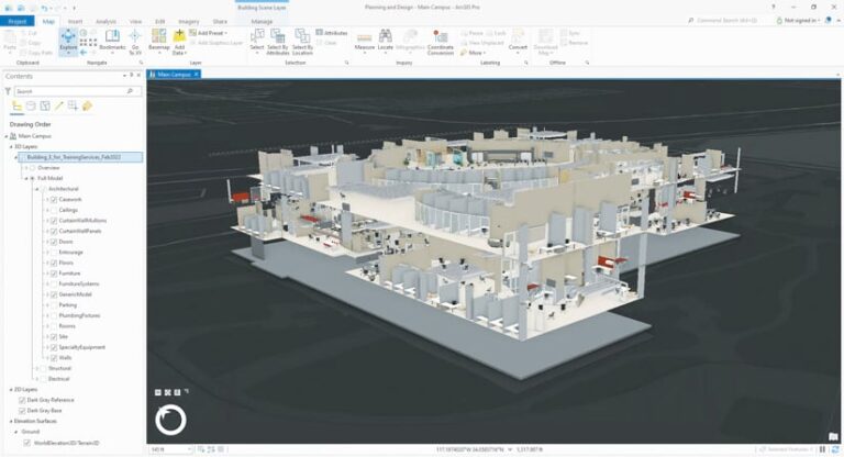
After years of separation—that is, using separate systems and disconnected workflows—many GIS and architecture, engineering, and construction (AEC) professionals are now integrating GIS capabilities, computer-aided design (CAD) data, and building information models (BIM) into holistic workflows that provide detailed understanding of a project’s design, assets, and geographic environment. They use this understanding to inform decision-making and enhance the entire AEC project life cycle, from planning and design to construction and ongoing operations.
To help people keep pace with this growing interconnectedness, Esri is releasing a new massive open online course (MOOC) called Transform AEC Projects with GIS and BIM. Running September 14 through October 12, the course will give participants firsthand experience with integrating CAD, BIM, and GIS data to help reduce costs, streamline workflows, and increase sustainability throughout a project’s life span.

Applying Geographic Context to Construction Projects
GIS data has been used for a long time in the planning and operation of buildings, bridges, airports, and other infrastructure projects—and CAD and BIM data is key for the design and construction of those structures. Bringing all this data together offers many benefits.
“Understanding the geographic context of a project allows architects and planners to optimize the design based on site topography and nearby natural and built features,” said Rafael Lucero, practice lead for AEC and indoor GIS at Esri. “The cost of making design changes after materials have been ordered or construction has started is significant. And the larger the project, the higher the cost. One seemingly minor change can have a ripple effect, requiring larger changes that could dramatically increase the total project cost.”
ArcGIS Pro analysis tools are valuable in the design phase of a project to calculate viewsheds, shadow patterns, and the potential impact of a new structure on nearby environmental features, such as wildlife corridors and public green spaces. These location-based insights enable architects and engineers to adjust the design prior to construction if needed.
“Using ArcGIS Pro, architects and engineers can overlay CAD, BIM, and GIS data on a map and output highly realistic project visualizations,” Lucero explained. “These visualizations can be shared to an accessible, cloud-based location during the design phase. This allows stakeholder feedback to be efficiently collected, evaluated, and incorporated into the design.”
During construction, drone-captured imagery is frequently used to monitor jobsite progress. Using Site Scan for ArcGIS and ArcGIS Drone2Map, AEC project managers can visualize each stage of construction and quickly share updates using a dashboard. In Esri’s new MOOC, attendees will learn how to create a 3D mesh using Drone2Map and ArcGIS Pro, upload the mesh to ArcGIS Online, and use dashboards to share project updates.
A Weekly Sampler of Modern AEC Workflows
Since Esri launched its MOOC program in 2014, more than 150,000 participants from around the world have taken courses on imagery, cartography, spatial data science, and other topics of interest to GIS professionals and lifelong learners of all persuasions.
Transform AEC Projects with GIS and BIM is the eighth MOOC that Esri has developed and offered at no cost to people around the world. Each week, attendees will get access to one or more videos featuring Esri experts, complete a step-by-step exercise using provided ArcGIS software, and visit discussion forums to ask questions and interact with other participants and Esri staff. While attendees are welcome to complete all the course content at their own pace, those who wish to earn a certificate of completion should plan to start each section during its opening week to stay on track.
This course is most relevant to practicing or aspiring architects, landscape architects, civil engineers, planners, construction professionals, GIS professionals, and others who work on private or public sector construction and infrastructure projects. That said, anyone who enjoys exploring GIS technology topics is invited to attend. Familiarity with GIS and ArcGIS Pro will be helpful but is not required.

