Once per decade, the United States Census Bureau sets out to count every person in the country, just once, and in the right place. The bureau spent 10 years preparing for the 2020 Census by modernizing its systems and building apps. It has successfully replaced paper-based processes with new technologies that have significantly improved data collection and workflows.
Throughout its preparation for the decennial event, the Census Bureau collaborated with Esri, weaving geospatial capabilities into every operational component. The bureau was ready to do the count, but unforeseen challenges lay ahead.
By Census Day on April 1, 2020, most households in the United States had received their invitation to participate in the census. Unfortunately, by this time the first wave of COVID-19 had swept across the nation. While wreaking havoc on public and personal health all over the world, COVID-19 also impacted 2020 Census operations.
The pandemic stalled the launch of the bureau’s nonresponse follow-up (NRFU) operations, in which enumerators visit the addresses of people who did not respond to invitations. Initially, the Census Bureau scheduled NRFU operations to begin May 13, but the risk of infection delayed the launch. On July 16, the bureau resumed follow-up operations in select areas.
When it was deemed safe, thousands of masked enumerators, equipped with iPhones, began knocking on doors. From a safe distance, they asked residents census questions and recorded their answers digitally on their phones. The bureau continued to monitor the impacts of COVID-19 on operations and adapted assignments as needed to keep everyone safe.
“The modernizations that we put into place far exceeded our expectations,” explained Deirdre Dalpiaz Bishop, chief of the Census Bureau’s Geography Division. “Geographic information and associated technologies played a role in the transformation of the four main components of conducting the census.”
Those components for the 2020 Census are
- Establishing where to count.
- Motivating people to respond.
- Counting the population.
- Tabulating and disseminating the results.
Since each component is geography based, the Census Bureau deployed GIS apps, which used Esri technology, to streamline every aspect of the count. That made a huge difference in this strange and atypical time.
Validating Addresses—Mostly Digitally
Well before census operations begin, the Census Bureau updates a national address list. An accurate address list is fundamental to the operational success of the census count. It is essential for mailing invitations and for follow-up efforts. By employing satellite imagery and GIS—and having people walk around certain hard-to identify areas to verify addresses—staff members built a highly accurate list for the 2020 Census.
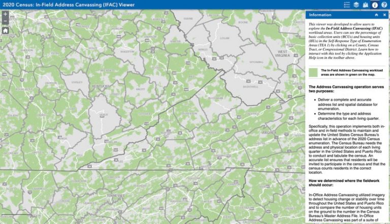
Using the Block Assessment, Research and Classification Application (BARCA), which was developed with ArcGIS API for JavaScript and leveraged map and imagery services served in ArcGIS Enterprise, 150 staff members reviewed 11.1 million census blocks. While working in the office, they were able to validate 65 percent of the nation’s addresses.

The validated areas were displayed on a map viewer, as were areas that required in-field validation. The Census Bureau shared the map viewer with the public to help people understand which areas census employees would be visiting.
“In 2010, address validation operations involved 150,000 participants, but 10 years later, modernizations—including geospatial technology—enabled us to reduce our address validation workforce to 32,000,” noted Bishop.
States use the decennial census to define congressional districts, state legislative districts, and voting districts, so those boundaries must align with census block boundaries. The Census Bureau’s Geographic Area Reconciliation Program (GARP) manages this—the bureau’s largest geospatial quality control effort. GARP brings together and reconciles data from many geographic operations, such as a statistical areas program, voting operations, and ZIP code operations. The bureau also developed an operational dashboard to manage GARP processes to ensure that 14.1 million unique geographic borders aligned.
“Without the dashboard, we may not have successfully completed the process according to schedule,” said Bishop.

New Techniques to Encourage People to Respond
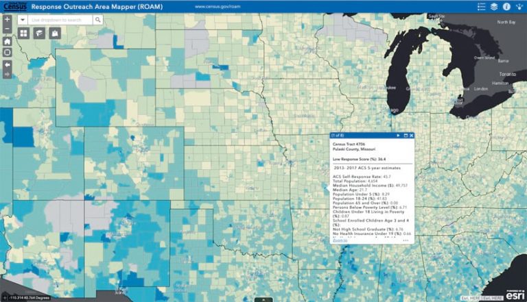
Getting people to self-respond to the census reaps the greatest results. The Response Outreach Area Mapper (ROAM) app, built with Esri software, streamlined this process.
Using data from the Census Bureau’s American Community Survey and the 2010 Census, the bureau modeled areas that were likely to have low self-response rates. The results were displayed on a color-coded range map, so community groups knew where best to target education resources and outreach. Although COVID-19 made it difficult to do community outreach at the levels that the bureau had hoped for, ROAM performed well and will be used to help manage outreach during the Census Bureau’s ongoing survey work.
Making a Massive Follow-Up Operation More Efficient
During the peak of its follow-up operations, the Census Bureau had nearly 240,000 enumerators collecting information. To manage this massive undertaking, the bureau used its Field Operational Control System (FOCS), which securely employed vector tile and dynamic map services hosted in ArcGIS Enterprise, to plan out the workload. Managers used FOCS to assign enumerators to certain geographic locations.
FOCS maps also let managers see where operations were on track and where they needed to boost the number of resources. They could use the system’s proximity function as well to ensure that enumerators got assignments that were close to their homes.
In addition, the bureau employed ArcGIS Network Analyst and ArcGIS StreetMap Premium to help optimize the workload for NRFU operations and send enumerators on the most efficient routes possible.
“We have a very strong working relationship with Esri,” said Bishop. “We’re continuously collaborating as we enhance the tools we use to get our job done.”
Delivering Results
The final task for the Census Bureau is to ensure that all responses are associated with their correct geographic locations in the National Address List. The bureau is (as of press time) working to complete this task and fulfill its mission to count every person, just once, and in the right place.

