National Council on Crime and Delinquency Partners with 54 California Counties
Human services agencies are responsible for the safety and welfare of clients under their care. Child welfare agencies protect the safety and welfare of children in foster care. Agencies providing supportive services to the elderly must safeguard their clients’ well-being. A given California county may be responsible for thousands of children and adults in homes and facilities spread out over a large geographic area.
When emergencies or natural disasters strike—flooding, fires, and industrial accidents, among other examples—these agencies must quickly communicate with their facilities to keep their clients safe. In California, where wildfires and earthquakes are unfortunately common, this can occur several times a year.

In the past, agencies accomplished this by comparing the map of the emergency-affected area with lists of facilities, sorted by ZIP code—a time-consuming and often imprecise solution. Tony Muga, a child welfare data analyst in San Bernardino County, notes, “Some of these ZIP codes are so large that we couldn’t tell right away which addresses corresponded to an area that was immediately threatened by a fire. So we ended up calling people who were not in any danger at all.”
San Bernardino County is one of 54 California counties that partner with the National Council on Crime and Delinquency (NCCD) for child welfare data monitoring and analysis through an NCCD service called SafeMeasures. SafeMeasures uses near real-time data to help child welfare agencies in California prioritize work and identify potential gaps in services before they lead to negative outcomes.
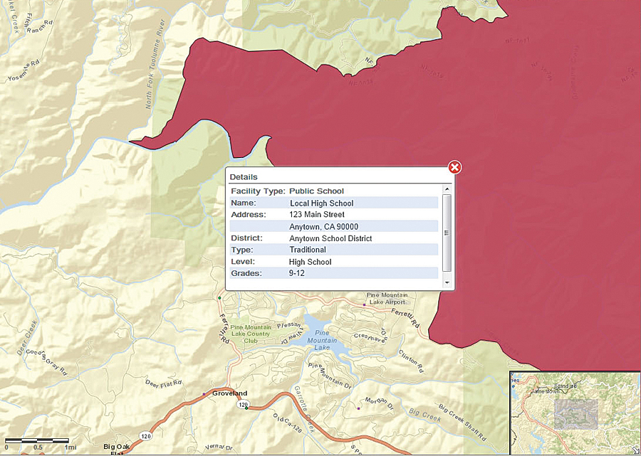
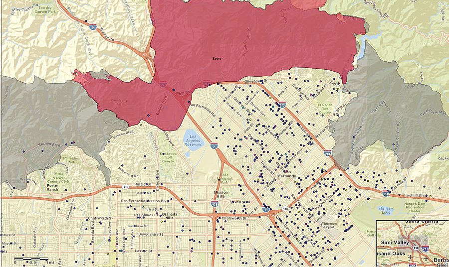
In 2006, NCCD added mapping to SafeMeasures, geocoding the addresses of all clients and foster homes in the process. NCCD identified sources of GIS data—such as the National Oceanic and Atmospheric Administration, the United States Geological Survey, and the California Department of Forestry and Fire Protection (CAL FIRE)—that could provide up-to-date information about the location and extent of wildfires, earthquakes, and other disaster situations. Layering client and event information together on a single map created a consolidated source of impact information that made it possible for NCCD’s client child welfare agencies to discard the manual process they had previously used.
In 2013, NCCD moved to Esri GIS products to improve SafeMeasures mapping. For geocoding, NCCD chose StreetMap Premium for ArcGIS because of its accuracy and coverage, both of which are critical to ensuring that a human services agency reaches all clients potentially affected by a disaster.

NCCD works with client, foster home, care facility, and other addresses from multiple states. Because of the confidential nature of this data, NCCD needed to develop a custom, in-house geocoding solution. On a typical day, NCCD geocodes 5,000 to 6,000 addresses. Some days, it geocodes more than 100,000 addresses. ArcObjects, in conjunction with StreetMap Premium data, provides a high-speed, low-cost, automated solution that handles this load quickly and accurately.
ArcGIS API for JavaScript provides the clean, easy-to-understand user interface that NCCD wanted for its clients. Standout features included better basemap imagery than NCCD’s prior tools—less cluttered at higher scales and more consistent in how it displays landmarks. NCCD uses custom and open-source code to access, organize, and render data for display, using standards like Web Map Service (WMS) to integrate this data into the map.
With the improved SafeMeasures maps, California child welfare agencies have an agile, streamlined process with which to keep clients safe in the face of an unfolding emergency. As Luis Fernandez, a data supervisor in San Diego County, explains, “Now we can see exactly where the kids are, and the map shows where the disasters are, so it’s simplified it quite a bit.” In the event of a fire, Fernandez states, “We go to that map, see where the fire is, and see the dots of placements near it. We can use that map to contact those foster homes.”
In a stringent fiscal climate, the GIS mapping approach reaps multiple benefits. Fernandez notes that in the past, data requests and regular reports were put aside when agency personnel had to find clients affected by an emergency. “Now, it takes only 15 percent of the time it took before because we don’t have to cast as wide a net.”
Other human services agencies are also beginning to use mapping. The Community Care Licensing Division of the California Department of Social Services is responsible for licensing nearly 67,000 facilities serving about 1.4 million California residents. These facilities include child care facilities, foster family homes, children’s residential group homes, and nonmedical out-of-home options for adults.
The advent of mapping “has been met with enormous appreciation,” says Central Operations Branch chief Kathi Mowers-Moore. “It’s huge for us and for our constituents.”
For more information, contact Timothy J. Connell, PhD, director of Application Development, NCCD.

