Around the world, the COVID-19 pandemic caught most organizations off guard as it suddenly—and enduringly—upended work culture. For businesses that can support their employees working from home, a remote workforce has become the new normal. But bringing employees back into the workplace is a big challenge—one that employers must prepare for now if they haven’t started doing so already.
Indoor spaces, as we came to find out, pose a greater risk of spreading COVID-19 than the outdoors. So hospitals, manufacturing facilities, retail businesses, logistics facilities, and other organizations that either could not let their employees work from home or brought their employees back early on needed effective ways to implement safety measures fast. Now, other businesses that are planning to reopen require the same measures. Even organizations that are offering an ongoing hybrid model, wherein employees work from the office sometimes and home the rest of the time, need to visualize things like how to more efficiently use their real estate.
Fortunately, ArcGIS Indoors, Esri’s indoor mapping and location tracking software, is uniquely suited to help with all this.
Redesigning Communal Spaces

When news of the rapid spread of COVID-19 first started making waves in March 2020, Esri’s facility mapping software, which leverages Indoors, enabled employers to use indoor spatial data to better understand their facility operations, steer staff members toward useful resources, apply contact tracing, and comply with safety measures to combat contagion. But a large part of the workforce went remote anyway, with more than 42 percent of employees in the United States alone working from home full-time as of the end of June, according to a study out of Stanford University.
Since the initial outbreak, however, cities, counties, states, and countries around the world have entered various stages of recovery, compelling organizations to look at what it would take to bring their workforces back. The priority is to create a safe communal working environment that employees feel comfortable returning to, which entails honoring social distancing requirements by reducing indoor capacity and regularly sanitizing frequently touched areas.

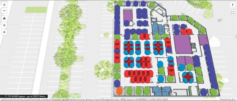
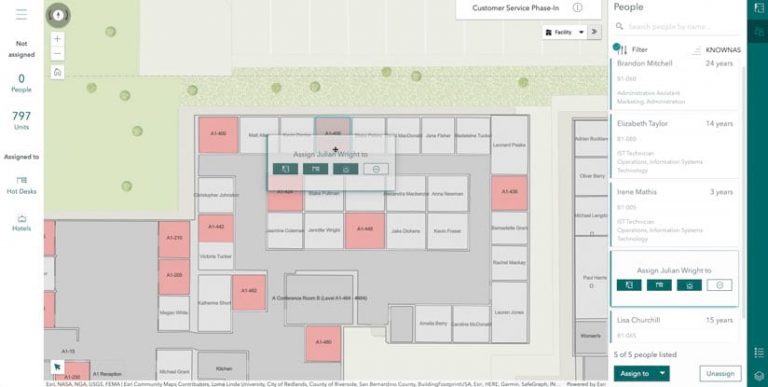
With Indoors, it’s possible to use GIS to do this responsibly and accurately. The software allows users to aggregate, visualize, and analyze indoor spatial data on 2D and 3D maps, apps, and dashboards, creating a new level of transparency when it comes to facility operations. For example, operations managers can employ Space Planner, a browser-based app, to better understand employee seating arrangements. They can see where there are social distancing conflicts, such as desks that are grouped too closely together, and reorganize people’s work spaces to ensure compliance with safety regulations. Space Planner also allows analysts to model various social distancing parameters so they can visualize areas of concern and map out safe seating assignments.
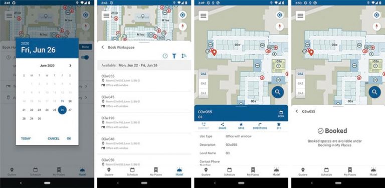
Indoors enables users to publish space plan changes immediately via its native mobile app and web-based viewer. Having up-to-date indoor maps of office buildings and other work spaces makes it easier for employees to interact confidently with their new workplace arrangements. They can use the mobile app and viewer to reserve conference rooms and navigate to meetings, assets, amenities, and other points of interest.
Building occupants can also use Indoors to report facility issues—for example areas that need cleaning. In the mobile app or viewer, all they need to do is mark the space on a map, upload a photo (though that’s optional), and submit a ticket. Once the ticket is submitted, cleaning staff receive a notification telling them exactly what and where the problem is, and then they can use Indoors to navigate directly to the area of concern.
Leveraging Unused Areas for New Uses
Another key way that organizations can employ Indoors is to build resilience into their operations. As the pandemic has revealed, even successful businesses experience severe disruptions if they lack measures to ensure business continuity—especially when physical spaces and organizational operations have to be adjusted at breakneck speed.

With lots of employees working from home now and some organizations considering making flexible work arrangements more the norm, ArcGIS Indoors can help businesses gain insight into current space usage and evaluate what they’ll need in the future. Not only does this reduce costs, but it can also increase employee happiness, help organizations differentiate themselves from the competition, and better prepare businesses for other potential challenges.
For instance, after the pandemic, every employee may not need a personal work space on every workday. Organizations could turn unoccupied spaces into office hotels—individual workstations that employees can book for a certain amount of time. With office hotels, users could build a list of work space criteria in the Indoors app and viewer. Employees could choose from those amenities when booking an office hotel. What’s more, Indoors allows facilities managers to keep track of office hotel reservations so these spaces can be sanitized after use by employees.
Digitizing Facilities Management
The COVID-19 pandemic has revealed that having a sophisticated digital workplace operations system in place makes it easier to enhance facility safety and respond to unexpected events and disasters. By employing ArcGIS Indoors to reenvision indoor spaces and make adjustments to how real estate is managed, organizations across a range of industries—from government agencies and nonprofits to private businesses large and small—can increase employees’ awareness of their surroundings and provide a much clearer common operating picture to those who manage facilities. Isn’t that something we could all use when things seem so uncertain?
Get more information on Indoors or to get in touch with an Esri representative.

