The themes of the 2023 Esri User Conference—creating the world you want to see and bringing science to action—continue to resonate.
It’s been another year of bizarre extremes—of climate collapse, even—as human-caused climate change and a strong El Niño event have combined to create an atmosphere that’s warmer now than it has been in the past 125,000 years.
In July, the global average daily temperature of the earth was higher than humans have ever recorded. Phoenix, Arizona, reached a temperature of at least 110 degrees Fahrenheit (43.3 degrees Celsius) for 31 straight days, shattering its previous record of 18 consecutive days, and with little in the way of nighttime cooling. China reportedly set a new heat record of 126 degrees Fahrenheit (52.2 degrees Celsius). The Persian Gulf International Airport in Iran reached a record-setting heat index (the combination of air temperature and dew point to estimate a “feels like” number) of 152 degrees Fahrenheit (66.7 degrees Celsius). Additionally, a superheated atmosphere has held onto an inordinate amount of moisture, causing record-breaking rains and flooding all over the world.

As my friend and colleague Dr. Katharine Hayhoe, chief scientist of The Nature Conservancy, often says, “Climate change is loading the weather dice against us.” The more carbon we produce, the more the dice are loaded against us, and the worse conditions become—regardless of where we live. Everyone, everywhere is affected.
It continues to be clear that climate change is the most critical challenge of our time. It requires immediate and effective action, including cutting our carbon emissions as much as possible. But there is another effective action we can take: applying GIS, which is uniquely suited to address this singular challenge.
Now, anyone can learn how to take climate action with GIS, guided by rigorous science and sound workflows. And it comes at no cost!
How is this possible? Many of you, dear readers, will likely have guessed that I’m talking about a massive open online course (MOOC).
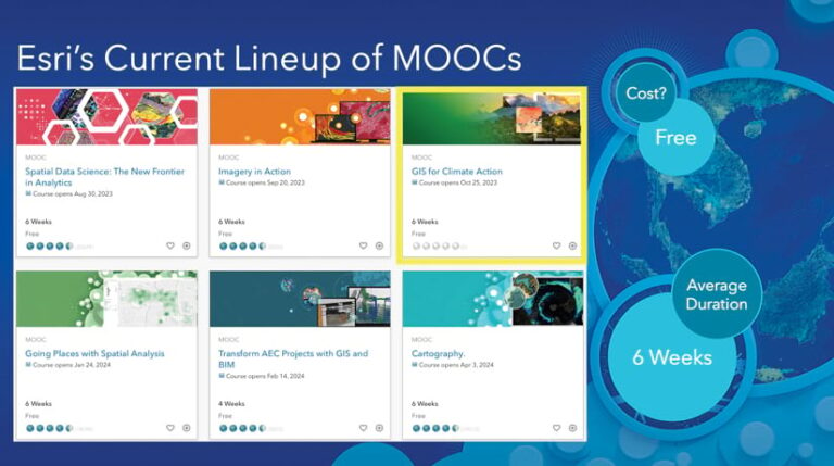
Esri has a rich catalog of very successful MOOCs delivered by Esri Academy, and the newest offering is GIS for Climate Action. The course began on October 25, but there is still time to join and catch up! Registration for this first offering of the course closes on November 8 at 11:59 p.m. (PT). It will run again, however, in May and June 2024.
The Benefits of Taking a MOOC
MOOCs have become one of the fastest and most effective means of transferring knowledge and skills to those who would normally not have access to this information—especially given the costs of higher education. These courses also offer a very effective mode of learning that can easily complement or supplement traditional university learning.
Esri MOOCs are free of charge, come with free access to the software and authoritative data that learners need, and are taught by Esri’s most skilled and communicative staff. Past students rate these courses highly for the ways in which they illustrate how to apply the geographic approach to create data-driven insight and help organizations, communities, and even individuals take effective action. Participants can work at their own pace, at any time of day or night, and Esri MOOCs typically require only about two to three hours of study per week. What’s more, attendees can learn a lot from their peers all over the world via discussion threads and social networking, which can be quite fun!
Participants who finish all the coursework receive a certificate of completion that some colleges and universities may accept for continuing education credit or that may enable students to enhance their grade in an existing college course. MOOCs are also highly prized as professional development training for staff members in corporate or other organizational settings. This said, it is not mandatory to complete the MOOC; everyone can participate as much or as little as they are able to.
A Great Opportunity to Learn a Mix of Skills
Esri MOOCs introduce GIS concepts and skills such as visualizing data; using analytical tools to discern patterns and relationships; and sharing the results via maps, apps, and dashboards—all while learning about the latest advancements in ArcGIS technology. Thus, participants can use MOOCs as an important stepping stone on their journey toward gaining more extensive training.

GIS for Climate Action takes all this one step further by focusing exercises and discussions around the scientific principles of climate change. These include how to define greenhouse gases and their causes and effects, how to best understand and advocate for net-zero emissions, how to distinguish the concept of mitigating climate change from the notions of adapting to and being resilient against it, and how to visualize climate change using various climate models.
The course also offers ample opportunities to simply talk about climate change. If you are worried about climate change and want to make a difference, taking climate action begins with the simple act of talking about it. Communicate how it affects the people and places you love and the issues you care most about, such as the implications of climate change on energy grids, food supplies, transportation, racial equity, and social justice. According to environmental journalist Sara Peach, “‘Talk’ is the fertile field in which cultural change begins; in its absence, it’s impossible for a group of people to solve a problem.”
Gaining Exposure to Key Concepts, Approaches, and Organizations
Crucial questions that will be asked and discussed in the GIS for Climate Action MOOC include the following:
- How can you solve climate change-induced problems using GIS?
- How can web apps help you recognize climate change indicators?
- How does GIS actually track a carbon footprint—even the digital carbon footprint left every time you access a particular website?
- What are the ways that GIS tools best support greenhouse gas mitigation efforts, and how do you implement these tools yourself?
- How can you use ArcGIS Instant Apps or ArcGIS Dashboards to create apps and dashboards that help identify the impact of climate hazards over time, including within the areas that you live and work?
- How do you assess vulnerability and risk using GIS, and how do you take that even further by creating and implementing a climate change adaptation plan?
- What does it really mean to take action in your own community through various service and education efforts?
GIS for Climate Action also incorporates many of the approaches employed in the United States federal government’s US Climate Resilience Toolkit and its real-time Climate Mapping for Resilience and Adaptation (CMRA) geospatial portal. In addition to the main lessons, participants will be exposed to amazing supplemental resources from other organizations that Esri partners with, such as Project Drawdown, The Nature Conservancy, the University of Redlands, and various state and local government agencies.
The new course has been a labor of love by an amazing team of colleagues at Esri, including coleader of Esri’s climate community of practice Steve Kopp, Esri Disaster Response Program operations manager Jeff Baranyi, Esri commercial technology consulting team lead Jessica Bello, and Esri chief medical officer Este Geraghty.
Please join us on the path toward generating positive climate action and find out how to use the geographic approach to create the world you want to see. Register now at GIS for Climate Action. You have until November 8 at 11:59 p.m. (PST) to do so.
I’ll see you in class!


