People, properties, and businesses around the world are affected by city planning and zoning. But planning documents and zoning ordinances can be several hundred pages long. They often contain countless maps, graphics, charts, illustrations, technical diagrams, and reference images. This makes them difficult to use and understand.
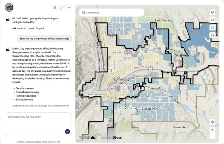
To help property and business owners navigate planning and zoning information, Esri partner Houseal Lavigne created EuclidHL, an AI-powered planning and zoning assistant that is always available, focuses on accuracy, is community specific, and interfaces with ArcGIS technology. Leveraging GIS, generative AI, and large language models (LLMs), EuclidHL simplifies access to and understanding of a community’s planning and zoning information by answering users’ questions in clear and concise language with supporting graphics and maps.

City Plans and Zoning Ordinances Hold Answers
All cities, from small towns to large metropolitan areas, want to be vibrant and allow residents and businesses to thrive. To achieve this, cities develop comprehensive plans that establish a vision, along with the goals and strategies needed to see that vision become reality. Throughout the United States and in some other countries, these plans are legally recognized as the city’s official policy document for growth, land use, and development.
Going hand in hand with planning is zoning, one of the most powerful implementation tools available to cities. Zoning regulates the use and development of all land, ideally in a manner that is consistent with the city’s plan.
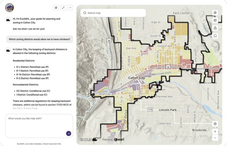
Every day, city staff get peppered with questions. “What is the city’s approach to affordable housing?” “Where can I open a restaurant?” “Can I have chickens in my backyard?” “What growth areas are targeted for annexation?” “What are the city’s sustainability initiatives?” “What is the process for getting a mixed-use development approved?”
The answers to these questions can be found in the city’s plans and zoning ordinances. This information is important to everyone, from city staff to the public, yet it is difficult to find. It needs to be accessible, accurate, and easily understood.
The Challenges of Finding City Information
While municipalities post their zoning codes and planning documents online, the sheer size and complexity of these resources is difficult to mine for answers. Voluminous text, charts, and tables—along with countless maps, diagrams, and illustrations—comprise a city’s policies and regulations. Even for trained city staff and officials, finding the right answer to a question is often challenging.

What’s more, municipal planning staff are not available 24 hours a day, seven days a week. Even during normal business hours, they have other responsibilities, tasks, and projects that demand their attention. But what if someone gets inspired over the weekend to open a business? What if a developer or contractor needs information after hours? What if a city council member is looking into a constituent’s concerns after the evening’s city council meeting? These issues crop up all the time, not just on weekdays between the hours of 9:00 a.m. and 5:00 p.m.
So the team at Houseal Lavigne took on a challenge: how to make a city’s planning and zoning information available all the time in a way that is user-friendly, easy to understand, accurate, and community specific—and that fully leverages a city’s commitment to GIS. Essentially, the team wanted to develop a city planning and zoning expert that is always available.
GIS as a Central Component of the Solution
EuclidHL is a GIS-enabled, AI-based planning and zoning assistant that answers community-specific questions in easy-to-understand language, graphics, and maps. To create this tool, the team at Houseal Lavigne leveraged its extensive GIS, visualization, and technology expertise, along with the company’s experience working with hundreds of cities across the United Sates on planning and zoning projects. GIS data delivers a clear picture of where the effects of planning and zoning take place, so the team made it a central component of the assistant.
Members of the team realized that they could put a city’s planning policies, vision, and priorities together with zoning and development regulations and use that to build the instruction set for an LLM. This would limit the LLM’s responses to the adopted regulations and policies detailed in specific planning and zoning documents.

Since planning and zoning text is geospatial in nature, the team also realized that an LLM could use the text from planning and zoning documents to query and access GIS data. The team decided to call this combination of generative AI, planning documents, zoning ordinances, and GIS “EuclidHL”—a nod to the 1926 Supreme Court case, Village of Euclid v. Ambler Reality Co., that legitimized the use of zoning as a tool to regulate land use and development.
An Agent-Based LLM Delivers Specific Answers
EuclidHL works by using an agentic framework, an AI system that makes decisions and takes actions on its own. EuclidHL’s agent can adapt its responses to different questions without human oversight. It may request clarification, however, during a dialogue.
The agent knows to limit the sources of its information to a specific set of planning and zoning documents, GIS data, maps, 3D scenes, and an engagement platform such as ArcGIS Hub. EuclidHL can also interact with ArcGIS Urban planning projects, enabling it to respond with information about urban development scenarios and zoning capacities. The agent allows the LLM to fetch, reformat, and display information while greatly reducing the likelihood that it will invent, or hallucinate, information when it is uncertain of its response.
The agent also employs a series of defensive tools to prevent unsuitable questions or responses. EuclidHL users cannot use the tool to inquire about subjects that are not related to getting a city’s planning or zoning information. Unsuitable questions are politely declined. Moreover, all conversations are logged and can be reviewed by an administrator and flagged for further analysis by Houseal Lavigne staff.
How EuclidHL Works
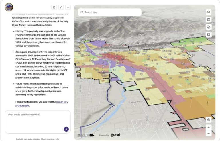
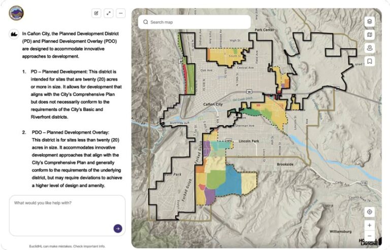
When a resident, developer, city leader, or anyone else submits a question to EuclidHL, the question is forwarded to the EuclidHL agent, which determines how to respond. A response can include text and graphics from zoning and planning documents; references to ArcGIS web maps, scenes, and feature layers; and links to supporting documentation such as building permits and variances. Included in the response is a set of instructions. These instructions are passed to ArcGIS API for JavaScript, which renders the maps, scenes, feature layers, and graphics, and displays text within the chat box.

EuclidHL is currently in use in Cañon City, Colorado, and select other cities in the United States. It provides users with reliable, defensible, and locally specific answers to questions about home additions, fences, acceptable use of property, locations for businesses, municipal plans for growth, plans for new housing, open spaces, annexation, transportation, mobility improvements, and more.
Users can ask EuclidHL common questions, such as “Can I raise chickens in my backyard?” or “What are the restrictions on building accessory dwelling units (ADUs)?” Whenever EuclidHL answers a question, it responds with a text-based answer and displays supporting GIS data on a map or in a 3D scene.
In addition to presenting web maps and scenes that automatically change, pan, and zoom depending on the conversation, EuclidHL will return graphics from legal codes, ordinances, and plans when asked specific planning and zoning inquiries. The graphics include diagrams that help explain required yard setbacks, minimum distances to structures, design guidelines, landscape standards, sign types and requirements, and other property and development regulations.
Community Support in the Age of Generative AI
For a city’s residents, business owners, and civic leaders, generative AI—especially AI assistants—offers an easier way for them to get answers to planning and zoning questions. But the responses must contain more than just text, especially since every planning and zoning inquiry is anchored in geography. EuclidHL fuses text responses with maps, 3D scenes, planning and zoning support documentation, and graphics, providing answers to community members when they need them.

