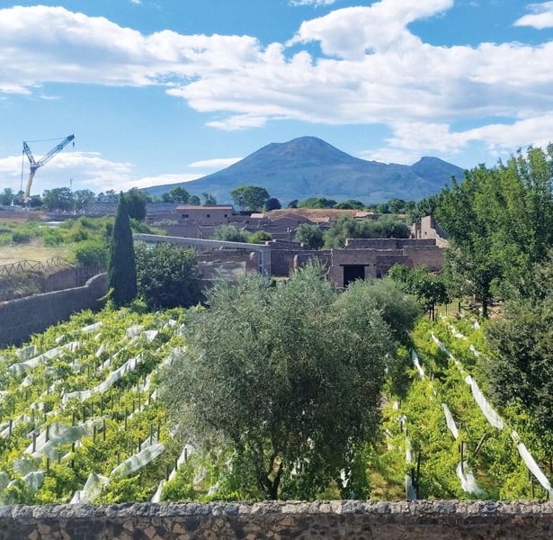
For archaeologists, the ancient city of Pompeii in southern Italy—located less than six miles south of Vesuvius, the infamous volcano that destroyed the city in 79 CE—has garnered much interest over the centuries. Yet some areas of the United Nations Educational, Scientific and Cultural Organization (UNESCO) World Heritage site remain understudied and even largely unexplored.
Currently, a team of researchers, led by Dr. Allison Emmerson of Tulane University, is exploring Insula 14, a block in the southeastern part of the city that could reveal new information about Pompeii’s early existence, how the city developed over time, its economy and infrastructure, and the lives of residents who lived on the margins. The project, called Pompeii I.14, includes a digital data initiatives team that is employing geospatial technology to more efficiently and accurately collect, organize, analyze, visualize, and share the data that’s being unearthed at the site. ArcGIS Survey123, ArcGIS Pro, ArcGIS Dashboards, and web scenes in ArcGIS Online are working in concert to improve daily decision-making on the ground and disseminate project findings in compelling formats more quickly than ever.
Tools That Transcend Traditional Methods
Most archaeologists are familiar with the benefits of using geospatial technology for their work. Archaeological research generates mountains of spatial, metric, and observational data that gets unwieldy as archaeologists try to make sense of it all. Employing GIS to assist with data collection, management, and analysis can improve archaeological practice and reveal patterns that facilitate deeper understanding of how people lived in past societies as well as the complexities of human culture.
The focus of the digital data initiatives team, which joined I.14 in October 2021, was to implement a paperless data collection workflow that would easily tie descriptive data, photographs, and sketches recorded on-site to the detailed and highly accurate 3D models the team was planning to produce of the study area. In looking at different software solutions, it became clear that Esri technology provided a one-stop shop for all the apps that would be needed for the project.
ArcGIS Survey123 forms could be used to record data on-site and implement paperless workflows. That data could be linked to dashboards made with ArcGIS Dashboards to keep track of progress and foster collaboration during the excavation. ArcGIS Pro excels at managing, analyzing, and visualizing both 2D and 3D data. And all three solutions easily link to ArcGIS Online, where the digital data initiatives team built a web scene that allows project participants to revisit the excavation site virtually (to review earlier phases of the excavation, for example) using digital tools that transcend traditional archaeological methods.
A Paperless Process Fosters Agility
In the lead-up to I.14’s summer 2022 excavation at Pompeii, members of the digital data initiatives team used Survey123 to design digital data entry forms for various aspects of the project. The custom forms would work on Apple iPad Pro tablets, and researchers would use them to record data about stratigraphic units (SUs), discrete layers or features in soil that develop through natural processes or human activity; each of the artifacts found in them, including ancient plants and ceramics; and the architectural features of Insula 14.
The SU form was the principal form used during the excavation because the number assigned to each SU became the unique ID to which other data was linked. Each time an SU was excavated, researchers completed a corresponding form that included all the data collected for that SU, such as soil properties, physical descriptions, and in-field interpretations; metric data, which ranged from elevation measurements to the counts of ceramic fragments found; and excavation photos and field drawings. Other forms—such as the Finds form for artifacts and Pottery form for ceramics—also created records that were linked to each SU using the SU number. This enabled the team to query not only the data collected in each SU but also the data pertaining to recovered artifacts.
During the excavation, trench supervisors were given iPad Pro tablets and Apple Pencil stylus pens to record data in their archaeological areas. The Survey123 app was loaded onto the iPads, and the project forms were accessible through the app. Once trench supervisors began to dig an SU, they opened a new SU form in Survey123 and started recording their data. They took photos of their SUs using the iPad’s camera and created scaled digital field sketches in another app called Concepts. These were saved as attachments in the Survey123 form. When an SU was finished, the trench supervisors saved their forms locally on the iPads and then, when they had access to Wi-Fi or a cell network, sent them to cloud storage via ArcGIS Online. Because Survey123 collects location data, it was easy to spatially link 3D data to researchers’ field notes, images, and sketches.
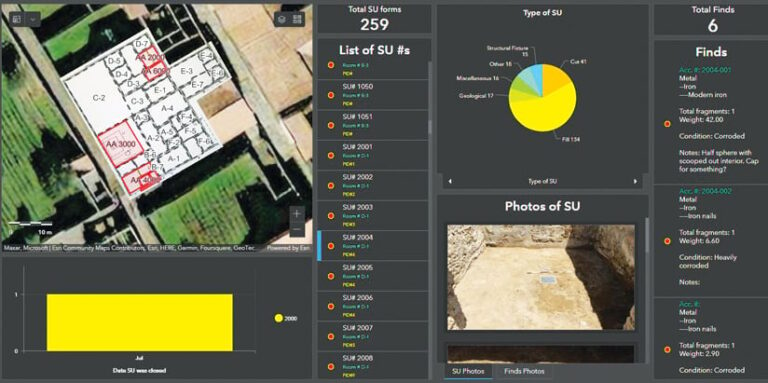
The digital data initiatives team also employed Dashboards to create an interactive dashboard that researchers at Pompeii used to track the dig’s progress. Taking the data being submitted by the Survey123 forms, the dashboard showed a map of the excavation, broke down the various types of SUs, tallied and described all found artifacts, and displayed photos of the SUs and archaeological finds. The dashboard allowed researchers to check their data while still in the field, which improved data quality, and aided in making the day-to-day decisions required to keep an excavation moving forward smoothly.
Seeing the Excavation in a Whole New Way
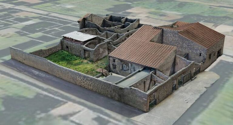
Another responsibility of the digital data initiatives team was to document the I.14 excavation in 3D. The team relied on structure-from-motion (SfM) photogrammetry to do this, which entails generating 3D models from 2D imagery, such as a series of digital photographs. This technique can be used to document 3D space with high accuracy and is gaining popularity in archaeological workflows.
Before the excavation, team members created a scaled and georeferenced 3D model of Insula 14 that would serve as the base to which all subsequent 3D models would be aligned. The team carefully and evenly placed alignment points—small dots of highly visible pink paint—throughout the interior spaces where the excavation would take place. Calibrated scale bars with coded targets were also situated throughout the site to serve as internal checkpoints.
Once all the alignment points were in place, the team took photos of the insula using both terrestrial and aerial photography. Ground control points (GCPs) were recorded using a total station and high-accuracy real-time kinematic (RTK) GPS receivers that were accurate to within about 2 centimeters. The GCPs were used to georeference the final base model.
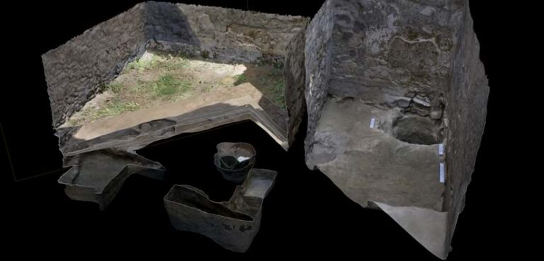
As the excavation got underway, supervisors of the three teams that were working simultaneously in seven archaeological areas of Insula 14 were told to identify moments that required 3D documentation. A member of the digital data initiatives team would then photograph the excavation at that stage, ensuring that all available alignment points were captured in the images to facilitate alignment with the base model. Moments later, the team would process the images in the field lab using a standard SfM workflow in Agisoft Metashape Professional to create a digital twin of the excavation at that moment in time. In the end, each excavation that took place in Insula 14 had a series of corresponding models that showed the progression of the excavation through time. And the models contained the geospatial, morphological, and visual information for each SU.
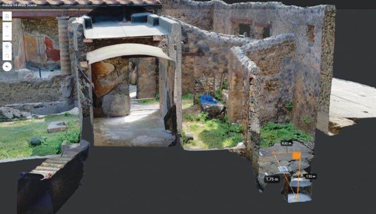
When the photo-realistic 3D models of each excavated area were ready, the digital data initiatives team imported them into ArcGIS Pro in a local scene. The data that researchers recorded using Survey123 was then spatially linked to each SU, as documented in the 3D model. This was accomplished by using the Move To tool in ArcGIS Pro to relocate the points associated with each record to the x-, y-, and z-coordinates of each SU location. Finally, all this was transferred to an interactive web scene in ArcGIS Online.
In the web scene (which the researchers plan to make publicly available once they publish their findings), viewers can virtually explore the excavation site by using tools that measure and slice the 3D models. This allows them to see all the data and notes that were collected in the field and explore stratigraphic relationships in a whole new way.
The Benefits of Efficiency and Accuracy
While traditional methods of archaeological documentation are still useful, I.14 researchers experienced myriad benefits from relying on geospatial technology in Pompeii.
With Survey123 allowing archaeologists to instantly digitize their field notes and other records, the team saved the hours it usually takes to digitize data. This paperless workflow also allowed everyone working on the project to share their documentations widely—to a team spread across states and countries—and has cut down on the data loss that typically stems from digitization errors, bad handwriting, and accidentally discarded or damaged notes. Being able to use a dashboard to monitor the excavation in near real time also improved decision-making on the ground and kept things running efficiently.
Having all the documentation, including photos and drawings, available quickly in scaled 3D models and in an ArcGIS Online web scene has enabled researchers to disseminate their project findings with everyone from students and GIS lay users to project stakeholders and the public. These easily accessible records have also begun to facilitate useful discussions about methods of digital and 3D cultural documentation in archaeology.
The I.14 project has made it clear that employing GIS-based methods for field documentation in archaeology is viable and advantageous. The team is looking forward to refining its processes and techniques in future excavations at the site.


