Smart Communities Need to Be Technologically Fit for the Future
Increasingly, cities and citizens are having to confront global trends such as growing urbanization, escalating poverty, reductions in public services, and financial pressures from governments and administrations. But over the last decade, technology development has been exponential, creating a brave new world of opportunities to harness geospatial intelligence for societal good. High-quality geographic data can now enable effective decision- and policy-making in government. It can support sustainable development and deliver real benefits to a community, region, or nation.
Having accurate location and attribution information, combined with a working knowledge of assets and resources, helps authorities design and focus public services and engage citizens early in these processes. And as cities get smarter through the proliferation of sensors and the Internet of Things (IoT), the way these services work can be adjusted in near real time. Thus, governments and businesses around the world are recognizing that they need to be geospatially fit for the future.
That is why Ordnance Survey, Great Britain’s national mapping agency, created the geospatial maturity assessment. Organizations and administrations can use the tool to gauge how advanced they are at data collection, corporate governance, stakeholder engagement, operations management, and more. Since geospatial information affects everything—from policies and the economy to an individual’s life chances—knowing the geospatial data a community has available and how to use it most efficiently is key.

Organizations and administrations that have a rich understanding of information about location and place are more likely to respond skillfully to evolving global challenges. With the right infrastructure, the right data management methods, the right technology, and the right capabilities, cities can realize their geospatial potential.
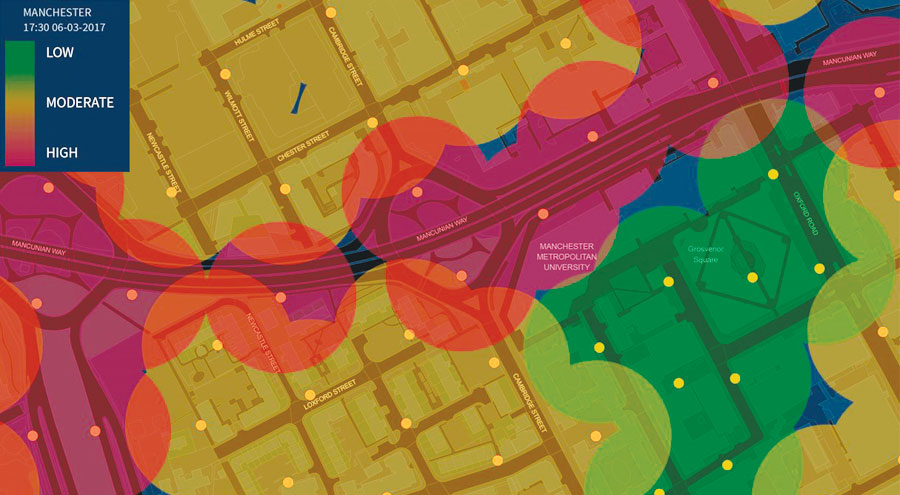
Manchester, in the United Kingdom, is leading an IoT/smart city demonstrator project called CityVerve, in which geospatial data is being used to support and empower citizens and decision-makers. Ordnance Survey has captured location and attribution data about thousands of street-based assets—such as lampposts, road signs, and manholes—and is using ArcGIS Online and other editing tools to manage and visualize the data. The mapping agency is also sharing the information with project partners, who are working with community groups to understand the problems they need to solve and how CityVerve can help them create solutions. All this is helping Manchester reach its geospatial potential.
Making certain lamppost information public, for example, not only aids Manchester’s city council in managing and maintaining a resilient lighting system, but it can also help city officials plan the deployment of air quality and noise sensors or assist startups in developing urban navigation solutions. Having data on parking and road markings can support the city council in capacity planning and ensuring compliance with regulations. It can also assist technology companies or transportation authorities with building real-time services for drivers.
What’s more, making this geospatial data available through an open standards approach promotes interoperability and innovation. Ordnance Survey actively champions the development of open standards to maximize the value of organizations’ location data, allowing their information to reach more users and create more opportunities.
Accurate and open data from Ordnance Survey already underpins IoT, 5G, and driverless vehicle test projects, as well as other smart ventures, in Manchester and across the United Kingdom. Having mature geospatial data and services is the only way to support undertakings like these, which ultimately help cities make smarter location-based decisions, save money, and improve the lives of their citizens.
When organizations, cities, and regions understand how mature their geospatial data and processes are, they can begin to meet their objectives—opening up more data, ensuring better transparency, and reducing costs. Ordnance Survey International can help organizations and administrations refresh their geospatial strategies, improve the management and flow of information, and optimize their operational processes.
Take the geospatial maturity assessment now and see how making improvements to geospatial data and services can help transform your city.
Ordnance Survey maintains Great Britain’s fundamental geospatial reference base, OS MasterMap. Ordnance Survey International, which helps customers all over the world develop their geospatial capacity, is a wholly owned subsidiary of Ordnance Survey.
About the Author
Simon Navin is the program manager for smart projects at Ordnance Survey. He currently manages, coordinates, and delivers the organization’s smart/IoT sector ventures, including CityVerve, the United Kingdom’s key IoT demonstrator project. Navin is a chartered surveyor (MRICS) and a member of the Chartered Institution of Civil Engineering Surveyors (MCInstCES), Anglia and Central Region committee. Follow him on Twitter.

