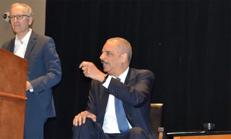
On behalf of the American Association of Geographers (AAG), I’d like to publicly thank former US attorney general Eric Holder for joining 9,000 geographers and GIS specialists in April at the AAG Annual Meeting in Washington, DC. He chairs the National Democratic Redistricting Committee (NDRC), which seeks to combat unfairly gerrymandered districts leading up to 2021, when districts will be redrawn after the decennial US census.
AAG meetings are attended by geographers and GIS professionals from a wide range of backgrounds. Our field unites some of the best minds to tackle today’s toughest issues—including gerrymandering and redistricting—always through a spatial lens. In regard to the United States’ social challenges, such as divided politics and fair representation, thinking spatially can have a huge impact. For better and for worse, geography and GIS have revolutionized how congressional districts are now created and manipulated—and how they impact our national and state elections.

Holder’s career in public service began long before his appointment as the eighty-second attorney general of the United States. After graduating with a law degree from Columbia University, he started out as a trial attorney in the Public Integrity Section of the US Department of Justice’s Criminal Division. Under the administration of former president Bill Clinton, he served as deputy attorney general, and under former president Barack Obama, he became the attorney general. He was the third-longest-serving attorney general in US history and the first-ever African American to hold that position.
His lifetime of public service has been unfalteringly dedicated to the pursuit of civil rights and equal justice. Under his leadership, the Department of Justice pursued the defense of voting rights, federal criminal justice reform, environmental protection, and national marriage equality, just to name a few highlights. He has fought tirelessly for equality under the law and fair representation for all Americans, and his current project does not stray from these themes.
Since the end of his tenure as attorney general, Holder has turned his focus toward an issue of high national importance: gerrymandering. Together with support from Obama and a number of other national leaders, the NDRC is a coordinated effort to make maps fair and ensure that votes count.
GIS is now an indispensable and ubiquitous tool in this process of redistricting. When combined with transparency, public involvement, and statistical measures of fairness, it offers much-needed solutions to addressing the distorted and biased voting districts that now characterize many US elections. Gerrymandering occurs when the geographic boundaries of electoral districts are manipulated, often producing oddly shaped geographic areas, to provide an advantage to one political party over another.
GIS Can Make Redistricting More Efficient and Transparent
Every decade, the lines that determine congressional, state legislature, and local government districts in the United States are redrawn based on new decennial census data. Although historically the process has been opaque, often politically charged, and largely ignored by the public, it is a vitally important exercise because it tremendously affects who can—and will—be elected to represent citizens on the local, state, and federal levels.
Each year, the geographic distribution of the population changes. People are born, retire, die, or relocate. When that happens, it often necessitates redrawing districts to accommodate these changes. The redistricting process is made more challenging because governments must balance competing considerations when redrawing boundary lines.

Congressional and state legislature districts must have equal population to comply with the US Supreme Court’s “one man, one vote” rulings. To abide by the Voting Rights Act of 1965, districts should reflect racial and ethnic diversity. States and local governments can add other constraints as well, such as contiguity and compactness relating to district shape, respect for political boundaries, geographic features, communities of interest, and political fairness.
Because the redistricting process involves who lives where, it is an intrinsically geographic undertaking that requires the integration of many factors, which can be addressed efficiently using GIS. For example, the online Esri Redistricting app is a software-as-a-service (SaaS) subscription that gives state and local governments, the public, and advocacy groups access to the redistricting process while providing government transparency. Interactive Web GIS is a promising technology for drafting redistricting maps because the effects that boundary changes will have on associated populations can be tested interactively and worked on collaboratively.
Redrawing legislative district and precinct lines to determine fair electoral representation is a crucial and complex task. Geographers and GIS specialists can and must engage in this process by bringing their knowledge and essential redistricting information into a transparent and publicly collaborative spatial context.
I concur with what Holder told the thousands of geographers and GIScientists at AAG’s Annual Meeting: “I truly believe this: The work that you do can play a really critical role in the future of our democracy,” he said. “Our democracy has been manipulated through racial and partisan gerrymandering. […] I think that we have an all-hands-on-deck moment for the United States of America.”
Watch Holder’s full talk at the 2019 AAG Annual Meeting.
Contact Doug Richardson at drichardson@aag.org.


